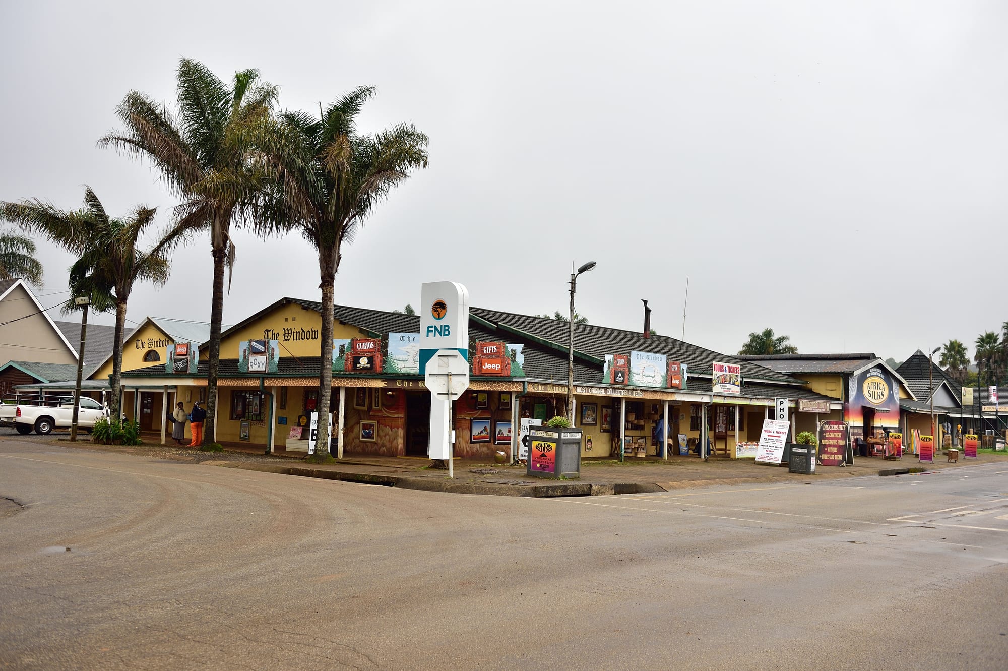
A low row of shops with verandas, painted signboards and palm trees along an empty street corner under a grey sky

Johannesburg, Pretoria & Kruger, South Africa

Graskop

Shops and curio stores along the main street in Graskop, Mpumalanga. (South African Tourism from South Africa / Wikimedia Commons · CC BY 2.0)

A small town on the edge of the Drakensberg escarpment in Mpumalanga, high up where the highveld breaks away towards the lowveld. It grew out of the eastern Transvaal gold era and later lived on timber; today it survives on traffic along the Panorama Route, with the viewpoints of God's Window, the waterfalls and the Blyde River Canyon within easy reach.

Neighbourhoods

  • The main street
    • First-time visitors
    • Best for food
    • Shops and crafts

    Graskop is barely more than a grid of streets around one commercial strip of shopfronts, curio stores, pancake places and small guesthouses. Almost everything a visitor needs sits within a few minutes' walk, and the road through it carries the Panorama Route traffic.

    Open in Maps
  • The escarpment edge
    • Views
    • Walks
    • Quiet

    On the eastern side of town the ground simply falls away into a forested gorge, with the lowveld hazy far below. Viewing decks and short paths along this edge look down into it, a few minutes' walk from the centre.

    Open in Maps
  • The plantation belt
    • Quiet and residential
    • Scenic driving

    Beyond the last houses, pine and eucalyptus plantations cover the hills in dark blocks, cut by forestry roads and streams. The waterfalls and the roads towards Sabie and Pilgrim's Rest run through this country.

    Open in Maps

Things to do

Viewpoints and waterfalls

  • God's Windowviewpoint

    A set of viewing points where the escarpment drops some 700 metres to the lowveld, with a short path up into a patch of mist-fed forest.

    Open in Maps
  • Lisbon Fallsattraction

    The highest waterfall in Mpumalanga, a drop of about 94 metres into a wooded bowl a short drive north of the town.

    Open in Maps
  • Berlin Fallsattraction

    A single narrow fall of roughly 80 metres, viewed from a platform above the pool, named like its neighbour by European prospectors.

    Open in Maps
  • Mac-Mac Fallsattraction

    A 65-metre waterfall on the Mac-Mac River in a forest reserve south of the town, its name a reminder of the diggers who worked the old goldfields.

    Open in Maps

Short trips from the town

  • Bourke's Luck Potholesattraction

    Cylindrical holes scoured into the rock where the Treur River meets the Blyde, crossed by footbridges about 35 kilometres north.

    Open in Maps
  • Blyde River Canyonpark

    A deep canyon of red rock and green slopes, with the three rounded peaks known as the Three Rondavels seen from viewpoints on its western rim.

    Open in Maps
  • Pilgrim's Restattraction

    A preserved gold-rush village about 15 kilometres west, where diggers struck alluvial gold in 1873 and whose corrugated-iron street is now a museum town.

    Open in Maps
  • Sabieattraction

    A forestry town about 30 kilometres south in a valley of plantations and waterfalls.

    Open in Maps
  • Hazyviewattraction

    A lowveld town of banana and macadamia farms below the escarpment, used as a base for the southern part of Kruger.

    Open in Maps
  • Kruger National Parkpark

    South Africa's first national park, whose western gates below the escarpment put a day's game viewing within reach of the town.

    Open in Maps

Eat and drink

Long-standing places and food districts in Graskop. Hours, ratings and directions come from your maps app, always current.

Graskop classics

  • The pancake housesrestaurant

    Graskop is known along the Panorama Route for thick savoury and sweet pancakes, filled with mince, chicken, cheese or cinnamon sugar, and several places on and near the main street make them.

    Open in Maps
  • The main street restaurantsneighborhood

    A short strip of steakhouses, coffee shops and takeaways serving the standard South African road-trip menu of grills, burgers, boerewors rolls and breakfasts.

    Open in Maps
  • Trout from the escarpment streamsrestaurant

    The cold streams and dams around Graskop and Sabie are stocked with trout, which appears smoked or pan-fried on menus across the highlands.

    Open in Maps

Markets and roadside stalls

  • Curio and craft stallsmarket

    Stalls and shops around the main street sell beadwork, carvings, basketry and fabric, much of it made in the surrounding villages and in neighbouring countries.

    Open in Maps
  • Lowveld fruit stallsmarket

    On the roads down towards Hazyview, farm stalls sell bananas, mangoes, avocados, litchis and macadamia nuts from the lowveld orchards.

    Open in Maps

Experience Graskop

History

Graskop takes its Afrikaans name, roughly "grassy hilltop", from the farm on which it stands, high on the Drakensberg escarpment. The area drew outsiders in the 1870s, when diggers working the streams below the escarpment found alluvial gold at Pilgrim's Rest, a few kilometres west, and the rush that followed filled the valleys with tents, trading stores and transport wagons. Graskop was established in the 1880s as a gold-mining camp on the high ground above those workings, and grew into the service point for the district.

When the easy gold ran out the district turned to trees. From the early twentieth century the state and private companies planted pine and eucalyptus across the high rainfall belt between Graskop and Sabie, creating one of the largest planted forests in the country, and sawmills and forestry jobs replaced prospecting. The railway that once served the timber trade has gone quiet, but the plantations still cover the hills.

The third phase began with the road. As motor touring grew after the Second World War, the string of viewpoints along the escarpment — the falls, God's Window, the canyon rim — became the Panorama Route, and Graskop, sitting at its centre with fuel, food and beds, turned into a stop on almost every itinerary between Johannesburg and the Kruger National Park. After 1994 the town was absorbed into the Thaba Chweu municipality with Sabie and Lydenburg. Tourism has since become the mainstay, and the gorge below the cliff edge has been developed for visitors.

Culture & Customs

Graskop is a small highland town with a mixed population, and the languages of the streets reflect the meeting of provinces: siSwati and isiZulu from the Mpumalanga lowveld, Sepedi and Xitsonga from the north, Afrikaans from the farming and forestry families, and English as the common tongue with visitors. Most of the town's working life turns on hospitality, so people are used to travellers and the day has a passing-trade rhythm of arrivals and departures.

Craft selling is part of the local economy and part of the culture. Stalls around the main street offer beadwork, wire and tin work, carved animals, basketry and printed cloth, some made locally and much of it brought in from elsewhere in southern Africa, and quiet bargaining is expected. The town has also become associated with a single dish: pancakes, filled savoury or sweet and eaten at the tables that line the main street, are a running joke and a real tradition among South Africans driving this route.

Outdoor pursuits shape the rest. The gorge below the town draws visitors to its edge and its paths, and hikers, trail runners, anglers and cyclists use the plantation tracks and the escarpment paths. Church life is strong across the community, weekends fill with visitors from Gauteng in the school holidays, and the local calendar follows the forestry cycle and the tourist season rather than any large festival.

Daily Life

Graskop is home to a few thousand people in the town itself, with more in the surrounding settlements and forestry villages, and it forms part of the Thaba Chweu municipality along with Sabie and Lydenburg. The built-up area is small enough to walk across, with a commercial main street, a school, a clinic, a few churches and a residential grid behind, and newer housing spreading outwards towards the edge of the plantations.

Three things pay the bills: forestry and the sawmills of the district, tourism along the Panorama Route, and the government and municipal jobs that come with being a service town. Many households depend on seasonal or informal work — guiding, craft selling, hospitality — which makes the quiet winter weeks and any downturn in travel felt quickly. Wages are low, unemployment high, and commuting to Mbombela or the lowveld farms is common.

The day starts early, with minibus taxis running to Sabie, Hazyview and the plantations, and ends early too: shops close in the late afternoon and the town is quiet by dark except for guesthouse verandas. National problems arrive here as elsewhere — power interruptions, water supply that fails when pumps or pipes break, potholes on the district roads — and are met with generators, tanks and patience. Mist is the other constant, arriving from below and closing in the streets in minutes.

Food

The dish people associate with Graskop is the pancake, a soft, thick crêpe folded around fillings rather than the thin French kind. Savoury versions come with curried mince, chicken and mushroom, beef and cheese, or spinach and feta; sweet ones with cinnamon sugar and lemon, caramel or berries. Several establishments on and around the main street make them, and stopping for one is close to a ritual on the drive between Johannesburg and Kruger.

The rest of the local table is standard South African highland fare. The braai — boerewors, a coiled spiced sausage, lamb chops and steak grilled over coals — is the weekend centre of family life, eaten with pap, the stiff maize porridge, and chakalaka, a spiced vegetable relish. Biltong and droëwors, air-dried spiced meat, are sold in the shops for the road. Cold streams and dams around Graskop and Sabie hold trout, which turns up smoked or pan-fried on menus across the escarpment.

Down the pass the lowveld supplies fruit, and roadside stalls on the Hazyview road sell bananas, mangoes, avocados, litchis and macadamia nuts, along with achar, the oily mango pickle. Sweet things lean Afrikaans — koeksisters, milk tart, malva pudding — and the drinks to try are rooibos tea and Amarula, the cream liqueur made from the marula fruit that grows in the lowveld below.

Planning tools

Budget

Graskop is one of the cheaper stops on a Mpumalanga trip. Guesthouses and backpacker lodges in the town cost far less than lodges nearer the parks, meals are inexpensive, and the viewpoints charge only small entry fees at the gates. The main expense is a hire car, since nothing on the Panorama Route is reachable without one.

Daily Budget Midrange
USD 100–190 (guesthouse room, restaurant meals, hire car and fuel, entry fees)
Daily Budget Shoestring
USD 40–70 (backpacker bed or campsite, self-catering, shared car, viewpoint fees)

Staying in Graskop and driving out to the canyon each day costs much less than the lodges nearer Kruger, and most viewpoints charge a small fee in cash or by card at the gate.

Best Time to Visit

April to September brings the clearest air, when the lowveld view from the escarpment opens up and the days are mild. Summer, from November to March, is green and the waterfalls are full, but afternoon cloud and mist often close the viewpoints, sometimes for days. Winter mornings are cold and the grass is dry and brown.

Suggested Number of Days

A night or two covers the town and the nearest viewpoints. Three or four allow the whole Panorama Route at an unhurried pace, the gold-rush village and a run down the escarpment. Weather is the main variable, as mist can shut the views and force a wait.

First Visit
1–2 days
With Surroundings
3–4 days

Transportation

There is no useful public transport for visitors. Almost everyone arrives by hire car, on a self-drive tour between Johannesburg and Kruger, or on an organised minibus tour of the Panorama Route. Minibus taxis link Graskop with Sabie, Hazyview and Mbombela for local people. The town itself is covered on foot in a few minutes.

Fill up before the long stretches between towns, watch for mist, logging trucks and potholes on the escarpment roads, and drive these mountain routes in daylight.

Airport & Station Connections

Graskop is about 380 kilometres east of Johannesburg, roughly five hours by road on the N4 and then up the escarpment, and about 60 kilometres north of Mbombela. The nearest airport is Kruger Mpumalanga International near Mbombela, about an hour and a half away, with flights from Johannesburg and Cape Town; Hoedspruit and Skukuza are the other lowveld airports.

Walkability

The town is small and flat enough to cross on foot in ten or fifteen minutes, and the escarpment edge with its gorge viewpoints is within walking distance of the centre. Everything else — the falls, the potholes, the canyon — needs a vehicle. Pavements are patchy, and walking the main road after dark is not advisable.

Safety

The Panorama Route is heavily travelled and the escarpment towns see far less crime than the big cities, but thefts from parked cars at viewpoints and quiet laybys do happen, and some viewpoints are staffed only during the day. The greater risks are on the road — mist, sharp bends and heavy timber traffic — and near waterfalls, where wet rock above a drop is dangerous. The escarpment itself is high and cool; the lowveld below it is a malaria area, as the region's health advice sets out.

Don't display phones or jewellery, keep the car locked in traffic, avoid walking the main road after dark, take malaria precautions for the lowveld, and drive with headlights on and caution for animals and pedestrians. Check current official travel advice before travelling.

Climate

Graskop sits high on the edge of the escarpment, which makes it noticeably cooler and wetter than the lowveld a few kilometres east. Summer here runs from December to February. Rain falls mostly in summer, and cloud rolling up the escarpment can wrap the town in mist at any time of year.

Summer
warm and often misty, around 20–27°C by day, with heavy afternoon thunderstorms
Winter
dry and sunny, around 17–20°C by day, with cold nights near freezing

Local Customs

This is a small, mixed highland town where siSwati, isiZulu, Sepedi, Afrikaans and English are all heard, and greetings before business are normal courtesy. Tipping is customary: around ten per cent in restaurants, and a few rand for the car guards in yellow bibs who watch parked cars. Craft sellers expect polite bargaining. Dress is casual, but the escarpment is cold enough for a jacket most evenings.

Ask before photographing people or their stalls, treat the viewpoints' safety barriers seriously, and carry small notes and coins for parking attendants and gate fees.

Common Payment Methods

The currency is the South African rand. Cards are accepted in shops, restaurants and guesthouses in the town and at most of the bigger viewpoints, and there are bank branches and ATMs on the main street. Cash is worth carrying for craft stalls, roadside fruit sellers, small gate fees and tips, since power cuts occasionally knock out card machines.