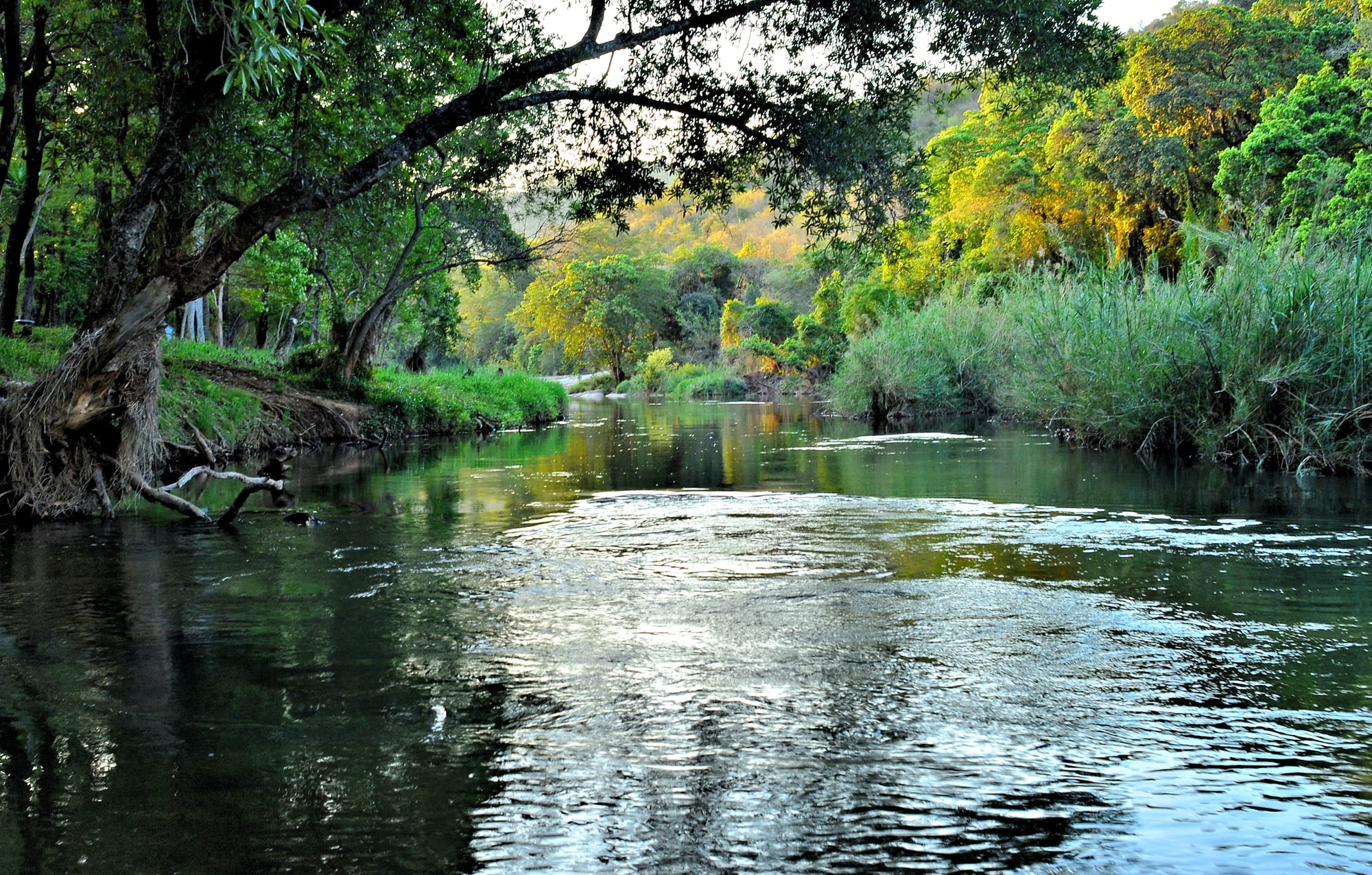
A wide, slow river running between reed beds and overhanging riverside trees in green bush country

Johannesburg, Pretoria & Kruger, South Africa

Hazyview

The Sabie River among riverine trees and reeds near Hazyview in the Mpumalanga Lowveld. (Ossewa / Wikimedia Commons · CC BY-SA 4.0)

A Lowveld town in Mpumalanga where the escarpment drops to the bushveld, spread along the Sabie River among banana and macadamia plantations. Two of Kruger National Park's western gates lie within a short drive, the private reserves of the Sabi Sand adjoin the park nearby, and the waterfalls and canyon viewpoints of the Panorama Route begin on the mountain road above the town.

Neighbourhoods

  • The town centre
    • Supplies and services
    • Close to the main roads

    The crossroads of the R40 and R536 where the shopping centres, filling stations, banks and taxi rank stand. It is the practical stop for food, fuel and cash, busy with traffic between the farms, the gates and the escarpment.

    Open in Maps
  • The Sabie River road
    • Guesthouses and lodges
    • Quiet and residential

    The R536 west towards Sabie, where lodges, cabanas and guesthouses sit above the river among fig and sycamore trees. Hippos and crocodiles live in the pools below, and the road climbs steadily towards the escarpment.

    Open in Maps
  • Towards the Kruger gates
    • Wildlife watching
    • Early starts

    The eastern approach along the R536 and R569 through plantations and bush to the Phabeni and Numbi gates. Accommodation strung along these roads suits visitors who want to be inside the park at opening time.

    Open in Maps
  • The farm belt
    • Local life
    • Farm produce

    The plantations north and south of the town grow bananas, macadamias, citrus and subtropical fruit, with farm stalls, packing sheds and the settlements where much of the working population lives.

    Open in Maps

Things to do

Wildlife

  • Kruger National Parkpark

    South Africa's first national park, whose Phabeni Gate lies about 12 kilometres east of the town and Numbi Gate about 15, opening on to the well-watered southern section where game is most concentrated.

    Open in Maps
  • Sabi Sand Game Reservepark

    A group of private reserves adjoining Kruger north-east of the town, sharing the park's plants and animals, with lodges running guided game drives.

    Open in Maps
  • The Sabie Riverattraction

    The river the town stands on, running east through Kruger to join the Komati in Mozambique, with hippos and crocodiles in its pools and riverine forest along its banks.

    Open in Maps

Around the town

  • Banana and macadamia plantationsattraction

    The fields and orchards around the town grow bananas, macadamias, avocados, mangoes and litchis, sold at stalls along the R40.

    Open in Maps
  • Shangaan cultural villagesattraction

    Cultural villages on the roads out of town stage Shangaan dancing, drumming and demonstrations of homestead life, and sell local crafts.

    Open in Maps

Short trips

  • Graskopattraction

    A small town on the edge of the escarpment, the base for the Panorama Route viewpoints and known for its pancake restaurants and the forested gorge below the town.

    Open in Maps
  • God's Windowviewpoint

    A break in the escarpment wall looking out over the Lowveld far below, often filled with mist and cloud.

    Open in Maps
  • Blyde River Canyonviewpoint

    A deep red-rock canyon on the escarpment, with viewpoints over the Three Rondavels and the Blyde River far below.

    Open in Maps
  • Bourke's Luck Potholesattraction

    Cylindrical rock hollows scoured into the river bed where the Treur meets the Blyde, crossed by footbridges.

    Open in Maps
  • Sabieattraction

    A town in pine and eucalyptus plantations known for the waterfalls around it, among them the Lone Creek and Mac Mac falls.

    Open in Maps
  • Skukuzaattraction

    The largest camp in Kruger, on the Sabie River, with a shop, restaurant, museum and an airport serving the park.

    Open in Maps

Seasonal events

  • Dry-season game viewingMay to September

    Cool, dry months thin the bush and draw animals to the rivers and waterholes, the busiest season for the lodges around the town.

  • Summer fruit harvestDecember to March

    Bananas, mangoes, litchis and avocados come in from the plantations and fill the farm stalls along the roads.

  • Summer storms and green bushNovember to March

    Hot, humid weather and heavy afternoon rain bring newborn animals, migrant birds and full waterfalls on the escarpment, with mist often closing the Panorama Route viewpoints.

Eat and drink

Long-standing places and food districts in Hazyview. Hours, ratings and directions come from your maps app, always current.

Town kitchens and farm stalls

  • The R40 farm stallsmarket

    Roadside stalls sell bananas, avocados, mangoes, litchis and macadamia nuts from the surrounding plantations, along with dried fruit and nut butters.

    Open in Maps
  • The town centre eating placesneighborhood

    Takeaways, bakeries and grill counters around the shopping centres serve pies, fried chicken, burgers and magwinya, the fried dough balls sold everywhere in the Lowveld.

    Open in Maps
  • Lodge and river restaurantsneighborhood

    Restaurants at the lodges along the Sabie River and the escarpment road serve grills, game meat such as kudu or impala, and pap with vegetable relish, often on terraces above the water.

    Open in Maps

Experience Hazyview

History

The Lowveld around the Sabie River was Shangaan and Swazi country, hunted and farmed long before European settlement, and for much of the nineteenth century it was a hard place for outsiders: malaria and the tsetse fly killed both people and cattle, and the transport riders who crossed it towards Mozambique did so in winter when the risk was lower. The name Hazyview is said to come from the haze that hangs over the flats in the hot months.

Two developments made the modern town. The first was conservation: the Sabi Game Reserve was proclaimed in 1898 between the Sabie and Crocodile rivers, and in 1926 it was enlarged and renamed the Kruger National Park, with gates opening on to the western boundary a short distance east of the present town. The second was farming. Once malaria was brought under control in the middle of the twentieth century, the well-watered soils below the escarpment were planted with bananas, citrus and, later, macadamias and avocados, and packing sheds and a service centre grew at the crossroads.

The private reserves west of Kruger — the Sabi Sand foremost among them — later dropped their fences with the park and built a high-value safari industry, while the escarpment road above the town carried a steady flow of visitors along the Panorama Route. Tourism and farming have grown together since, and the town has spread along its roads with shopping centres, craft markets and lodges, its population increased by workers drawn to both industries.

Culture & Customs

This is Shangaan country, and the Tsonga-Shangaan people who live here speak Xitsonga, with siSwati common to the south and isiZulu, Afrikaans and English all heard in the shops. Cultural villages on the roads out of town present Shangaan dancing, drumming, divining and homestead life to visitors, an industry that has also kept alive craft skills — beadwork, basketry, pottery and wood carving — sold at stalls along the R40 and at craft markets.

Life outside the town follows rural patterns: homesteads of several households, cattle and goats as savings and as the substance of ceremony, chiefs and traditional councils alongside the municipality, and church on Sunday for most families, in congregations ranging from Anglican and Lutheran missions to large independent African churches. Weddings, funerals and initiations draw relatives back from Gauteng.

Conservation is part of local identity and local argument alike. Families have worked as rangers, trackers, guides and camp staff for generations, and lodges fund schools, clinics and community levies; at the same time the fences, land claims and restrictions on access are a long-running grievance, and rhino poaching in the nearby park — and the policing that comes with it — is discussed here as local news. Visitors are received warmly and with a directness that assumes they will be back.

Daily Life

Hazyview is a small town whose built-up centre holds only a few thousand people, but it serves a much larger rural population in the settlements and homesteads spread through the surrounding hills, and the wider area counts tens of thousands. The centre has supermarkets, hardware and farm suppliers, banks, filling stations, clinics, schools and a busy taxi rank, and it fills at month end when wages and grants are paid.

Farming and tourism carry the economy between them. Bananas and macadamias are the main crops, with avocados, mangoes, litchis and citrus alongside them, and the picking and packing seasons govern work on the plantations. The lodges, the private reserves and the park employ a large share of everyone else, as guides, trackers, drivers, cooks and housekeepers, and craft selling adds an income for many households.

Days begin before dawn, with workers gathered at the roadside for lifts and minibus taxis and the first game-drive vehicles heading for the gates. The middle of the day is hot and slow, and the evening traffic of packing lorries and returning safari vehicles is the town's rush hour. Unemployment is high, water supply and roads are recurring grievances, and elephants or hippos occasionally stray on to farmland — a reminder of how close the park is.

Food

Everyday cooking here is Tsonga and Swazi. Pap, the stiff maize porridge, is the staple, eaten with beans, wild greens known as morogo, or meat and gravy, and sour porridge is common at breakfast. Shisa nyama, buying meat at a butchery and having it grilled on the spot, is the sociable weekend meal, served with pap and the spiced vegetable relish chakalaka, and magwinya, fried dough balls, are sold from stalls and shop windows all day.

Lowveld produce fills the rest of the table. Bananas, mangoes, avocados, litchis, papayas and macadamia nuts come straight from the plantations to the farm stalls, and macadamias are among the district's main crops. Mopane worms, the dried caterpillars of the emperor moth, are eaten crisp or stewed with tomato and onion, and marula fruit, which falls in late summer, is brewed into a traditional beer and used to make the cream liqueur Amarula.

Lodge and restaurant kitchens serve a South African menu for visitors: braaied boerewors and steak, game meats such as kudu and impala, potjiekos stewed in a three-legged pot over coals, and malva pudding or milk tart to finish. Trout comes down from the escarpment streams above the town, and the drinks are cold lager, rooibos tea and, increasingly, wine brought up from the Cape.

Planning tools

Budget

The town itself is inexpensive, and the costs of a stay come from wildlife: park entry fees, fuel for long drives, guided game drives and, at the top end, the private lodges of the Sabi Sand, which are among the most costly in Africa. Self-catering from the town's supermarkets and a night or two in a Kruger rest camp keep a trip affordable.

Daily Budget Midrange
USD 150–310 (guesthouse or rest-camp bungalow, car hire, park fees, guided drives)
Daily Budget Shoestring
USD 50–85 (backpacker lodge or campsite, self-catering, self-drive park entry)

Book Kruger rest camps and school-holiday accommodation months ahead, and buy food, fuel and drinks in town rather than inside the park.

Best Time to Visit

May to September is the classic safari season: dry, warm days, thin bush, animals at water and a lower malaria risk. Summer, from November to March, is hot and humid with heavy afternoon storms, green landscapes and newborn animals, and the escarpment viewpoints above the town are often lost in mist.

Suggested Number of Days

Two or three days suits a stay built around the nearest park gates. Four to six allow the escarpment scenery and a private reserve as well. Gates open at dawn and close at dusk, and distances inside the park are long, so a hire car shapes how much fits into a stay.

First Visit
2–3 days
With Surroundings
4–6 days

Transportation

A car is effectively necessary. The R40 runs north and south through the town, the R536 climbs west to Sabie and the escarpment, and the roads east lead to the Kruger gates; nothing beyond the town centre is served by transport useful to visitors. Minibus taxis link the town with Mbombela and the surrounding settlements, and guided drives are sold by most lodges.

Fill up in town before a day in the park, watch for pedestrians, livestock and slow trucks on the R40, and reach the Kruger gates well before closing time at dusk.

Airport & Station Connections

Most visitors drive, about four and a half to five hours from Johannesburg on the N4 and then north through Mbombela, or over the escarpment by the Panorama Route. Kruger Mpumalanga International Airport, about 50 kilometres south near Mbombela, has flights from Johannesburg and other South African cities, and Skukuza inside the park has a small airport; car hire is available at both.

Walkability

The centre is a short strip of shopping centres and filling stations that can be crossed on foot, though the traffic is heavy and pavements are patchy. Everything else — lodges, farms, gates and viewpoints — lies kilometres apart along roads without footways, and walking is not permitted in Kruger except on organised trails with armed guides.

Safety

The town and the surrounding farms are quiet by South African standards, with theft from vehicles the usual concern. The real risks are wildlife and the roads: hippos and crocodiles in the Sabie River, elephants and buffalo in the reserves, and pedestrians, livestock and trucks on the R40 after dark. The Lowveld is a malaria area, especially in the wet season.

Violent crime rates are high, but most of it is concentrated in areas visitors do not go. Stay in vehicles in Kruger except at marked sites, keep away from the river banks at dusk and after dark, avoid driving the Lowveld roads at night, and take malaria advice before visiting. Check current official travel advice before travelling.

Climate

Hot and subtropical at the foot of the escarpment, noticeably warmer and more humid than the highveld above it. Rain falls in the southern-hemisphere summer, from October to March, in heavy afternoon storms; winter is dry, sunny and mild, with cool nights.

Summer
hot and humid from December to February, often 30–35°C by day, with thunderstorms and high humidity
Winter
dry and warm by day from June to August, around 23–26°C, with cool nights and morning mist on the escarpment

Local Customs

The Lowveld here is largely Shangaan and siSwati-speaking, with Afrikaans and English also used in business; a greeting before a question is expected. Tipping of about ten per cent is normal in restaurants, and guides, trackers and camp staff are usually tipped separately at the end of a stay. Dress is informal, with muted colours and closed shoes usual for game drives.

Ask before photographing people, their homes or their livestock; buy crafts directly from roadside stalls and community projects; and follow guides' instructions exactly on walks and drives, where animals are free-ranging.

Common Payment Methods

The currency is the South African rand. Cards work in the town's supermarkets, filling stations, lodges and at the Kruger gates and camps, and there are ATMs in the shopping centres. Cash is useful for roadside stalls, craft sellers and tips, and is best drawn before heading into the park.