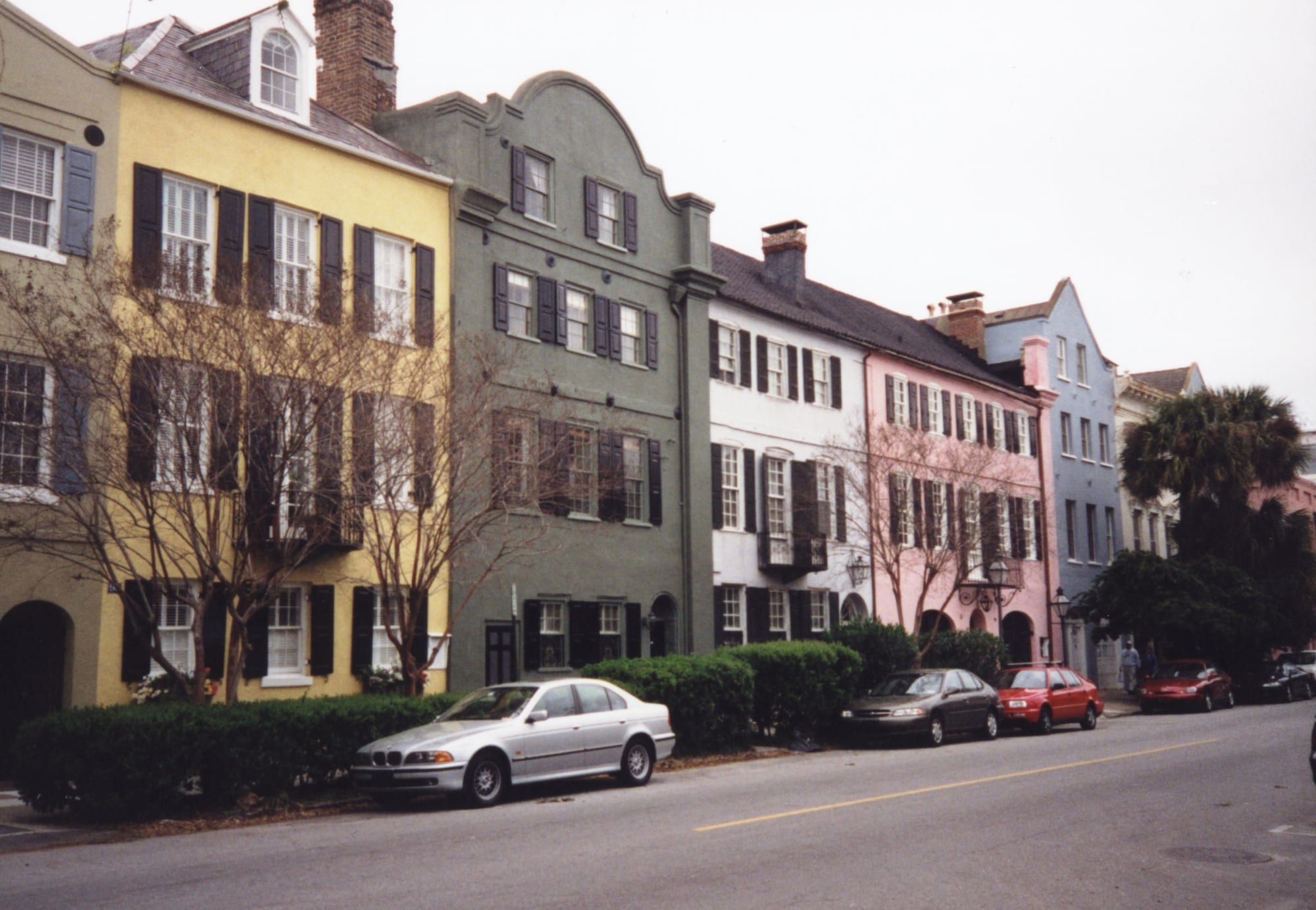
A row of three-storey townhouses painted yellow, grey-green, white, pink and blue, with dark shutters and parked cars

The South, United States

Charleston

Rainbow Row, the pastel houses of East Bay Street in Charleston's historic district. (Andreas Hörstemeier / Wikimedia Commons · CC BY-SA 3.0)

South Carolina's largest city, on a peninsula where the Ashley and Cooper rivers meet Charleston Harbor, founded by the English in 1670 and grown rich on rice, cotton and the slave trade. Its historic district of church spires, pastel townhouses and walled gardens survived fire, war, earthquake and hurricane, and today it is a busy port, aerospace centre and a centre of tourism.

Neighbourhoods

  • South of Broad
    • First-time visitors
    • Historic district
    • Architecture

    The southern tip of the peninsula below Broad Street, a quiet grid of 18th- and 19th-century houses and gardens. Rainbow Row lines East Bay Street, the Nathaniel Russell House stands on Meeting Street, and the Battery seawall and White Point Garden look out over the harbour.

    Open in Maps
  • French Quarter
    • Historic district
    • Museums
    • Best for food

    A historic district of downtown between Broad Street and the City Market, home to the Dock Street Theatre, the Old Slave Mart Museum on Chalmers Street and, by the Cooper River, Waterfront Park.

    Open in Maps
  • Ansonborough
    • Quiet and residential
    • Close to the market

    A residential neighbourhood of downtown, laid out on land that Captain George Anson acquired in 1726, with streets named after him and his ships.

    Open in Maps
  • Wraggborough and the upper peninsula
    • Museums
    • Local life

    The northern part of downtown, where the Charleston Museum and the Aiken-Rhett House stand, merging into the busier, more student-filled streets around the College of Charleston and the upper peninsula.

    Open in Maps
  • Mount Pleasant
    • Families
    • Waterfront

    A large suburban town across the Cooper River, reached by the Ravenel Bridge, home to Patriots Point and the way to Sullivan's Island and Fort Moultrie. It doubled in population in the 1990s.

    Open in Maps
  • James Island and Folly Beach
    • Beaches
    • Quiet and residential

    James Island, a residential area of the city between downtown and Folly Beach, with McLeod Plantation, leads to Folly Beach, a small beach town on Folly Island.

    Open in Maps

Things to do

Historic district

  • Rainbow Rowlandmark

    Thirteen historic houses on East Bay Street, named for the pastel colours they were painted when restored in the 20th century.

    Open in Maps
  • The Battery and White Point Gardenpark

    The seawall promenade at the tip of the peninsula, where the Ashley and Cooper rivers meet, with White Point Garden's memorials and Civil War-era cannons behind it.

    Open in Maps
  • Nathaniel Russell Housemuseum

    A house built in 1808 by a wealthy merchant and slave trader, regarded as one of the most important neoclassical houses in the United States.

    Open in Maps
  • Aiken-Rhett Housemuseum

    A house museum in Wraggborough, built in 1820 by John Robinson and later associated with Governor William Aiken.

    Open in Maps
  • Emanuel AME Churchlandmark

    Mother Emanuel, founded in 1817, the oldest African Methodist Episcopal church in the country, whose congregation's history runs from Denmark Vesey's planned uprising to the shooting of nine worshippers in 2015.

    Open in Maps
  • Dock Street Theatreattraction

    A theatre opened in the 1930s on the site of America's first purpose-built theatre building, home to the Charleston Stage Company.

    Open in Maps

Museums

  • Charleston Museummuseum

    Founded in 1773 and described as the oldest museum in the United States, with history, natural history and decorative arts collections.

    Open in Maps
  • Gibbes Museum of Artmuseum

    An art museum in a Beaux Arts building of 1905 on Meeting Street, mainly American works with a Charleston or Southern connection.

    Open in Maps
  • Old Slave Mart Museummuseum

    A building of 1859 on Chalmers Street that once housed a slave-auction gallery, believed to be the last surviving one in South Carolina.

    Open in Maps

The harbour and the water

  • Fort Sumterlandmark

    The sea fort at the mouth of the harbour where the first shots of the Civil War were fired in April 1861, reached by boat tours that leave from near the National Park Service visitor centre at Liberty Square.

    Open in Maps
  • Waterfront Parkpark

    An eight-acre park along about half a mile of the Cooper River, with fountains, piers and harbour views.

    Open in Maps
  • South Carolina Aquariumattraction

    An aquarium on the harbour, opened in 2000, focused on the aquatic life of South Carolina.

    Open in Maps
  • Patriots Pointmuseum

    A naval and maritime museum in Mount Pleasant at the mouth of the Cooper River, including the aircraft carrier USS Yorktown.

    Open in Maps
  • Arthur Ravenel Jr. Bridgelandmark

    The cable-stayed bridge to Mount Pleasant, with a main span of 1,546 feet, linking downtown with Mount Pleasant across the Cooper River.

    Open in Maps
  • Fort Moultrielandmark

    Forts on Sullivan's Island guarding the harbour; the first, built of palmetto logs, gave South Carolina its flag and its nickname, the Palmetto State.

    Open in Maps

Short trips from the city

  • Charles Towne Landingpark

    A state historic site in West Ashley on the original site of the first permanent English settlement in Carolina, founded in 1670.

    Open in Maps
  • McLeod Plantationmuseum

    A former Sea Island cotton plantation on James Island, preserved as an important Gullah Geechee heritage site.

    Open in Maps
  • Magnolia Plantation and Gardenspark

    A plantation on the Ashley River dating to 1679 and still owned by the Drayton family, known for its gardens.

    Open in Maps
  • Middleton Placepark

    A plantation about 15 miles north-west of downtown on the Ashley River, built in phases in the 18th and 19th centuries, with formal gardens.

    Open in Maps
  • Drayton Halllandmark

    An 18th-century Palladian plantation house on the Ashley River, built for John Drayton after he bought the land in 1738, and the only plantation house on the river to survive both the Revolutionary and Civil wars intact.

    Open in Maps
  • Angel Oakpark

    A southern live oak on Johns Island estimated at 400–500 years old, whose spreading branches shade about 17,200 square feet.

    Open in Maps

Seasonal events

  • Spoleto Festival USAlate spring

    A 17-day performing arts festival founded in 1977 by the composer Gian Carlo Menotti as a counterpart to the Festival of Two Worlds in Spoleto, Italy, with more than 150 performances.

  • Piccolo Spoletolate spring, alongside Spoleto

    A companion festival of local performers and artists, with hundreds of performances across the city.

  • Cooper River Bridge Runearly April

    A 10-kilometre (6.2-mile) road race across the Ravenel Bridge between Mount Pleasant and Charleston, traditionally held on the first Saturday in April; it ran every year until 2019 and was held again in September 2021 and April 2022.

Eat and drink

Long-standing places and food districts in Charleston. Hours, ratings and directions come from your maps app, always current.

Charleston classics

  • Bowen's Island Restaurantrestaurant

    A restaurant serving Lowcountry cuisine, named one of America's Classics by the James Beard Foundation in 2006.

    Open in Maps
  • Downtown Lowcountry restaurantsneighborhood

    The peninsula's restaurants serve shrimp and grits, she-crab soup, fried oysters and red rice, from old-fashioned dining rooms to new kitchens.

    Open in Maps

Markets

  • City Marketmarket

    Market sheds established in the 1790s that run four blocks from Market Hall on Meeting Street to East Bay Street, where vendors sell souvenirs, jewellery and Gullah sweetgrass baskets.

    Open in Maps

Experience Charleston

History

Charleston was founded by the English in 1670 as Charles Town, named after King Charles II, at Albemarle Point on the west bank of the Ashley River, and moved in 1680 to the tip of the peninsula. It became a primary entry point for enslaved Africans: almost half of the enslaved people imported into the United States arrived here. Planters paid more for captives from the "Rice Coast" of West Africa who knew how to grow rice, and their descendants became the Gullah. By 1770 the city of 11,000, half of them enslaved, was the wealthiest in the Thirteen Colonies.

The British took the city after a siege in 1780. Incorporated in 1783, it lost the state capital to Columbia in 1788 but grew richer on cotton, and it remained the only major American city with a majority-enslaved population. In 1822 members of the African Methodist Episcopal church led by Denmark Vesey planned an uprising; it was betrayed, dozens were hanged, and Black worship was later banned. A fire in 1838 led to the Greek Revival rebuilding still seen today. On 12 April 1861 Confederate guns fired on Fort Sumter, beginning the Civil War.

An earthquake in 1886 damaged 2,000 buildings. Tourism grew after the 1920s, Hurricane Hugo struck in 1989, and the naval base closed in 1996. On 17 June 2015 a white supremacist shot dead nine African American worshippers at Emanuel AME Church. In 2018 the city council formally apologised for Charleston's role in the slave trade.

Culture & Customs

Charleston calls itself the Holy City, and spires rise all over the peninsula. French Huguenot refugees settled here in the early 18th century, and Kahal Kadosh Beth Elohim, founded in 1749 by Sephardic Jews from London, is one of the oldest Jewish congregations in the country and an important site in the history of Reform Judaism. Mother Emanuel, the oldest African Methodist Episcopal church in the country, is a symbol of Black Charleston's resilience.

Gullah culture runs through the city. The Gullah creole language developed on the Sea Islands and in the Lowcountry, shaped local speech and is still spoken by some African American residents, though development since 1980 has weakened its hold. Gullah musicians had a strong influence on the early development of jazz, and sweetgrass baskets are sold in the City Market. The old Charleston accent, now fading, turns the city's name into "Chalston".

Preservation is a civic creed, and a 1920s book on the city's architecture set off the tourism that sustains it. The arts year peaks in late spring with Spoleto Festival USA, founded in 1977 by Gian Carlo Menotti, and the local Piccolo Spoleto, while the Dock Street Theatre stands on the site of America's first purpose-built theatre. The RiverDogs play minor league baseball, and a major women's tennis tournament is held on Daniel Island.

Daily Life

About 150,000 people lived in Charleston at the 2020 census, and about 850,000 in the three-county metropolitan area in 2023, which also includes North Charleston, Mount Pleasant and Summerville. The city has spread far beyond the peninsula: West Ashley, James Island, Johns Island, Daniel Island and the Cainhoy peninsula are all inside the city limits, while North Charleston blocks it to the north.

The economy rests on tourism, the port, one of the busiest in the country, aerospace — Boeing builds aircraft in the area — and a technology sector that has earned the nickname "Silicon Harbor". The joint military base north of the city, renamed Joint Base Lindsey Graham in August 2026, serves more than 90,000 service members, civilians, dependants and retirees. After being majority-minority for most of its history, the old city has gentrified since the late 20th century, as many white residents returned to the urban core and prices and rents rose.

Life is shaped by water and weather: tides, marshes and bridges, summer storms and the threat of hurricanes. The peninsula's streets fill with visitors and College of Charleston students, while most residents live in the suburbs and commute by car.

Food

Charleston's cooking is Lowcountry food, shaped by British, French and Gullah influences. Its signature dishes include shrimp and grits; she-crab soup, a creamy soup of blue crab; fried oysters; deviled crab cakes; red rice; and frogmore stew, a boil of shrimp, sausage, corn and potatoes. Oysters, blue crab, shrimp, flounder, redfish and black sea bass come from the estuaries and marshes around the city.

Gullah Geechee foodways remain at the heart of the cuisine through staples such as Carolina Gold rice, okra, field peas and benne, or sesame, seeds, all reflecting the agricultural knowledge brought by enslaved West Africans. Rice was the crop that built the colony's wealth, and it is still central to the table.

The downtown peninsula is known for its restaurants, from long-established dining rooms to modern kitchens, while Bowen's Island Restaurant, a James Beard "America's Classic", serves Lowcountry seafood. The City Market, open since the 1790s, now sells souvenirs, jewellery and Gullah sweetgrass baskets.

Planning tools

Budget

Charleston is one of the dearer cities in the South: hotels and inns in the historic district are expensive, especially in spring and at weekends, and prices fall in the suburbs and in high summer. Walking the historic district, the Battery and the waterfront parks costs nothing; house museums, plantation gardens and the Fort Sumter boat each charge admission.

Daily Budget Midrange
USD 230–420 (historic-district inn or hotel, Lowcountry dinners with tax and tip, house museums and the Fort Sumter boat, taxis or a hire car)
Daily Budget Shoestring
USD 100–170 (budget motel outside the peninsula, casual seafood and shrimp-and-grits lunches, buses)

Stay midweek or outside the peninsula to save on rooms, and plan a car for the plantations and beaches.

Best Time to Visit

Spring is the favourite season, with flowering gardens, mild weather and Spoleto in late spring; autumn is also warm and pleasant. Summer is hot and humid with frequent thunderstorms, and hurricanes are a major threat in summer and early autumn. Winters are mild, with snow very rare.

Suggested Number of Days

Two or three days suit most first visits to the city itself. Allow four or five to add the plantations along the Ashley River, the sea islands and the beaches. Festival dates and summer heat change the pace more than the sights do.

First Visit
2–3 days
With Surroundings
4–5 days

Transportation

The historic peninsula is compact. CARTA runs the city buses, including the Downtown Area Shuttle trolley buses that link the main sights and hotels. A car is needed for the plantations, Folly Beach and the outer islands, and the bridges carry heavy traffic at rush hours. Taxis and ride-hailing are widely used.

Parking downtown is limited — use a garage and walk.

Airport & Station Connections

Charleston International Airport, South Carolina's busiest, is in North Charleston about 12 miles north-west of downtown and shares its runways with the air base. Amtrak's Palmetto and Silver Meteor stop at a station in North Charleston about 7.5 miles from downtown. Drivers arrive on I-26, which begins downtown and links the city with I-95 and Columbia.

Walkability

The historic district is easy to explore on foot, a flat grid of narrow streets, alleys and gardens from the Battery to the City Market and beyond. Pavements can be uneven brick or flagstone, and summer heat and sudden storms make midday walking hard work. The suburbs, beaches and plantations are spread out and need wheels.

Safety

For most visitors the US is safe, with the main risks being petty theft and car break-ins in tourist areas of some cities, road accidents over long distances, extreme weather, and the hazards of the outdoors. Charleston's historic district and waterfront are busy and well used. Hurricanes, summer heat and thunderstorms, and rip currents on the beaches are the main natural hazards.

Leave nothing visible in parked cars, swim only where lifeguards are on duty, and follow evacuation orders in hurricane season. Check current official travel advice before travelling.

Climate

A humid subtropical climate with mild winters, hot, humid summers and rainfall all year. Downtown is milder than the airport because of the sea. Measurable snow falls only about once a decade. Hurricanes are a major threat in summer and early autumn; Hugo, a category 4 storm, struck in September 1989.

Summer
hot and humid, with frequent thunderstorms; the record high at the airport is 105°F
Winter
mild — the average January low is about 44°F downtown and 39°F at the airport, and measurable snow falls only about once a decade

Local Customs

Tipping of roughly 18–22 per cent in restaurants is expected. Southern courtesy matters: 'sir' and 'ma'am', greetings to strangers and an unhurried pace. The city calls itself the Holy City for its many churches, and many old natives pronounce its name 'Chalston'. Sweetgrass baskets are an important Gullah craft tradition.

Mother Emanuel and the other churches are active places of worship — visit respectfully and not during services unless attending. Many historic houses are private homes: admire them from the street.

Common Payment Methods

The currency is the US dollar. Cards and contactless payment are accepted almost everywhere; cash is handy for market stalls, basket makers and tips.