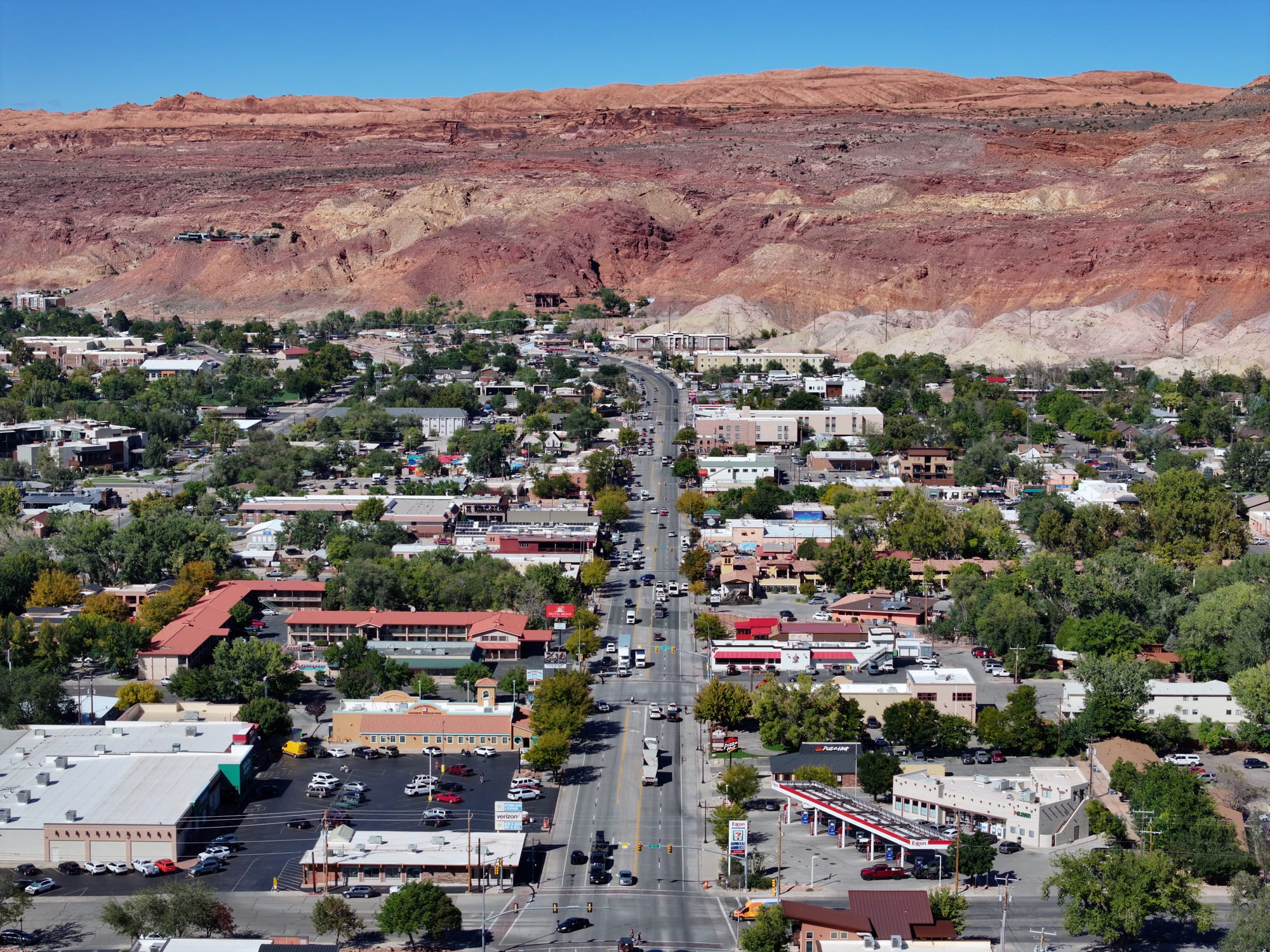
Moab's Main Street running through low buildings and green trees towards layered red and white sandstone cliffs

The Rocky Mountains, United States

Moab

Main Street in Moab, Utah, looking north towards the red rock cliffs above the town. (Quintin Soloviev / Wikimedia Commons · CC BY 4.0)

A small desert town on the Colorado River in eastern Utah, surrounded by red sandstone cliffs and mesas. Once a river crossing and then the uranium capital of the 1950s, it now lives from visitors bound for Arches and Canyonlands national parks and from the mountain bikers, off-roaders, climbers and river rafters who fill its single main street.

Neighbourhoods

  • Main Street and downtown
    • First-time visitors
    • Restaurants and outfitters
    • Close to Arches

    Moab's centre is one long main street, part of US Route 191, lined with outfitters, gear and Jeep rental shops, restaurants, motels and galleries. The local museum is a block away, and the road north leads straight to the Arches entrance.

    Open in Maps
  • Spanish Valley
    • Quiet and residential
    • Vineyards

    The valley that continues south of the town along US Route 191, mostly residential and quieter than the centre, between the red cliffs.

    Open in Maps
  • Castle Valley
    • Scenery
    • Quiet

    A tiny town about 16 miles north-east of Moab off State Route 128, named after the castle-like rock towers above it, reached on one of the region's most scenic river roads.

    Open in Maps

Things to do

Town and trails

  • Museum of Moabmuseum

    The town museum near Main Street, formerly the Dan O'Laurie Museum, with exhibits on the area's geology, dinosaurs, mining history and Native peoples.

    Open in Maps
  • Slickrock Trailtrail

    A popular 10.5-mile mountain-biking trail over petrified sand dunes a few miles north-east of town, rated one of the more difficult rides in the Moab area.

    Open in Maps
  • Corona Archtrail

    A large sandstone arch in a side canyon of the Colorado River west of Moab, reached by a 1.5-mile trail from Potash Road.

    Open in Maps
  • Fisher Towersviewpoint

    Tall towers of red sandstone caked in mud above the Colorado River north-east of town, famous with photographers and climbers, and a destination for river rafting trips.

    Open in Maps

Short trips from the town

  • Arches National Parkpark

    A park of more than 2,000 natural sandstone arches, including Delicate Arch, 4 miles north of Moab; it became a national park in 1971.

    Open in Maps
  • Dead Horse Point State Parkviewpoint

    A state park opened in 1959 on a high mesa top, with a dramatic overlook of the Colorado River and Canyonlands National Park.

    Open in Maps
  • Canyonlands National Parkpark

    A park of canyons, mesas and buttes carved by the Colorado and Green rivers, created in 1964; its Island in the Sky district looks down into the canyons from a high mesa.

    Open in Maps

Seasonal events

  • Moab Jeep SafariEaster, for nine days

    An off-road gathering run by a local four-wheel-drive club, when Jeeps and trucks take on the backcountry trails around town.

  • Skinny Tire FestivalMarch

    A road-cycling festival that raises money for cancer research and survivors.

  • Moab Music FestivalSeptember

    A music festival founded in 1992 by a group of New York musicians.

  • Moab Folk FestivalNovember

    Concerts by numerous folk musicians each November.

Eat and drink

Long-standing places and food districts in Moab. Hours, ratings and directions come from your maps app, always current.

Moab classics

  • Moab Breweryrestaurant

    A brewpub on Main Street, serving food and its own beer since 1996.

    Open in Maps
  • Spanish Valley Vineyardsrestaurant

    A local winery making Cabernet Sauvignon, Syrah, Riesling and Gewürztraminer, whose bottles appear on Moab restaurant menus.

    Open in Maps

Food districts

  • Main Street restaurantsneighborhood

    Many of the town's restaurants, cafés and bars line Main Street and the blocks just off it, from pizza and pasta to burgers and sports bars.

    Open in Maps

Experience Moab

History

The canyon country was home to Native peoples long before settlers arrived, and the Ute were living here when they came. Between 1829 and the early 1850s the site of the town was the Colorado River crossing on the Old Spanish Trail. In 1855 Latter-day Saint settlers built a trading fort there, the Elk Mountain Mission, but abandoned it after repeated attacks. The first lasting non-Native settler was William Grandstaff, a mixed-race cowboy who arrived in 1877 and ranched cattle in a nearby canyon; Mormon families followed from 1878, and racial hostility drove Grandstaff out in 1881. Residents chose the biblical name Moab in 1880, and the town was incorporated in 1902.

The railway built across eastern Utah in 1883 passed far to the north, and Moab settled into farming and then mining. In 1943 a former Civilian Conservation Corps camp outside town became an isolation centre for Japanese Americans labelled troublemakers in the wartime camps. In the 1950s the geologist Charles Steen found a rich uranium deposit south of town, and Moab became the self-styled "Uranium Capital of the World", its population growing by nearly 500 per cent. When the Cold War wound down the mines closed, and by the early 1980s many homes stood empty; a huge pile of uranium mill tailings beside the river has been moved away by rail since 2009.

Tourism took over. John Ford filmed Wagon Master here in 1949, beginning a long film history; Arches, a national monument since 1929, became a national park in 1971, and Canyonlands was created in 1964. Mountain bikers and off-roaders have since made the town a popular base.

Culture & Customs

Moab's culture is built on the outdoors. The Slickrock Trail made it a popular base for mountain bikers, the Jeep Safari fills it with off-road vehicles every Easter, and climbers, canyoneers, river guides, skydivers and BASE jumpers all base themselves here. Outfitters, rental shops and guide services occupy much of Main Street, and many residents work as guides.

The desert has also drawn writers and film-makers. Edward Abbey based Desert Solitaire, published in 1968, on his seasons as a ranger at Arches, near Moab, and Moab's film commission, founded in 1949, claims to be the longest-running in the world, having overseen westerns, Indiana Jones and the Last Crusade, Thelma and Louise and Mission: Impossible 2.

There is more culture than the town's size suggests. The Moab Music Festival, founded in 1992, takes place each September, the folk festival comes in November, a road-cycling festival raises money for cancer research and survivors in March, and an LGBT Pride festival has been held since 2011. A regular art walk shows local artists' work.

Daily Life

Moab had 5,366 people at the 2020 census. It is the largest town and the county seat of Grand County, covering under 5 square miles on the south bank of the Colorado River at 4,025 feet, and home to a regional campus of Utah State University. The town is tightly hemmed in by cliffs and public land, which is used for grazing, drilling and forestry as well as recreation.

Tourism is the economy now that uranium is gone: motels, restaurants, outfitters and guide services employ much of the town, and visitor numbers rise and fall with the seasons — busiest in spring and autumn, slower in the heat of summer and quiet in winter. Housing is a pressing local issue: many residents fear changes like those in the Colorado resorts of Vail and Aspen — soaring property values, a rising cost of living and the strain on workers on low and middle incomes.

Daily life is small-town and outdoors-oriented: early-morning rides and runs before the heat, river trips, and evenings on the patios of Main Street. A free weekly paper, the Moab Sun News, covers local affairs.

Food

Moab's food is ordinary small-town American, shaped by hungry cyclists and hikers: pizza, pasta, burgers, Mexican food and big breakfasts, served along Main Street, where many of the town's restaurants stand within a short walk of one another. There is no single signature dish; Utah's statewide favourites include fry sauce, a mix of ketchup and mayonnaise for chips, and the drive-through soda shops that mix fizzy drinks with syrups and cream.

Local drink is the bigger story. The Moab Brewery has made beer on Main Street since 1996, and Spanish Valley Vineyards grows Cabernet Sauvignon, Syrah, Riesling and Gewürztraminer in the desert, its bottles sold at the town's liquor store and poured in local restaurants. Utah's alcohol rules are strict: stronger drinks are sold in state-run stores, which shapes how and where people buy wine and spirits.

For backcountry trips, self-catering is the norm, and outfitters and campers stock up at the town's supermarkets before heading out with plenty of water.

Planning tools

Budget

Rooms in Moab are dear, especially in spring and autumn, the busy seasons, and during the Jeep Safari at Easter. Food is ordinary small-town American and priced accordingly. Guided trips — rafting, canyoneering, Jeep tours — and vehicle rental add most to the bill.

Daily Budget Midrange
USD 220–400 (motel or mid-range hotel, restaurant meals, rental car and fuel, park entry or a guided trip)
Daily Budget Shoestring
USD 90–150 (campground or budget motel, supermarket food, a shared car)

An annual national-parks pass covers Arches and Canyonlands but not Dead Horse Point, a state park; the Main Street shops and many trails cost nothing.

Best Time to Visit

Spring (March to May) and autumn (September to October) are best, before and after the summer heat, and are also the busiest seasons. In summer temperatures pass 100°F on many days and walking is best early and late. Winter is quiet and mild by day, with frosty nights and only a little snow.

Suggested Number of Days

Two or three days give time for both national parks. Allow four or five for a river trip, a mountain-bike ride or a four-wheel-drive trail as well. Summer heat shortens the useful hours of each day, which can add time.

First Visit
2–3 days
With Surroundings
4–5 days

Transportation

Main Street, part of US Route 191, runs through the centre and north to Arches, the airport and Interstate 70. A car is effectively essential for the parks; Jeep and other four-wheel-drive rentals are available for the backcountry roads, and many outfitters provide transport on guided trips. Cycling is popular, but drivers should watch for bicycles on the roads near town.

Do not drive the river road, State Route 128, at night; take US 191 instead after dark.

Airport & Station Connections

Canyonlands Regional Airport, 21 miles north-west of Moab, has small commuter flights. Many visitors fly to Salt Lake City, Denver or Grand Junction and drive. Salt Lake Express buses run to Salt Lake City in roughly four and a half hours, and the nearest Amtrak stop, on the California Zephyr, is at Green River, about 52 miles away.

Walkability

The centre is a long, walkable strip along Main Street, and a small town museum, restaurants and outfitters sit within a few blocks of each other. Everything beyond town needs a car, a bicycle or a tour, and summer heat makes midday walking hard.

Safety

The main dangers are those of the desert: extreme summer heat and dehydration, flash floods in slot canyons after rain, falls from sandstone ledges, and getting stranded on remote dirt roads.

For most visitors the US is safe, with the main risks being petty theft and car break-ins in tourist areas of some cities, road accidents over long distances, extreme weather, and the hazards of the outdoors. Carry at least a gallon of water per person per day on backcountry trips, never enter a slot canyon when rain is forecast, and check with the park service for any entry reservations in force. Check current official travel advice before travelling.

Climate

A semi-arid climate bordering on desert, at 4,025 feet, with hot summers, chilly winters and only about 9 inches of rain a year, spread evenly across the months.

Summer
very hot — on average 41 days a year reach 100°F and 109 days reach 90°F; the record is 114°F
Winter
chilly nights and mild days, with only a few days a year staying at or below freezing and about 7 inches of snow; the record low is −24°F

Local Customs

Moab is relaxed and outdoorsy; dress is casual everywhere. Tipping of around 18–22 per cent is expected in restaurants and for guides. Utah's liquor laws are some of the most restrictive in the United States, and stronger drinks are sold in state-run stores. Desert soils are fragile, so staying on trails and slickrock is expected.

Identification is asked for when buying alcohol (the legal age is 21). Do not touch or climb on rock art, and leave cultural sites as they are found.

Common Payment Methods

The currency is the US dollar. Cards and contactless payment are accepted almost everywhere in town, and ATMs are easy to find on Main Street. Sales tax is added at the till, and a little cash is useful for tipping guides.