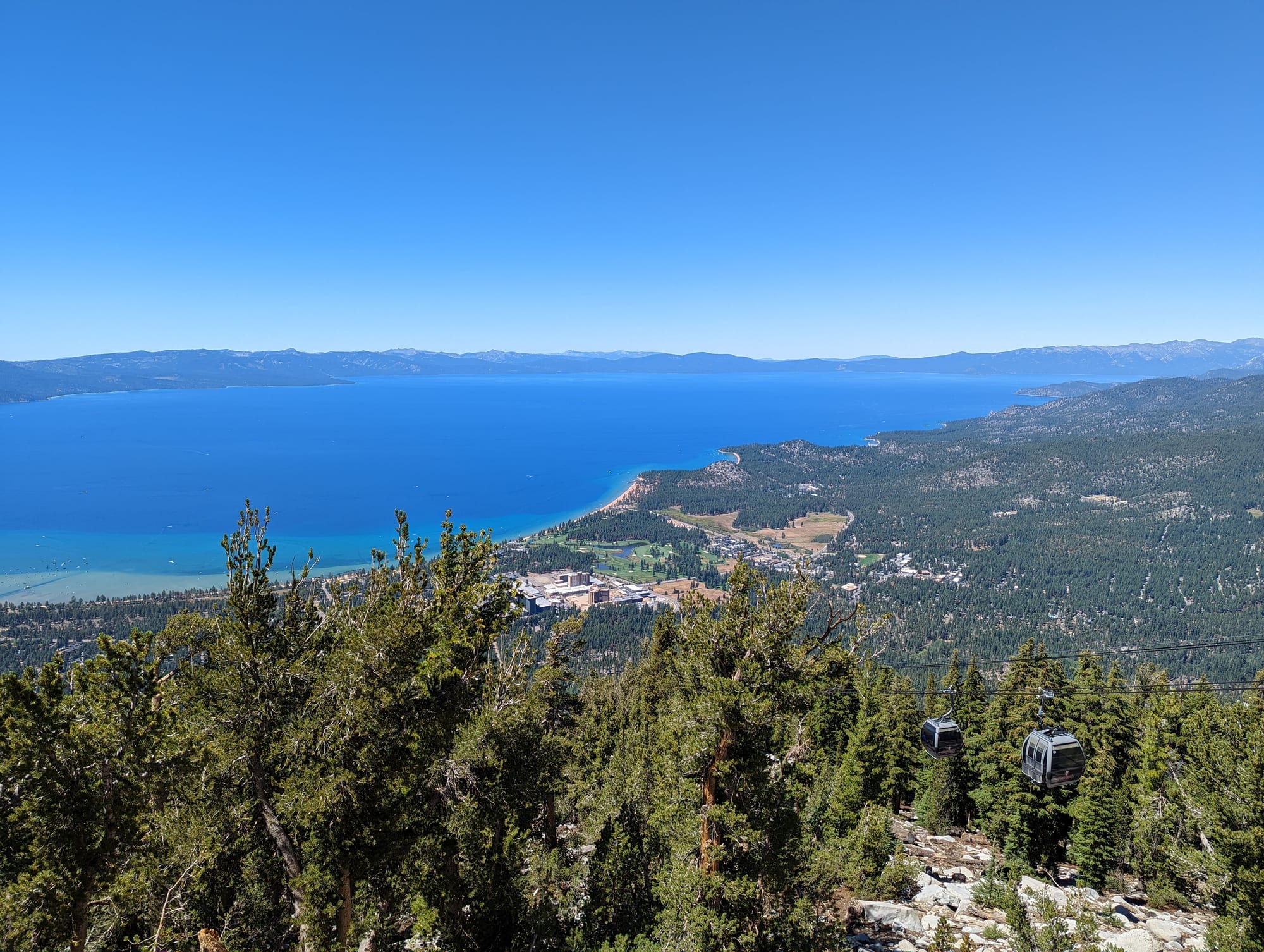
Deep blue Lake Tahoe seen from a forested mountainside, with the south shore town, a sandy beach and gondola cabins below

California, United States

South Lake Tahoe

Lake Tahoe and the south shore from the observation deck on Heavenly's gondola, above South Lake Tahoe and Stateline. (Blake Everett Carroll / Wikimedia Commons · CC BY-SA 4.0)

A mountain resort city of about 21,000 people on the southern shore of Lake Tahoe, at some 6,200 feet in the Sierra Nevada, pressed against the Nevada state line. Formed in 1965 from a string of lakeside communities, it lives on skiing at Heavenly in winter, beaches and trails in summer, and the casinos of Stateline just across the border.

Neighbourhoods

  • Heavenly Village and the state line
    • First-time visitors
    • Skiing
    • Nightlife

    The busy eastern end of town at the foot of Heavenly's gondola, with shops, restaurants, bars and large hotels. A block away the state line crosses Highway 50 into Stateline, Nevada, and the casinos, so most of what visitors need is within a few minutes' walk.

    Open in Maps
  • Lake Tahoe Boulevard
    • Budget stays
    • Beaches
    • Local life

    Highway 50 runs about five miles west from the state line through the old communities of Bijou and Al Tahoe, lined with motels, small businesses, restaurants and access to the beaches and the lakeside park at Lakeview Commons.

    Open in Maps
  • The Y and the west side
    • Quiet and residential
    • Close to trails

    The mainly residential western end of the city, around the junction of Highway 50 and Highway 89 known as the Y, where the road turns off towards Emerald Bay and the west shore.

    Open in Maps
  • Tahoe Keys
    • Boating
    • Quiet and residential
    • Holiday rentals

    A private marina community at the southern tip of the lake, laced with about eleven miles of inland waterways, where most homes have their own boat dock.

    Open in Maps
  • Camp Richardson and the south-west shore
    • Beaches
    • Historic estates
    • Cycling

    A lakeside resort community just west of the city, founded in 1921, with a marina, cabins, beaches and a bar and grill, beside the historic Pope Estate and near the mouth of Taylor Creek.

    Open in Maps

Things to do

The lake and its shore

  • Lake Tahoeattraction

    The largest alpine lake in North America and, at 1,645 feet, the second-deepest in the United States, known for the clarity of its water and the mountains around it on every side.

    Open in Maps
  • Pope Estatelandmark

    A historic wood-and-shingle summer home of the 1880s near Camp Richardson, built by Lloyd Tevis and used by the Tevis and Pope families, with its servants' cabins still on the grounds.

    Open in Maps
  • Taylor Creekpark

    A short stream flowing from Fallen Leaf Lake to Baldwin Beach on Lake Tahoe, through meadows where beavers have been studied for their effect on the lake's water.

    Open in Maps
  • Fallen Leaf Lakepark

    A glacier-carved lake about three miles long, a mile south-west of Lake Tahoe, held in place by a moraine that stopped it becoming a bay of the larger lake.

    Open in Maps

Mountains and trails

  • Heavenly Mountain Resortattraction

    The ski area on the California–Nevada border above town, opened in 1955, with 97 runs and 30 lifts and the highest elevation of the Tahoe resorts; its gondola runs from Heavenly Village and gives wide views of the lake.

    Open in Maps
  • Van Sickle Bi-State Parkpark

    A park straddling the state line just above the casinos, with hiking, mountain-biking and riding trails overlooking the lake.

    Open in Maps
  • Tahoe Rim Trailtrail

    A 170-mile hiking trail looping right round the Lake Tahoe Basin, with sections reached from trailheads near the south shore.

    Open in Maps
  • Desolation Wildernesspark

    A protected wilderness of granite peaks and lakes along the Sierra crest just west of the lake, reached on foot from trailheads west of the lake; the Tahoe Rim Trail passes through it.

    Open in Maps

Emerald Bay

  • Emerald Bay State Parkpark

    A glacier-carved bay on the south-west shore, a National Natural Landmark, with Eagle Falls and Fannette Island, the only island in Lake Tahoe, reached along Highway 89.

    Open in Maps
  • Vikingsholmlandmark

    A 38-room mansion on the shore of Emerald Bay, called one of the finest examples of Scandinavian architecture in North America.

    Open in Maps

Stateline and the ski areas beyond

  • Stateline, Nevadaneighborhood

    The small Nevada community directly across the state line, where large casino hotels line Highway 50 within walking distance of Heavenly Village.

    Open in Maps
  • Sierra-at-Tahoeattraction

    A medium-sized, family-oriented ski area about 12 miles south-west of the city on Highway 50, known for its heavy snowfall.

    Open in Maps
  • Kirkwood Mountain Resortattraction

    A ski area about 33 miles south of the city on Highway 88, used for hiking and mountain-biking in summer.

    Open in Maps

Eat and drink

Long-standing places and food districts in South Lake Tahoe. Hours, ratings and directions come from your maps app, always current.

Food districts

  • Heavenly Villageneighborhood

    The town's main cluster of restaurants, pizzerias, bars and a brewery at the foot of the gondola, busy all year with skiers and summer visitors.

    Open in Maps
  • Lake Tahoe Boulevardneighborhood

    The main road through town, with casual places to eat — Mexican, Greek, Hawaiian, barbecue and breakfast diners — some with views across the road to the lake.

    Open in Maps
  • Camp Richardsonneighborhood

    A lakeside resort with a bar and grill and a beach bar, where people eat outdoors with a view of the water in summer.

    Open in Maps

Experience South Lake Tahoe

History

Lake Tahoe was the centre of the Washoe homeland, and its name comes from the Washoe word dáʔaw, "the lake". The Washoe came up to the lake in summer to fish for Lahontan cutthroat trout and gather clams, and moved in autumn to the pine-nut hills and the western Sierra slopes for piñon nuts and acorns. John C. Frémont became the first European-American to see the lake on 14 February 1844. The discovery of the Comstock Lode in 1858–59, 15 miles to the east, transformed the basin: from then until about 1890 loggers stripped its forests for timber to shore up the silver mines of Virginia City, and settlers displaced the Washoe from their ancestral lands.

As the mines declined, wealthy families built summer estates on the shore, some of which survive near Camp Richardson and Emerald Bay. One of the area's first gambling halls opened on the Nevada side in 1944, more casinos followed in the 1950s, roads began to be ploughed year-round, Heavenly Valley opened for skiing in 1955, and the 1960 Winter Olympics on the north shore made Tahoe the skiing centre of the western United States. In 1965 the communities of Al Tahoe, Bijou, Bijou Park, Stateline, Tahoe Valley and Tallac Village joined to incorporate as the city of South Lake Tahoe.

Rapid growth brought pressure on the lake, whose famous clarity has declined as nutrients and fine sediment reach the water. Fire is the other modern threat. The Angora Fire of June 2007, the worst forest fire in the lake's recorded history, damaged or destroyed more than 275 buildings near Meyers, and in August 2021 the Caldor Fire crossed the Sierra crest and forced the evacuation of the entire city before its advance was halted. In 2012 a lakeside park was given the Washoe name Tahnu Leweh, "all the people's place".

Culture & Customs

South Lake Tahoe is a resort town with two personalities. In winter it is a ski town, organised around Heavenly's lifts and gondola and the other south-shore areas of Sierra-at-Tahoe and Kirkwood, with snowboarders and skiers filling the buses, bars and rental shops. In summer the lake takes over: beaches, boats, paddleboards, mountain bikes and the trails of the Tahoe Rim Trail and Desolation Wilderness. Spring and autumn, the shoulder seasons, are when the town belongs mostly to its residents.

The state line gives the place its peculiar character. On the Nevada side, Stateline's casinos, built up from the 1950s, bring entertainment, shows and late nights; on the California side, a step away, the city is a low-rise town of motels, cabins and pine woods. Visitors move between the two without noticing the border except in the change of buildings and laws.

The Washoe, for whom the lake is both the geographical and spiritual centre of their world, remain part of its life through the Washoe Tribe of Nevada and California, and the protection of the lake — its clarity, its forests, its native fish — is a cause shared across the community, from scientists to residents and businesses.

Daily Life

The city had about 21,300 people at the 2020 census, slightly fewer than in 2010. The figures show the shape of a resort town: more than two-fifths of homes were vacant at the census, many of them second homes and holiday rentals, and around three in five occupied homes were rented. The population rises sharply in the ski and summer seasons, and adjoining Stateline has only a few hundred permanent residents but a great many hotel rooms.

Tourism drives the economy — skiing, the casinos, hotels, restaurants and outdoor recreation — with Lake Tahoe Community College, at about 6,200 feet the highest college in California, and local schools and services alongside. The eastern end of town is geared to visitors, while residents live mostly around the Y, the Tahoe Keys and the side streets off the highway. In 2024 the city began working with El Dorado County on a new joint transit agency to add to the existing bus service.

Daily life follows the snow. Residents plough driveways, fit chains and watch road reports through the winter, and the town fills with traffic on holiday weekends. Summer and autumn bring the fear of wildfire, which forced evacuations in 2007 and 2021.

Food

The first food of the lake was Washoe food: Lahontan cutthroat trout and freshwater clams in summer, then piñon nuts gathered in the hills and acorns from the western Sierra slopes in autumn. The native trout were wiped out in the lake in the early 20th century by introduced fish, and efforts to bring them back began in 2019; lake trout, rainbow trout and sockeye salmon, all introduced, are now the fish of local anglers.

Today South Lake Tahoe eats like a mountain resort. Heavenly Village has pizzerias, bars, a brewery and casual restaurants at the foot of the gondola, busy with skiers in winter and walkers in summer, and the casinos across the state line have their own restaurants and bars. Along Lake Tahoe Boulevard are the everyday places locals use — Mexican restaurants serving tacos, burritos and aguas frescas such as horchata and hibiscus, Greek gyros and souvlaki, Hawaiian food, barbecue and breakfast diners.

In summer, eating moves outdoors. Lakeside bars and grills at Camp Richardson and elsewhere along the shore serve food and drinks on decks above the water, and sunset over the lake is the busiest hour on any rooftop or terrace with a view.

Planning tools

Budget

Costs depend on the season. Ski weekends and holiday weeks in winter and the summer peak bring the highest room prices, and lift tickets are the biggest single expense of a winter trip. Spring and autumn, between the seasons, are much cheaper. Many visitors stay in holiday rentals or motels along Lake Tahoe Boulevard rather than in the large hotels at the state line.

Daily Budget Midrange
USD 250–480 (mid-range hotel or rental, restaurants with tax and tips, a lift ticket or boat hire, a hire car)
Daily Budget Shoestring
USD 110–180 (motel or hostel bed, takeaway food and supermarkets, local buses, beaches and trails)

Book well ahead for holiday weeks and summer weekends, and consider staying between the seasons for lower prices.

Best Time to Visit

Winter, roughly mid-November to mid-April, is the ski season, with Heavenly averaging hundreds of inches of snow. Summer is the season for beaches, boating, hiking and cycling, with warm, dry days and cold nights. Late summer and autumn bring the highest wildfire risk and occasional smoke, while late spring and autumn are the quietest and cheapest times.

Suggested Number of Days

Two or three days are enough for a first look at the south shore. A ski trip or a summer stay with hiking usually runs four to six days, and winter road closures and snow can add time to any visit.

First Visit
2–3 days
With Surroundings
4–6 days

Transportation

The city stretches about five miles along Highway 50, so most visitors use a car. Local buses run along the shore, and in winter the ski areas run their own free shuttles. Around Heavenly Village and the casinos everything is within about a quarter of a mile. Cycling is popular in summer. Highway 50 often closes in bad winter weather.

In winter carry chains or have a four-wheel-drive vehicle with snow tyres: chain controls are common, and roads close during heavy snow.

Airport & Station Connections

The closest scheduled flights are at Reno–Tahoe International Airport in Nevada, the most common way in; an airport shuttle runs from Reno to the casinos at Stateline. Visitors from further afield also fly into Sacramento or San Francisco and drive up Interstate 80 or Highway 50. Lake Tahoe Airport, three miles south-west of the city, has had no airline service since 2000. El Dorado Transit buses and an Amtrak Thruway bus connect with Sacramento.

Walkability

Heavenly Village, the gondola and the Stateline casinos are close together and easy on foot, with underground walkways between some of the casinos. Elsewhere the city is long and spread out along a busy highway, and the beaches, Camp Richardson and Emerald Bay are best reached by car, bus or bike. Snow and ice make walking harder in winter, and the altitude, over 6,000 feet, makes uphill walks tiring at first.

Safety

For most visitors the US is safe, with the main risks being petty theft and car break-ins in tourist areas of some cities, road accidents over long distances, extreme weather, and the hazards of the outdoors. In South Lake Tahoe the main hazards are natural. The Angora Fire of June 2007 destroyed 254 homes nearby, and in August 2021 the whole city was evacuated as the Caldor Fire approached; winter storms bring heavy snow, chain controls and road closures; and the altitude and cold lake water catch out some visitors.

Follow fire and evacuation orders at once, check road conditions before driving in winter, drink plenty of water at altitude, and wear a life jacket when boating or paddling. Check current official travel advice before travelling.

Climate

A snowy highland climate. Winters are cold, with an average of 88 inches of snow and 223 mornings a year below freezing; summers have warm days, cool nights and very low humidity, and only about one day a year reaches 90°F. February is the wettest month and August the driest.

Summer
dry and sunny, with warm days, cool nights and only about one day a year reaching 90°F
Winter
cold and snowy, with most nights at or below 32°F

Local Customs

Tipping of roughly 18–22 per cent in restaurants is expected, and sales tax is added at the till. Dress is casual and outdoor almost everywhere. The casinos are all on the Nevada side of the line, and the two states' laws differ on a number of matters. The lake is the homeland of the Washoe people, and some places carry Washoe names, such as the lakeside park Tahnu Leweh, 'all the people's place'.

The legal drinking age is 21, and identification is asked for when buying alcohol and in the casinos. Keep food locked away from wildlife at campsites and rentals.

Common Payment Methods

The currency is the US dollar. Cards and contactless payment are accepted almost everywhere, and ATMs are easy to find, especially in the casinos. A little cash is useful for tips and small purchases.