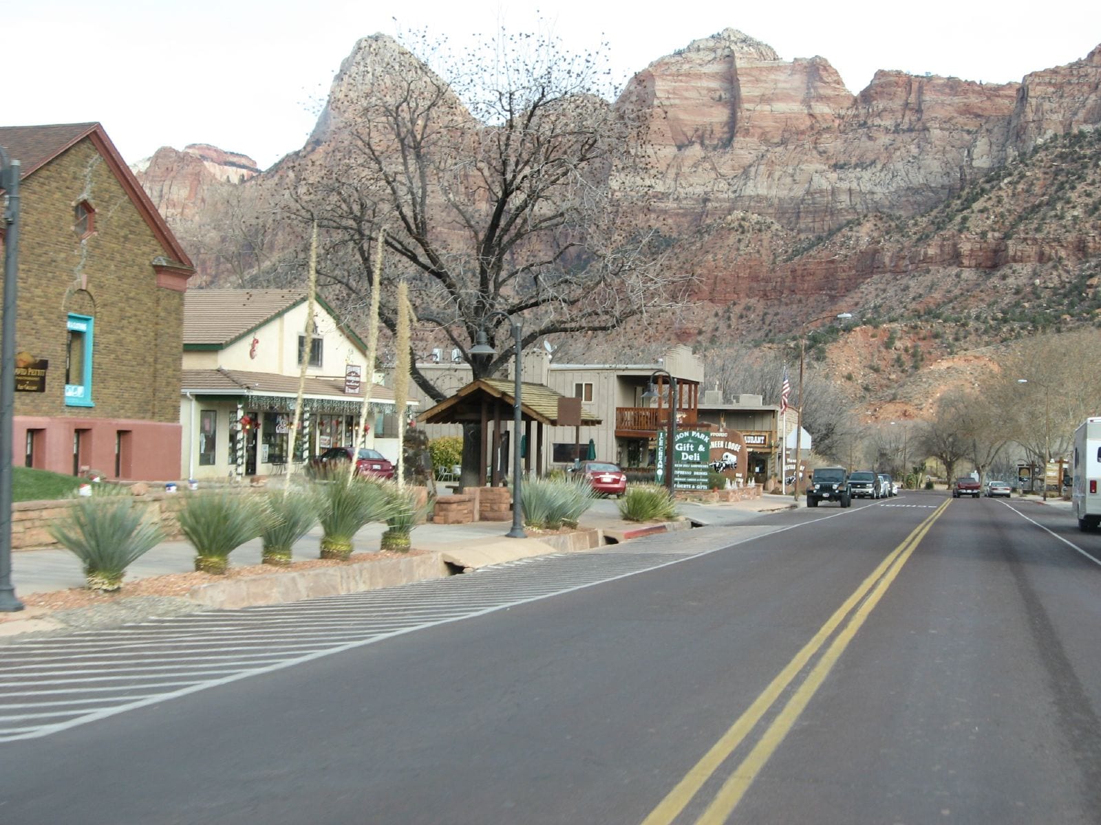
Springdale's main road lined with low shops, a gift shop and deli, and desert plants, beneath tall red and white sandstone cliffs

The Rocky Mountains, United States

Springdale

The main road through Springdale, Utah, with the cliffs of Zion National Park behind. (Ken Lund / Wikimedia Commons · CC BY-SA 2.0)

A small town of about 500 people in Zion Canyon in south-western Utah, beside the main entrance to Zion National Park. Settled by Mormon farmers in 1862 on the North Fork of the Virgin River, it now lives almost entirely from the millions who visit the park, lining a single main road beneath sandstone cliffs with lodgings, restaurants, galleries and outfitters.

Neighbourhoods

  • Zion Park Boulevard
    • First-time visitors
    • Restaurants and galleries
    • Shuttle access

    Springdale is essentially one street, State Route 9, known in town as Zion Park Boulevard. Lodgings, restaurants, galleries, outfitters and a supermarket line it, and the free town shuttle runs its length to the park entrance in season.

    Open in Maps
  • Rockville
    • Quiet
    • Scenery

    A tiny town of about 230 people along the Virgin River a few miles downstream, about five miles from the park entrance, quieter than Springdale and close to the Grafton ghost town.

    Open in Maps

Things to do

Zion National Park

  • Zion National Parkpark

    A national park created in 1919 from a 1909 national monument, a deep sandstone canyon cut by the North Fork of the Virgin River; it drew almost five million visitors in 2025.

    Open in Maps
  • The Watchmanviewpoint

    A 6,545-foot sandstone peak that rises directly above the east side of town and the park entrance.

    Open in Maps
  • Angels Landingtrail

    A 1,488-foot rock fin reached by a trail cut in 1926, whose last half-mile follows a narrow, chain-lined ridge; since 2022 hikers going beyond Scout Lookout have needed a permit.

    Open in Maps
  • The Narrowstrail

    The narrowest part of Zion Canyon, hiked up the bed of the North Fork of the Virgin River from the Temple of Sinawava at the end of the canyon road.

    Open in Maps
  • Zion – Mount Carmel Highwaylandmark

    The historic road east out of the canyon, famous for its 1.1-mile tunnel with six large windows cut through the sandstone cliff.

    Open in Maps

Short trips from the town

  • Graftonattraction

    A ghost town just south of the park near Rockville, said to be the most photographed in the West and used in films including Butch Cassidy and the Sundance Kid.

    Open in Maps

Eat and drink

Long-standing places and food districts in Springdale. Hours, ratings and directions come from your maps app, always current.

Springdale classics

  • Zion Canyon Brew Pubrestaurant

    A brewpub at the park end of the main road, near the entrance to Zion.

    Open in Maps
  • Sol Foods Marketmarket

    The town's full-service supermarket, with a deli and camping supplies, where hikers stock up before a day in the canyon.

    Open in Maps

Food districts

  • Restaurants on Zion Park Boulevardneighborhood

    Pizza and pasta, burgers, Mexican and Thai restaurants and coffee shops line the main road, most of them a short walk or shuttle ride from one another.

    Open in Maps

Experience Springdale

History

The canyon of the Virgin River was home to Basketmaker Ancestral Puebloans and later the Virgin Anasazi and Parowan Fremont, who had moved away by about 1300 and were followed by the Parrusits and other Southern Paiute groups, some of whom farmed corn, squash and sunflowers. A Southern Paiute guide led the Mormon missionary Nephi Johnson into the upper Virgin River area, and Latter-day Saint farmers followed. Springdale was settled in 1862 by families who had fled flooding at nearby Northrop, and settlers farmed the floor of Zion Canyon itself until it became a national monument in 1909.

John Wesley Powell visited in 1872 and named the canyon Mukuntuweap, believing it to be the Paiute name. President Taft proclaimed Mukuntuweap National Monument in 1909, and in 1919 Congress enlarged it as Zion National Park, adopting the name the local Mormon community used. The Zion – Mount Carmel Highway, begun in 1927, gave reliable access between Springdale and the east side of the park, and the town grew as a gateway.

Visitor numbers rose until traffic in the narrow canyon became a serious problem, and in 2000 the park introduced shuttle buses; a free shuttle route now also runs through Springdale. In 1992 the St. George earthquake destroyed three houses in the town, and a large landslide covered part of State Route 9. In 2006 the town banned chain restaurants to protect its character, but gave up defending the rule in court in 2015. In 2025 the park received almost five million visitors.

Culture & Customs

Springdale's culture is shaped by the canyon. Guide and outfitter businesses serve climbers, cyclists and hikers. Galleries along the main road sell art with Southwest themes, and shops carry Native American jewellery, baskets and other crafts from across the region. The red and white cliffs of Zion — The Watchman above town, Mount Kinesava to the west — are the backdrop to daily life and the subject of countless photographs.

Like much of southern Utah, the town has Mormon pioneer roots, and the name Zion itself comes from the language of those settlers. Today Springdale is a small resort community — the median age was 47.8 at the 2010 census — and the town has long tried to protect its independent character against the pressures of mass tourism, most visibly in its long effort to keep out chain restaurants.

Respect for the park is part of local life, and visitors are expected to use the shuttles, stay on trails and treat the fragile desert with care. The Grafton ghost town nearby, used in Butch Cassidy and the Sundance Kid, recalls the area's film history and the hard life of its early settlers.

Daily Life

Springdale had 514 people at the 2020 census. The town covers about 4.6 square miles of Zion Canyon, with the North Fork of the Virgin River running through it shortly before it meets the East Fork. Almost all of its businesses serve visitors to the park, which received almost five million in 2025.

Life follows the park's seasons. From spring to autumn shuttle buses run along the main road from early morning to late evening, motels and restaurants are full, and traffic and parking are constant concerns; in winter the town quietens. The town is governed by a mayor and council, and children attend schools of the Washington County School District, which covers the whole county.

The setting brings hazards as well as beauty. Flash floods, rockfalls and earthquakes are part of the canyon's history, and summer heat shapes the working day, with hikers setting out at dawn and returning before the hottest hours.

Food

Springdale's food is that of a busy park gateway: the main road offers pizza and pasta, burgers, Mexican and Thai cooking, coffee shops and a few finer dining rooms, all aimed at hungry hikers. Many visitors simply picnic, buying supplies at the town's supermarket and deli before boarding the shuttle into the canyon, where picnic sites are limited to a few designated places.

Utah's statewide favourites appear here as elsewhere: fry sauce, a mix of ketchup and mayonnaise for chips, and funeral potatoes, a cheesy potato bake with a crunchy topping. The town once banned chain restaurants to keep its dining local; since it dropped the rule in 2015, chains have begun to appear beside the independent places.

Drink follows Utah's strict rules: stronger drinks are sold in state-run stores, and the town's brewpub, at the park end of the main road, is a popular stop after a day of hiking.

Planning tools

Budget

Rooms in Springdale are expensive, above all from spring to autumn, when Zion is busiest. Food is ordinary American and tourist-priced. Staying a town or two further west, in Hurricane or St. George, can save money at the cost of a longer drive.

Daily Budget Midrange
USD 220–420 (motel or mid-range hotel, restaurant meals, rental car and fuel, park entry)
Daily Budget Shoestring
USD 90–150 (campground or budget motel, supermarket picnics, the free shuttles)

Book rooms months ahead for spring and autumn; the town shuttle and the park's canyon shuttle are free, and an annual national-parks pass covers park entry.

Best Time to Visit

Spring and autumn are best, with milder temperatures for hiking; in the park spring wildflowers bloom from April to June, peaking in May. Summer days are very hot, so hikes are best early or late. In winter the canyon is quieter and private cars may use the canyon road, with cold nights and occasional snow.

Suggested Number of Days

Two or three days allow time for the main canyon and one longer hike. Allow four or five to add the quieter parts of the park or a longer canyon hike as well. Permits, river levels and summer heat can all change what is possible on a given visit.

First Visit
2–3 days
With Surroundings
4–5 days

Transportation

Springdale is a one-street town, easy to walk or cycle. From about April to October a free town shuttle runs along the main road to the park entrance, where it meets the park's own free shuttle; from early April to late October the road into Zion Canyon is normally closed to private cars, and visitors ride the shuttle buses. Parking at the park visitor centre often fills, so leaving the car in town is usual.

Cycling into the park is popular; check current shuttle seasons, hours and any permit rules with the park service before travelling.

Airport & Station Connections

Most visitors drive. State Route 9 leaves Interstate 15 north of St. George and runs east through Hurricane to Springdale; from the east it comes through the park on the Zion – Mount Carmel Highway and its tunnel. St. George Regional Airport, with regional flights, is about 45 minutes away, and the nearest major airport is in Las Vegas, about 150 miles away. SunTran buses run from St. George.

Walkability

Everything in Springdale lies along the main road and is fairly close together, and the shuttle covers the rest. Summer heat makes walking in the middle of the day hard.

Safety

Crime is low. The real risks are in the park: falls from cliffs — Angels Landing has the most hiking deaths in Utah, with a fatal fall as recently as April 2026 — summer heat and dehydration, and flash floods in the narrow canyons after storms, which can be deadly.

For most visitors the US is safe, with the main risks being petty theft and car break-ins in tourist areas of some cities, road accidents over long distances, extreme weather, and the hazards of the outdoors. Never enter the Narrows or a slot canyon when rain is forecast, carry plenty of water, and hike in the cool of the morning in summer. Check current official travel advice before travelling.

Climate

A dry climate at the meeting point of the Colorado Plateau, the Great Basin and the Mojave Desert, with very hot summers, mild winters and large differences between day and night temperatures. The figures below are those given for Zion Canyon in the national park.

Summer
very hot — in Zion Canyon days typically 95–110°F, with nights usually 65–70°F
Winter
fairly mild — in Zion Canyon clear days can reach about 60°F, with nights often 20–40°F

Local Customs

Dress is casual everywhere. Tipping of around 18–22 per cent is expected in restaurants. Utah's liquor laws are the strictest in the region, and stronger drinks are sold in state-run stores. The town fought for years to keep chain restaurants out, and local businesses are a point of pride.

Identification is asked for when buying alcohol (the legal age is 21). Keep to trails, leave plants and rock art untouched, and give way to shuttle buses.

Common Payment Methods

The currency is the US dollar. Cards and contactless payment are accepted almost everywhere, and sales tax is added at the till. A little cash is useful for tips.