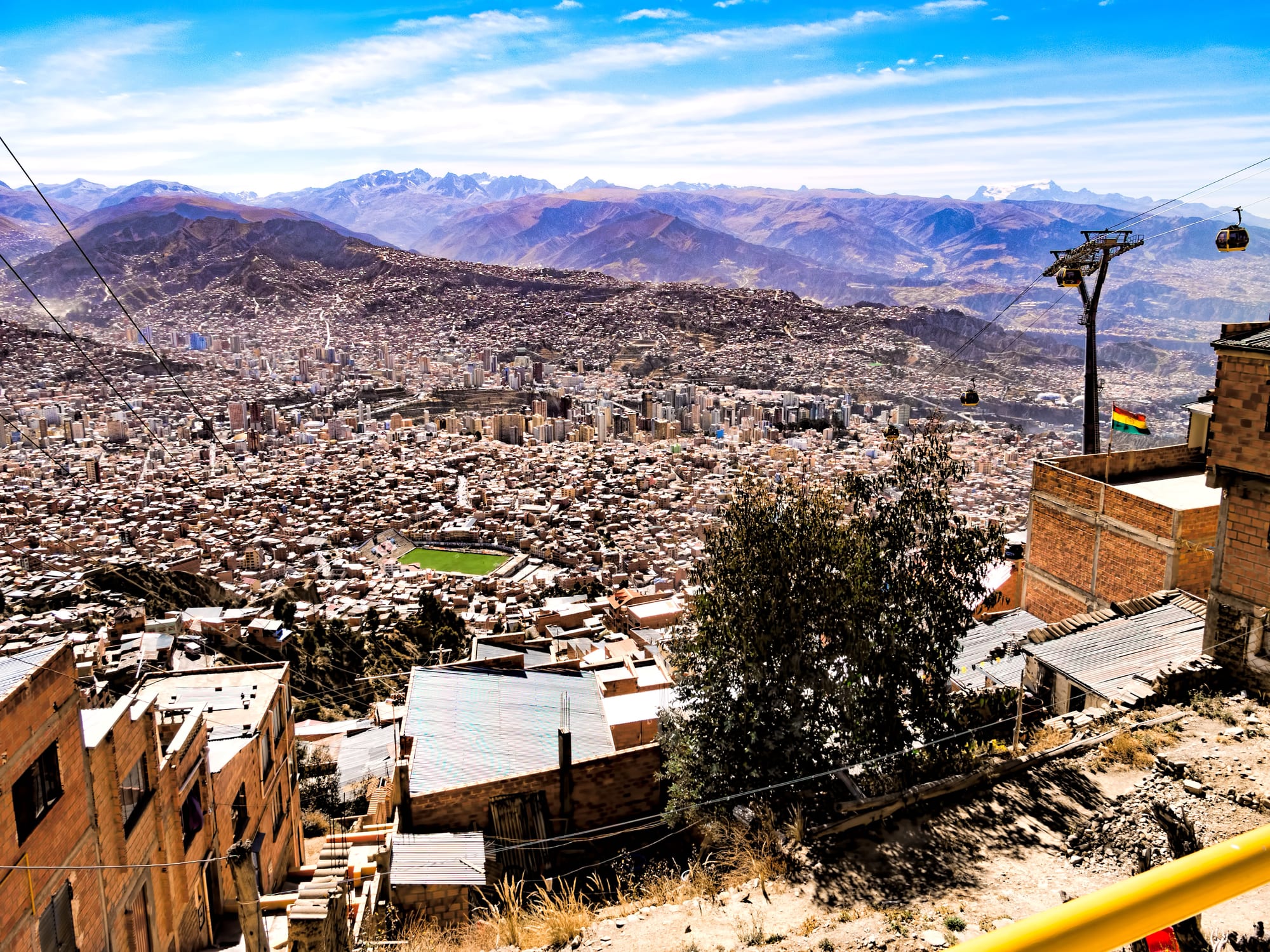
The brick houses and tower blocks of La Paz filling a wide canyon below brown mountains, with a cable car line on the right

La Paz, Uyuni & the Altiplano, Bolivia

La Paz

La Paz seen from just below the canyon rim at El Alto, beside a line of the Mi Teleférico cable cars. (Dan Lundberg / Wikimedia Commons · CC BY-SA 2.0)

Bolivia's seat of government, founded by the Spanish in 1548 and set in the steep canyon of the Choqueyapu River at about 3,650 metres, below the plateau city of El Alto and the snows of Illimani. Colonial churches, Aymara markets and the government buildings of Plaza Murillo fill the centre, and a network of cable cars now links the canyon with the rim.

Neighbourhoods

  • The centre and Casco Viejo
    • First-time visitors
    • Historic district
    • Museums

    The old colonial core off the Prado, the tree-lined main avenue, around Plaza Murillo with its cathedral, government buildings and Congress. Steep streets lead to Calle Jaén, the street with the most museums in the city, and government offices and banks make it busy on weekdays.

    Open in Maps
  • San Francisco, Sagarnaga and the Witches' Market
    • Markets
    • Close to public transport
    • Budget stays

    The streets climbing from the church of San Francisco — Sagarnaga, Linares and Illampu — are the traditional base for backpackers, packed with craft shops, tour agencies, hostels and cafés. The stalls of the Witches' Market line Calle Linares, and the Lanza market is close by.

    Open in Maps
  • Sopocachi
    • Nightlife
    • Best for food
    • Quiet and residential

    A large residential district south of the centre with a bohemian reputation, built up in the republican era around Plaza Abaroa and Plaza España. Bars, restaurants and cafés gather here, and the Montículo park on its hill gives views towards Illimani.

    Open in Maps
  • Miraflores
    • Sport
    • Quiet and residential

    A fully built-up residential district east of the centre, redeveloped from the 1950s, with wide avenues, the Hernando Siles football stadium and a botanical garden.

    Open in Maps
  • Zona Sur and Calacoto
    • Upmarket dining
    • Quiet and residential

    The lower, warmer southern end of the canyon, a large residential area. Calacoto, one of the city's biggest residential districts, has restaurants, bars and clubs, and the Valle de la Luna is nearby.

    Open in Maps
  • El Alto
    • Markets
    • Local life
    • Views

    The separate, fast-growing city on the plateau rim about 400 metres above the canyon, largely Aymara, where the airport, the long-distance roads and the huge Thursday and Sunday market are found. Most visitors come up by cable car for the views, the market or the Sunday wrestling rather than to stay.

    Open in Maps

Things to do

Famous landmarks

  • Plaza Murillolandmark

    The central square of the old town and the open space most bound up with Bolivia's political life, framed by the cathedral, the legislative palace and the old presidential palace.

    Open in Maps
  • Palacio Quemadolandmark

    The 'Burnt Palace' on Plaza Murillo, named after a fire during an uprising in 1875 and the presidential residence from 1853 to 2018, when the 30-storey Casa Grande del Pueblo replaced it.

    Open in Maps
  • La Paz Cathedrallandmark

    A neoclassical cathedral on Plaza Murillo begun in 1835 and inaugurated in 1925, whose side towers opened in 1989; it holds the remains of Marshal Andrés de Santa Cruz.

    Open in Maps
  • Basilica of San Franciscolandmark

    The city's best-known colonial church, built between 1743 and 1772 on the square that bears its name, with a carved façade completed in 1790.

    Open in Maps

Museums and old streets

  • National Museum of Artmuseum

    Bolivia's national art collection in the Palacio Diez de Medina, a colonial mansion near Plaza Murillo, strong on colonial painting by Melchor Pérez de Holguín and Gregorio Gamarra.

    Open in Maps
  • Calle Jaénneighborhood

    A colonial street in the historic centre with more museums than any other in the city, including one of musical instruments, and an art gallery.

    Open in Maps
  • The Witches' Marketmarket

    Stalls along Calle Linares, run largely by Aymara women, selling herbs, potions, amulets and the dried llama foetuses offered to Pachamama under the foundations of new houses; named intangible cultural heritage of La Paz in 2019.

    Open in Maps
  • Coca Museummuseum

    A small museum on Calle Linares explaining the coca leaf's place in Andean life and its history from ritual and medicine to cocaine.

    Open in Maps

Cable cars and viewpoints

  • Mi Teleféricotransit hub

    The urban cable-car network opened in 2014, ten colour-coded lines as of October 2019 and the longest such system in the world; the Red and Yellow lines climb to El Alto with views over the whole canyon.

    Open in Maps
  • Mirador Killi Killiviewpoint

    A lookout above the centre, facing towards Illimani over the city.

    Open in Maps
  • Valle de la Lunapark

    About 10 kilometres south of downtown, a small protected area of eroded clay and sandstone spires in shades of beige, red and violet.

    Open in Maps
  • Muela del Diablotrail

    The 'Devil's Molar', the jagged volcanic neck of an extinct volcano south-east of downtown, popular for hiking and mountain biking.

    Open in Maps

Markets, sport and El Alto

  • Feria 16 de Juliomarket

    El Alto's Thursday and Sunday market, a huge open-air market spreading for blocks with everything from car parts and clothes to food; the Red Line cable car ends nearby.

    Open in Maps
  • Cholita wrestlingattraction

    Sunday shows in El Alto in which Aymara women wrestlers fight in braids, bowler hats and layered pollera skirts — part of a wider movement of Aymara women pushing back against negative stereotypes.

    Open in Maps
  • Hernando Siles Stadiumattraction

    Bolivia's largest stadium, with about 41,000 seats at 3,582 metres in Miraflores, home to the rival clubs Bolívar and The Strongest and to a national team that visiting sides dread at altitude.

    Open in Maps

Short trips from the city

  • Tiwanakuattraction

    A pre-Columbian archaeological site near Lake Titicaca, one of the largest in South America and a UNESCO World Heritage Site, with the Akapana pyramid, the Kalasasaya enclosure and the Gate of the Sun.

    Open in Maps
  • Yungas Roadtrail

    The 64-kilometre 'Death Road' dropping from the high passes towards the subtropical Yungas, long considered the most dangerous road in the world; since a paved road replaced it for most traffic it has been ridden by mountain-bikers, and cyclists have died on it.

    Open in Maps
  • Chacaltayaviewpoint

    A 5,395-metre peak in the Cordillera Real whose glacier, once used for skiing, had disappeared completely by 2009; the drive up gives wide views over the range and the Altiplano.

    Open in Maps
  • Huayna Potosítrail

    A 6,088-metre peak about 25 kilometres north of the city, the most popular high climb in Bolivia, by a glacier route on its normal side.

    Open in Maps

Seasonal events

  • AlasitasFrom 24 January, for several weeks

    A fair honouring Ekeko, the Aymara god of abundance, at which people buy miniature houses, cars, banknotes and diplomas and have them blessed in the hope of receiving the real thing.

  • Gran PoderLate May or June

    The Señor del Gran Poder parade, on the UNESCO intangible heritage list, in which tens of thousands of dancers in Morenada and other troupes process through the city.

  • Todos Santos1–2 November

    All Saints, a public holiday in Bolivia, when families remember their dead with bread figures called tantawawas.

Eat and drink

Long-standing places and food districts in La Paz. Hours, ratings and directions come from your maps app, always current.

La Paz classics

  • Salteña stands and bakeriesrestaurant

    Salteñas — baked pasties of slightly sweet dough filled with meat, potato and broth — are a mid-morning snack across Bolivia, sold in squares and streets.

    Open in Maps
  • Sandwich de chola stallsrestaurant

    Street stands selling the sandwich de chola, a bread roll filled with pork, pickled vegetables, tomato and the herb quirquiña, a Bolivian speciality.

    Open in Maps

Food districts and markets

  • Mercado Lanzamarket

    A supply market in the historic centre near the church of San Francisco, descended from the colonial trading inns that stood around the church.

    Open in Maps
  • Feria 16 de Julio food stallsmarket

    Food stalls at El Alto's Thursday and Sunday fair feed traders and shoppers.

    Open in Maps

Cafés and bars

  • Sopocachi's bars and cafésneighborhood

    The city's main area for an evening out, with cafés, pubs and restaurants around Plaza Abaroa and the streets nearby.

    Open in Maps
  • Restaurants of Calacotoneighborhood

    A residential district of the Zona Sur with restaurants, bars and clubs.

    Open in Maps

Experience La Paz

History

La Paz was founded on 20 October 1548 by the Spanish captain Alonso de Mendoza, at the Inca settlement of Laja on the Altiplano, to mark the end of the civil wars among the conquistadors of Peru; its full name, Nuestra Señora de La Paz, means Our Lady of Peace. It was soon moved down into the sheltered valley of Chuquiago Marka, on the Choqueyapu River, where it became a connecting point on the trade routes from Potosí and Oruro to Lima. The colonial city grew around a grid of churches and squares.

In 1781 the Aymara leader Túpac Katari besieged the city for months before he was captured and executed, and in 1809 La Paz rose in one of the continent's first calls for self-government; its leader, Pedro Domingo Murillo, was hanged and is remembered in the name of the central square. After independence the city grew as a commercial centre, and in 1898 it became the de facto seat of government, while Sucre remained the constitutional capital.

The 20th century filled the canyon. Migrants from the countryside settled the plateau above, where El Alto became a separate city in 1985. The two cities were at the centre of the 2003 gas-war protests, and in 2014 the first lines of Mi Teleférico opened, linking canyon and rim by cable car. Today about 756,000 people live in the city, and some 2.2 million in the wider urban area.

Culture & Customs

Aymara culture runs deep in La Paz. The pollera skirt, shawl and bowler hat of the cholita are an everyday sight in its markets and offices. Andean ritual sits alongside Catholic practice: yatiri, traditional healers and diviners, work from the stalls of the Witches' Market, llama foetuses are buried under the foundations of new houses as offerings to Pachamama, and at the Alasitas fair in January people buy miniature houses, cars and banknotes to be blessed for the year ahead under the eye of Ekeko, the god of abundance.

Festivals are dance events on a huge scale. The Gran Poder parade, on the UNESCO intangible heritage list, sends tens of thousands of dancers in heavy embroidered costumes through the streets, with the Morenada's rattling and the brass bands carrying through the canyon. Folk music — panpipes, quena flutes and the charango — is played in peñas, small music restaurants, and the city has a strong painting tradition from the colonial masters in the national art museum to modern artists of Andean themes.

Football matters intensely: the rivalry between Bolívar and The Strongest, both based at the Hernando Siles stadium, divides families, and the altitude gives the national team a feared home ground. Paceños are reserved but courteous with strangers, value a proper greeting, and are proud of a city that holds the country's government and much of its political life.

Daily Life

About 756,000 people lived in La Paz at the 2024 census, making it Bolivia's third-largest city, and the metropolitan area that includes El Alto and smaller towns has about 2.2 million. Altitude orders the social map: the more affluent districts lie lower in the canyon, Sopocachi and the high-rises near the centre house much of the middle class, and El Alto on the rim above has grown fast with migrants from the countryside.

The city lives on government, services and trade. Ministries, the legislature and the presidency employ thousands, while a vast informal economy of market stalls, street vendors and family businesses keeps the centre crowded from early morning; the Cervecería Boliviana Nacional, founded by German immigrants, is among the city's biggest companies. Days start early and cold, with api and pastries at street stalls, while cable cars and minibuses fill with commuters from El Alto.

Protest is part of the city's rhythm, because the seat of government is where marches converge. The end of fuel subsidies and the economic slump fed mass protests and road blockades that paralysed much of the country for more than 50 days in May and June 2026, and protests and roadblocks have continued to flare since.

Food

Paceño cooking is highland food, built on potatoes, corn, broad beans and cheese. The plato paceño brings together corn on the cob, broad beans, potato and a slab of fried cheese; fricasé paceño is a spicy pork and hominy stew; and chairo is a thick soup of chuño — potatoes freeze-dried in the winter frosts — with meat and vegetables. Lunch is the main meal, often an almuerzo, a set menu of soup and a main course served in small restaurants and market stalls across the city.

Street food fills the gaps. Salteñas, baked pasties of slightly sweet dough filled with meat, potato and broth, are the mid-morning snack; the sandwich de chola, a roll filled with pork, pickled vegetables, tomato and quirquiña, is a Bolivian speciality; and anticuchos, skewers of beef heart, are another street favourite. Trout and the tiny fried fish called ispi come up from Lake Titicaca.

On cold mornings people drink api, a hot, sweet drink of morocho corn with cinnamon and milk, often with a fried sweet fritter called a buñuelo. Coca tea is offered everywhere to ease the altitude. Paceña, named after the city, is the leading beer, and singani, a white-grape brandy from the southern valleys, is the base of the chuflay.

Planning tools

Budget

La Paz is inexpensive by South American standards: set lunches, market meals, minibuses and cable cars cost little, and hostels cluster around Sagarnaga. The bigger costs are guided trips — Tiwanaku, the Yungas Road by bike, climbs in the Cordillera Real — and the better hotels and restaurants of the Zona Sur. The national dollar shortage makes prices less predictable than they were.

Daily Budget Midrange
USD 60–120 (hotel in the centre or Sopocachi, restaurant meals, guided day trips, taxis)
Daily Budget Shoestring
USD 25–45 (hostel bed, set-menu lunches and market food, minibuses and cable cars)

Carry clean US dollar notes and small boliviano notes; much of the best of the city — the markets, the plazas and the cable-car views — costs little or nothing.

Best Time to Visit

May to October is the dry season, with clear blue skies, views of Illimani and good conditions for trips to the mountains, though nights are cold and June to August is busiest. The wet season, roughly November to March, brings afternoon storms and some road closures, but also Alasitas in late January.

Suggested Number of Days

Two or three days covers the city itself and also allows time to adjust to the altitude before going higher. Allow four to six days to add day trips into the surrounding mountains and the Altiplano. Blockades or altitude sickness can add a day.

First Visit
2–3 days
With Surroundings
4–6 days

Transportation

The Mi Teleférico cable cars are the easiest way around: ten lines (as of October 2019) link the centre, Sopocachi, Miraflores, the Zona Sur and El Alto, with views on every ride. Minibuses and micros run everywhere, cheaply and slowly, their routes shown on boards in the windscreen. Radio taxis and app taxis fill the gaps. Traffic in the narrow canyon is heavy, especially at rush hours.

Use radio or app taxis rather than unmarked cars, and allow extra time for every journey on days of marches or blockades.

Airport & Station Connections

El Alto International Airport, the highest international airport in the world at about 4,060 metres, is on the plateau about 13 kilometres west of the city; radio taxis and shared taxis run down to the centre. Long-distance buses arrive at the main bus terminal near the centre, and buses from the Lake Titicaca shore and Tiwanaku use terminals near the cemetery.

Walkability

The centre is compact enough to walk, but almost every street is steep and the altitude makes even short climbs tiring for the first days. The Prado is the flattest route through downtown. Pavements are crowded with street vendors, and traffic is fast at junctions. Sopocachi is pleasant on foot; the Zona Sur and El Alto are reached by cable car or taxi.

Safety

Violent crime against tourists is relatively low, but manage the risks: fake-taxi and fake-police scams and express robberies occur in La Paz, Cochabamba, and on the Uyuni and Copacabana routes, and petty theft is common on overnight buses and in markets. Altitude is the main health hazard: headaches, breathlessness and poor sleep are normal at first, and serious altitude sickness is possible. El Alto is the frequent scene of roadblocks that can cut the city off, and the Yungas road has seen fatal falls.

Rest on arrival, drink water, use app or radio taxis at night, never show money to anyone claiming to be police, and follow local news for marches and blockades. Check current official travel advice before travelling.

Climate

A subtropical highland climate shaped by altitude: the sun is fierce, the air thin and dry, and the difference between day and night large. The sheltered canyon is milder than the open plateau of El Alto, and the lower Zona Sur is warmer still.

Summer
wet season, December to February at its peak (November to March overall): mild to warm days and frequent rain; in spring, highs average about 22°C and lows about 5°C
Winter
dry season, May to October: clear skies, mild days and cold to very cold nights; on the El Alto plateau above, nights often approach or fall below 0°C

Local Customs

Aymara culture is everywhere, from the cholitas' bowler hats and pollera skirts to offerings to Pachamama buried under the foundations of new houses. Greetings matter: a 'buenos días' before any question goes a long way. Coca tea is offered to newcomers for the altitude, and chewing coca leaves is legal and normal. Small tips are welcome in restaurants.

Ask before photographing people, especially cholitas, market vendors and the yatiri of the Witches' Market, and dress modestly in churches. Coca leaves and coca tea are illegal to carry into many other countries.

Common Payment Methods

The currency is the boliviano (Bs). A shortage of US dollars since about 2023, and the end of the boliviano's peg to the dollar in June 2026, have made exchange rates and card payments unpredictable. Bring US dollars in good condition, change only what is needed, and keep small notes for markets, minibuses and entrance fees; do not rely on ATMs or cards.