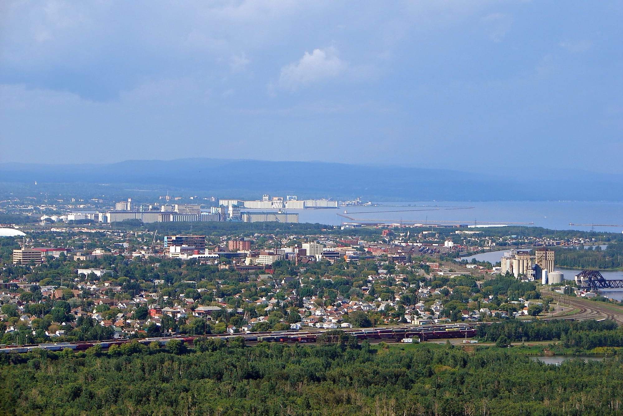
Thunder Bay's low-rise city, grain elevators and harbour on Lake Superior, with the long ridge of the Sleeping Giant beyond

Ontario, Canada

Thunder Bay

Thunder Bay and its harbour on Lake Superior, seen from Mount McKay. (P199 / Wikimedia Commons · CC BY-SA 3.0)

The largest city of north-western Ontario, at the head of Lake Superior facing the Sleeping Giant. Formed in 1970 from the rival twin ports of Fort William and Port Arthur, it grew on the fur trade, railways and the grain trade from the Prairies, and is now a regional centre of health care, education and government with a strong Finnish and Indigenous heritage.

Neighbourhoods

  • Port Arthur and the north core
    • First-time visitors
    • Waterfront
    • Nightlife

    The northern of the two old cities, on rocky Canadian Shield hills facing the Sleeping Giant. Its downtown runs down to Marina Park and the Prince Arthur's Landing waterfront, and the city has been developing it as an entertainment district of restaurants, pubs and events.

    Open in Maps
  • Bay and Algoma
    • Best for food
    • Historic district
    • Cafés

    The old Finnish quarter just west of downtown Port Arthur, around Bay Street and Algoma Street, where the Finnish Labour Temple stood. Cafés, bakeries, shops and restaurants line the streets, and the neighbourhood remains the centre of the city's Finnish heritage.

    Open in Maps
  • Fort William and the south core
    • Local life
    • History

    The southern of the twin cities, on flat land along the Kaministiquia River where the fur trade posts and the railway yards stood. Its old downtown has declined since amalgamation, but it holds civic buildings, older neighbourhoods and the river islands.

    Open in Maps
  • Intercity
    • Shopping
    • Close to the highways

    The once-empty land between the two old cities, along the Neebing and McIntyre rivers, where business, shopping centres and government offices moved after 1970. It is the practical, car-centred heart of the modern city.

    Open in Maps
  • Current River
    • Quiet and residential
    • Parks

    A residential area at the far north-east of the city, annexed to Port Arthur in 1892, beside the wooded Current River and Centennial Park and close to the highway east towards the Terry Fox monument.

    Open in Maps

Things to do

History and landmarks

  • Fort William Historical Parkmuseum

    A reconstruction of the North West Company's Fort William fur trade post as it stood in 1815, on the Kaministiquia River at Point de Meuron, opened in 1973 with costumed interpreters.

    Open in Maps
  • Terry Fox Memorial and Lookoutviewpoint

    A monument depicting Terry Fox beside the Trans-Canada Highway on the city's outskirts, near where his Marathon of Hope run across Canada for cancer research ended, with a panoramic view of the city and its surroundings.

    Open in Maps
  • Thunder Bay Art Gallerymuseum

    Northern Ontario's largest gallery of contemporary Indigenous art, opened in 1976, with works by Norval Morrisseau, Daphne Odjig and Carl Beam; a new waterfront building is due to open in 2027.

    Open in Maps
  • Thunder Bay Museummuseum

    The city's history museum, run by a historical society with roots in 1908, with local and travelling exhibitions and large archives of photographs, maps and documents.

    Open in Maps

Parks and the waterfront

  • Marina Parkpark

    The waterfront park and marina at Prince Arthur's Landing, with a boardwalk, walking paths and a mariners' monument, the stage for Canada Day and summer festivals and the classic view of the Sleeping Giant.

    Open in Maps
  • Hillcrest Parkviewpoint

    A hilltop park in the north end with one of the few high views over the city, the harbour and the Sleeping Giant, a Second World War memorial and a plaque for a Paleo-Indian archaeological site more than 9,000 years old.

    Open in Maps
  • Centennial Parkpark

    A large park along the rocky Current River, created in 1967, with replicas of early 20th-century logging camps and a small train ride, the Muskeg Express.

    Open in Maps
  • Mount McKayviewpoint

    Anemki Wajiw, the highest of the Nor'Wester Mountains, on the Fort William First Nation reserve south of the city; a road has climbed to a plateau with views over Thunder Bay since 1933.

    Open in Maps

Arts and nights out

  • Magnus Theatreattraction

    The city's largest professional theatre, founded in 1971, staging six plays a season in a converted school on Red River Road.

    Open in Maps
  • Thunder Bay Community Auditoriumattraction

    The 1,500-seat hall that is the city's main venue for concerts and touring shows.

    Open in Maps

Short trips from the city

  • Kakabeka Fallspark

    The 'Niagara of the North', where the Kaministiquia River drops 40 m into a gorge about 30 km west of the city; the fragile shale gorge below is closed to visitors.

    Open in Maps
  • Sleeping Giant Provincial Parkpark

    A park of cliffs, mesas and forest on the Sibley Peninsula, whose rock formations form the reclining giant seen from the city, with hiking trails and a cross-country ski race each March.

    Open in Maps
  • Ouimet Canyonviewpoint

    A gorge 100 m deep and 2 km long, viewed from boardwalks and platforms, whose cold floor shelters arctic plants normally found far to the north.

    Open in Maps

Seasonal events

  • Sleeping Giant LoppetMarch

    A long-running cross-country ski race and city tradition on the trails of Sleeping Giant Provincial Park.

  • Canada Day at Marina Park1 July

    The city's national day celebrations on the waterfront, one of several summer events held in the park.

  • Festival of Indiasummer

    A festival of colours and Indian culture held at Marina Park.

  • Vox Popular Media Arts Festivalearly October

    An independent film festival, founded in 2005, showing local, Canadian and international films under the theme 'Films for the People'.

Eat and drink

Long-standing places and food districts in Thunder Bay. Hours, ratings and directions come from your maps app, always current.

Thunder Bay classics

  • The Persian Manrestaurant

    The restaurant best known for the Persian, the city's own sweet roll with pink icing, which locals eat plain or split, buttered and grilled.

    Open in Maps

Food districts and cafés

  • Bay and Algomaneighborhood

    The old Finnish quarter's streets of cafés, bakeries and restaurants, including the independent Calico Coffeehouse on Bay Street.

    Open in Maps
  • Sleeping Giant Brewing Co. Taproomrestaurant

    The taproom of a local brewery named after the city's landmark.

    Open in Maps

Experience Thunder Bay

History

Anishinaabe peoples, among them the Ojibwe, have long lived at the head of Lake Superior. French fur traders built posts on the Kaministiquia River in 1683 and 1717, both later abandoned, and in 1803 the Montreal-based North West Company made Fort William its mid-continent depot for the fur trade. In 1849 Jesuits founded a mission on the river, and under the Robinson Treaty of 1850 a reserve was set aside for the Ojibwe south of the river. A few miles north, a construction depot for the road to the Red River Colony was named Prince Arthur's Landing in 1870 and renamed Port Arthur by the Canadian Pacific Railway in 1883.

The railway set off a long rivalry. After a tax dispute and Port Arthur's seizure of a locomotive in 1889, the CPR moved its staff and facilities to Fort William, which boomed while Port Arthur slumped after its silver mines failed. The Prairie wheat boom then lifted both towns: rail lines and grain elevators multiplied, Port Arthur built Canada's first municipally owned electric street railway in 1892, and the twin cities claim the world's first use of daylight saving time, in 1908. Pulp and paper mills followed from 1917, and the Canadian Car and Foundry plant built Hawker Hurricane fighters during the Second World War.

On 1 January 1970 the two cities merged; a referendum chose the name Thunder Bay by a narrow plurality over "Lakehead". Since then trucking, the shift of grain exports to Pacific ports and the decline of forestry have closed elevators and mills, and the city has rebuilt itself as a centre of health care, education and government.

Culture & Customs

Thunder Bay's identity comes from its isolation and its mix of peoples. Finnish immigrants made it the home of the largest concentration of people of Finnish origin in Canada, and halls such as the Finnish Labour Temple, Scandinavia House, the Italian Cultural Centre and the Polish Legion reflect the immigrant communities that worked the railways, docks and mills. Saunas are common. The city also has a large Indigenous population, and the Thunder Bay Art Gallery is Northern Ontario's largest gallery specialising in contemporary Indigenous art.

The city was named a Cultural Capital of Canada in 2003. The Thunder Bay Symphony Orchestra, founded in 1960, is the only professional orchestra between Winnipeg and Toronto, Magnus Theatre has staged plays since 1971, and film festivals run through the year. Local customs include the shag, a combined shower and stag party held to celebrate an engagement, which originated here, and the Sleeping Giant appears on the coat of arms and the city flag, while the city logo is Animikii, the thunderbird.

Outdoor life is central. The Canadian Shield and the lake put hiking, skiing and paddling on the doorstep, and the city has hosted the 1981 Canada Summer Games, the 1995 Nordic World Ski Championships, the Scotties Tournament of Hearts in 2022 and the Women's Baseball World Cup in 2024. It also runs six indoor ice rinks and dozens of outdoor ones each winter.

Daily Life

The 2021 census counted 108,843 people in the city and 123,258 in the census metropolitan area, which includes surrounding townships and the Fort William First Nation. Indigenous people made up 14.1 per cent of the city's population at the census, a figure thought to be a substantial undercount. The city keeps two distinct civic identities, Port Arthur in the north and Fort William in the south, separated by the Intercity area where much business has moved.

As the largest city in north-western Ontario, Thunder Bay is the region's commercial, administrative and medical centre. Its biggest employers are public: the city, the regional hospital, the school board and the provincial government. Lakehead University, Confederation College and the western campus of the Northern Ontario School of Medicine, along with a law school, anchor its knowledge economy; a paper company is the largest private employer, and an Alstom plant builds transit vehicles. Shipments through the port have stabilised, and it remains an important part of the St. Lawrence Seaway, though grain traffic is far below its heyday.

The city faces serious problems. It had the highest per-capita homicide rate of any Canadian city from 2012 to 2014 and from 2016 to 2019, and set a record of 15 homicides in 2022. Daily life is shaped by long, cold winters, long drives and a strong attachment to the lake and the bush beyond the city limits.

Food

Thunder Bay's best-known food is the Persian, a deep-fried sweet roll shaped like a cinnamon bun and topped with a pink icing, especially popular here and unrelated to Persia despite its name. Locals eat it as it comes or split, buttered and grilled, and the Persian Man, with two locations, is the name most associated with it.

Finnish cooking has left a deep mark. The Hoito, a co-operative restaurant opened in 1918 in the basement of the Finnish Labour Temple on Bay Street, was famous for its Finnish pancakes and ran for more than a century until it closed during the pandemic in March 2020; the building was badly damaged by fire in December 2021, and the hall is being rebuilt. The Bay and Algoma neighbourhood around it still has bakeries, cafés such as the Calico Coffeehouse, and restaurants.

The lake and the forest supply the rest. Lake Superior and the inland lakes provide fish such as pickerel and whitefish, and Anishinaabe communities in the north-west harvest manoomin, wild rice, by canoe. Local breweries, among them one named after the Sleeping Giant, serve beer in taprooms around the city, and diners and pubs cater to a population that eats heartily through long winters.

Planning tools

Budget

Thunder Bay is moderately priced by Ontario standards, cheaper than Toronto for rooms and meals. The main costs are getting there — flights or a very long drive — and a hire car, since the best sights lie outside the city. Ontario's 13 per cent harmonised sales tax is added at the till.

Daily Budget Midrange
USD 170–300 (mid-range hotel, restaurant dinners, Fort William entry, a hire car)
Daily Budget Shoestring
USD 80–125 (hostel or budget motel, bakeries and diners, city buses, park day passes)

A hire car is the single best investment here: Kakabeka Falls, the Sleeping Giant and Ouimet Canyon are all outside the bus network.

Best Time to Visit

June to September for hiking on the Sleeping Giant, the waterfront and Fort William Historical Park; late September brings autumn colour. Winter is long and very cold but sunny, and good for cross-country skiing, with the Sleeping Giant Loppet in March.

Suggested Number of Days

Two or three days are enough for the city. Four or five allow time for the parks and the Lake Superior shore around it. Distances outside the city are long, so a visit without a car takes more time.

First Visit
2–3 days
With Surroundings
4–5 days

Transportation

The city sprawls over more than 320 square kilometres between its two old downtowns, and a car is the easiest way around. Thunder Bay Transit runs about 20 bus routes across the urban area, with limited service to Neebing and the Fort William First Nation. Highway 11/17 and Highway 61 meet in the Thunder Bay Expressway.

Outside the city, fuel up before long drives: towns along the Trans-Canada Highway are far apart.

Airport & Station Connections

Thunder Bay Airport, within the city, is one of the busiest in Ontario by aircraft movements and the usual way in. Ontario Northland coaches run to Winnipeg and Sault Ste. Marie. By road, the city sits on the Trans-Canada Highway, a long drive from southern Ontario. Passenger trains stopped serving Thunder Bay in 1990.

Walkability

Each of the two old downtowns can be explored on foot, and the waterfront at Marina Park and the Bay and Algoma area are close to the Port Arthur core. The distances between districts are long, though, and Intercity is built around the car. Pavements are icy for much of the winter.

Safety

Ontario is safe for visitors, and Toronto has low crime for a city of its size, though pickpocketing and car theft occur. Thunder Bay, however, has had the highest per-capita homicide rate of any Canadian city in several recent years, reaching a record in 2022. Outdoors, the risks are extreme winter cold, black bears, cold Lake Superior water and long, empty highways.

Use taxis at night between districts, dress for severe cold in winter, and carry water and warm layers on park trails. Check current official travel advice before travelling.

Climate

A warm-summer humid continental climate, with Lake Superior cooling the summers and softening the winters near the shore. The city is sunny, with about 2,100 hours of sunshine a year, and winters are drier and less snowy than on the American side of the lake, though much colder.

Summer
mild to warm — July averages 18.0°C, with daily highs around 25°C
Winter
very cold and dry — January averages −13.4°C, with daily highs around −7.6°C

Local Customs

Tipping of 15–20 per cent is expected in restaurants and taxis, and sales tax is added at the till. Dress is casual and practical. Finnish traditions remain strong, and saunas are common. The city's large Indigenous population and the First Nations of the region are part of daily life.

Ask before photographing people at Indigenous ceremonies, and follow any instructions from organisers.

Common Payment Methods

The currency is the Canadian dollar. Cards and contactless payment are accepted almost everywhere, and cash is rarely necessary; cash totals are rounded to the nearest five cents. ATMs are widely available in both old downtowns and Intercity.