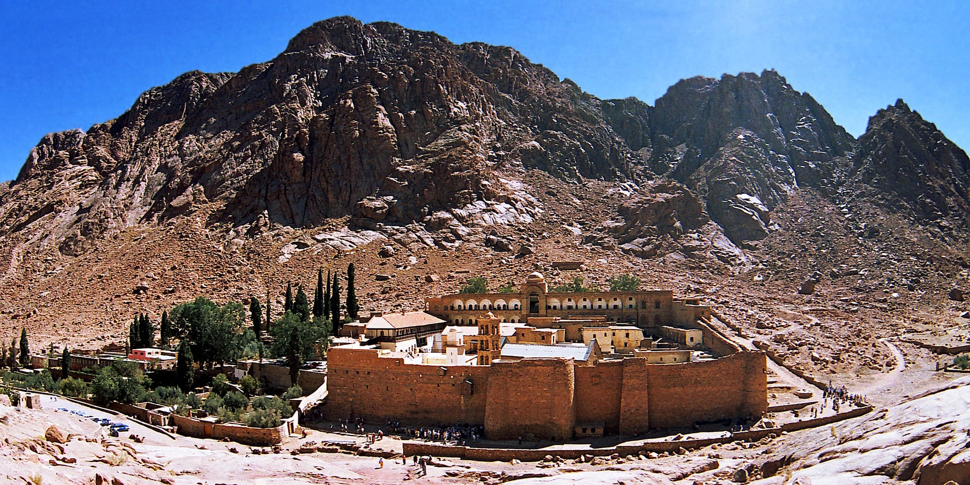
A walled monastery of stone buildings and cypress trees in a bare rocky valley beneath steep dark mountains

The Red Sea & Sinai, Egypt

Saint Catherine

Saint Catherine's Monastery in its valley beneath the peaks of South Sinai. (Dr. Ondřej Havelka (cestovatel) / Wikimedia Commons · CC BY 4.0)

A small town high in the granite mountains of South Sinai, built around the valley of Saint Catherine's Monastery and the paths up Mount Sinai. It sits at about 1,600 m, among Jebeliya Bedouin gardens and bare peaks, and lives on pilgrimage, trekking and the flow of visitors who arrive at night to climb for the sunrise.

Neighbourhoods

  • Al-Milga
    • First-time visitors
    • Local life
    • Markets

    The town centre a few kilometres from the monastery, with the bus stop, bakery, grocers, a small mosque, guesthouses and the cheapest food. Everything practical in the area is here, and it is where most Bedouin families and seasonal workers live.

    Open in Maps
  • The monastery valley
    • Historic district
    • Walks
    • Pilgrimage

    Wadi el-Deir, the narrow valley holding the monastery, its gardens and olive trees, a few hotels and the car park where night climbers gather. The two routes up Mount Sinai begin here, and the valley is quiet and very dark once the buses leave.

    Open in Maps
  • The Bedouin gardens and mountain camps
    • Trekking
    • Quiet and residential
    • Nature

    Walled orchards of apple, apricot, almond and olive, watered by wells and terraces, scattered through the high wadis around the town, with simple Jebeliya camps used by trekkers. Reached on foot or by pick-up along rough tracks.

    Open in Maps

Things to do

The monastery and the mountains

  • Saint Catherine's Monasterylandmark

    A fortified Greek Orthodox monastery built between 548 and 565 under Justinian and inhabited ever since, with a Byzantine basilica, a Fatimid mosque of 1106, celebrated icons and the world's oldest continuously operating library; part of the Saint Catherine Area, a UNESCO World Heritage Site since 2002.

    Open in Maps
  • Mount Sinaitrail

    The 2,285 m peak traditionally identified with the giving of the Ten Commandments, climbed from the monastery either by the long camel path or by the steep Steps of Repentance, usually at night to reach the summit for sunrise.

    Open in Maps
  • Mount Catherinetrail

    At 2,629 m the highest mountain in Egypt, a longer and harder climb south of the monastery, with a chapel built in 1905 and a meteorological station at the summit.

    Open in Maps
  • Saint Catherine Protectoratepark

    The protected area covering the high mountains around the town, created to safeguard their rare plants, wildlife and Bedouin cultural landscape.

    Open in Maps

Short trips

  • Feiranattraction

    A palm oasis about 40 km west, in the largest and widest wadi of southern Sinai, with a small monastic community and ruins from the early Christian centuries.

    Open in Maps
  • Serabit el-Khadimlandmark

    A pharaonic temple to Hathor above the turquoise mines of western Sinai, where some of the earliest alphabetic inscriptions were found.

    Open in Maps
  • Dahabneighborhood

    A relaxed coastal town on the Gulf of Aqaba, the usual base for visitors combining the mountains with reef diving and snorkelling.

    Open in Maps
  • Coloured Canyontrail

    A narrow sandstone gorge banded in red, yellow and purple, walked on desert trips from the Sinai coast.

    Open in Maps

Eat and drink

Long-standing places and food districts in Saint Catherine. Hours, ratings and directions come from your maps app, always current.

Saint Catherine classics

  • Al-Milga restaurantsneighborhood

    Plain, cheap Egyptian cooking for residents, drivers and trekkers: grilled chicken, rice, lentils, ful, ta'meya and salads, served in a handful of simple places around the town centre.

    Open in Maps
  • Bedouin camp cookingneighborhood

    On mountain treks, Jebeliya hosts bake bread on a domed metal sheet or in embers and cook goat or chicken slowly over coals, with rice and vegetables.

    Open in Maps

Shops and cafés

  • Al-Milga bakery and grocersmarket

    The town's bread oven, small supermarkets and fruit stalls, which also supply climbers with water, dates and biscuits before the night ascent.

    Open in Maps
  • Mountain tea housescafe

    Bedouin-run stalls along the camel path and near the summit sell sweet tea, coffee and blankets to climbers through the cold hours before dawn.

    Open in Maps

Experience Saint Catherine

History

The valley's history begins with hermits. From the third century Christian ascetics settled in the Sinai mountains, drawn by the peak above, identified with the mountain where Moses received the law, and by a bush venerated as the Burning Bush of Exodus. A chapel was built here in the fourth century under the empress Helena, and in the sixth the emperor Justinian enclosed the site with the high granite walls that still stand.

The monastery survived every change of power in the region. It came to hold the relics of Saint Catherine of Alexandria, which gave it its present name and drew Latin and Orthodox pilgrims alike, and it kept its independence under Muslim rule, tradition holding that Muhammad himself granted it protection. A mosque stands inside the walls. Its isolation preserved an extraordinary library and collection of icons, including works that escaped the Byzantine destruction of images; among its manuscripts was the fourth-century Codex Sinaiticus, removed in the nineteenth century.

The town outside grew much later. Through the twentieth century it was a scattering of Jebeliya Bedouin gardens and houses; the Israeli occupation of Sinai from 1967 until the withdrawal completed in 1982 brought the first roads and visitors, and after Egypt's return the road from Sharm El Sheikh, the settlement at Al-Milga and a tourism economy took shape. The mountains were made a protected area in 1988 and the monastery and its surroundings inscribed as a UNESCO World Heritage Site in 2002. In May 2025 an Egyptian appeal court ruled on the ownership of the land beneath the monastery, a case connected with the state's Great Transfiguration development project.

Culture & Customs

The town's population is overwhelmingly Jebeliya Bedouin, a tribe whose name comes from the Arabic for mountain and whose traditional role is bound up with the monastery: by long tradition their ancestors were settled here to serve it, and families have worked its gardens, guarded its gates and guided its visitors for centuries. They are Muslim, speak their own dialect of Arabic, and hold an unusually close relationship with a Christian community — an arrangement that has outlasted every ruler of Sinai.

Their mountain culture is distinct from that of the Bedouin on the coast. Families keep walled orchard gardens in the high wadis, with apples, apricots, almonds, figs and olives grown behind stone walls and watered from wells, and move between the town and these gardens through the year. Knowledge of the paths, of water sources and of medicinal plants underpins the trekking economy, and guiding in the protected area is largely in local Bedouin hands, which gives the community a stake in it.

On the other side of the monastery walls is a Greek Orthodox community that has kept the liturgy going here for some fifteen centuries, with services at night and a calendar that visitors rarely see. Between the two, the town's manners are conservative and quiet: modest dress, no drinking, early nights, and a hospitality that begins with tea. The other rhythm is the arrival of buses before midnight and their departure a few hours after dawn.

Daily Life

Only a few thousand people live in Saint Catherine, most of them in Al-Milga, and the town is one of the highest and coldest in Egypt. Nearly everyone depends on visitors: guiding treks and camel trips, driving pick-ups, running camps and guesthouses, cooking, and selling water, bread and blankets to climbers. Orchard gardening, goat herding and remittances from relatives working on the coast fill the gaps, and a share of families still spend part of the year in the mountains rather than the town.

Life is shaped by altitude and isolation. Nights are cold for much of the year and heating is expensive; water comes from wells and tankers; supplies arrive by road from the coast, so prices are higher than at sea level; and medical care beyond a small clinic means a two-hour drive. Employment is seasonal and thin, and the town empties whenever tourism to Sinai falters, as it has repeatedly over the past two decades and again with the disruption to regional travel that followed the war beginning in February 2026.

The daily rhythm is unusual. Afternoons are quiet, the shops in Al-Milga stir in the evening, and the town's busiest hours are between midnight and sunrise, when guides, drivers and tea sellers work the mountain while everyone else sleeps. Conservation rules in the protected area, grazing and water rights, and how much of the tourist income reaches Bedouin families rather than coastal operators are the recurring local arguments.

Food

Food here is simple and shaped by what can be carried up from the coast or grown in the wadis. The Jebeliya bake bread on a domed metal sheet or bury the dough in hot sand and embers, and the standard meal at a camp is goat or chicken cooked slowly over coals with rice, lentils and whatever vegetables are to hand, eaten seated on rugs from shared dishes.

The gardens supply the town's own produce: apples, apricots, almonds, figs, pomegranates and olives, dried or preserved for the winter, and herbs gathered from the mountains — sage, wild mint and thyme — which flavour the tea. Tea is constant, brewed strong and very sweet over a fire, and is the first thing offered to a guest and the thing most climbers remember, bought from a stall on the path in the cold before dawn.

In Al-Milga the food is ordinary Egyptian and cheap: ful medames, slow-cooked fava beans eaten with bread at breakfast; ta'meya, the fava-bean falafel; koshari, the bowl of rice, macaroni, lentils, chickpeas, fried onions and spiced tomato sauce; grilled chicken, and rice with vegetables. Alcohol has no place in the town, and drinks are tea, coffee and juice.

Planning tools

Budget

This is a cheap place to stay by Egyptian standards, with simple guesthouses, Bedouin camps and a monastery hostel rather than resorts, and very little to spend money on. The real costs are transport into the mountains, the fees for the protected area and guided treks, and the Bedouin guide required for climbs beyond the main path.

Daily Budget Midrange
USD 95–230 (hotel in the valley, guided trekking with a Bedouin guide, private transport from the coast)
Daily Budget Shoestring
USD 25–45 (guesthouse or Bedouin camp, local restaurants, shared transport, the night climb with a group)

Bring enough cash for several days, since banking is minimal, and hire guides through the local Bedouin community, which depends on that work.

Best Time to Visit

March to May and September to November are the best months for walking, with warm days and cold nights. Summer days are hot but far cooler than the coast, and the nights are pleasant. Winter is cold, with freezing nights, ice on the paths and occasional snow on the peaks. The war that began in February 2026 has disrupted aviation and tourism across the region.

Suggested Number of Days

Many arrive overnight from the coast and leave within a day. Staying one or two nights makes the climb and the monastery far less rushed, and three or four allow longer treks in the high mountains with a Bedouin guide.

First Visit
1–2 days
With Surroundings
3–4 days

Transportation

Everything in the town is reached on foot or by pick-up taxi, and the monastery is a few kilometres from Al-Milga. Buses and minibuses connect with Sharm El Sheikh, Dahab, Nuweiba and Cairo, though services are few and most visitors come on an organised overnight trip from the coast. Mountain tracks beyond the town need a four-wheel drive or a guide.

Confirm the return journey before arriving, since departures are limited; carry a passport for the checkpoints on the mountain roads.

Airport & Station Connections

Most visitors come by road: about two and a half hours from Sharm El Sheikh, around two from Dahab, and seven to eight hours from Cairo. The approach climbs steadily into the mountains and passes military checkpoints. The nearest busy international airport is at Sharm El Sheikh, and aviation across the region has been disrupted by the war that began in February 2026, so flights are less predictable than before.

Walkability

The town and the monastery valley are walked easily, though the few kilometres between them are on an open mountain road with no pavement, and the altitude of about 1,600 m makes gradients feel steeper. Beyond that, walking means trekking: rough paths, loose rock, thin shade and long distances between water.

Safety

The town is quiet and the main risks are environmental rather than criminal. The night climb is cold, dark and uneven underfoot, with a steep, slippery final staircase, and altitude, dehydration and falls account for most incidents; summit temperatures can approach freezing even when the coast is warm. Flash floods occasionally sweep the wadis after rain. The mountain roads pass checkpoints, and North Sinai, far to the north, remains off-limits to visitors.

Stay out of North Sinai, use reputable dive and boat operators, never touch the coral or feed fish, and follow beach closures. Check current official travel advice before travelling.

Climate

A high desert climate, much cooler than anywhere else in Egypt because of the altitude, with very large differences between day and night and almost no rain, though winter storms and rare snowfalls do occur on the peaks.

Summer
warm rather than hot by day, roughly 28–33°C, with cool nights
Winter
cold, about 10–15°C by day and at or below freezing at night, with ice on the higher paths and occasional snow

Local Customs

This is a religious place for two communities and dress is conservative: shoulders and knees covered for both men and women, and no shorts or bare arms inside the monastery, where visiting hours are limited and parts of the complex are closed to the public. Photography is restricted in the church and around the monks. Alcohol is not part of local life here and is rarely available. During Ramadan residents fast by day.

Ask before photographing Bedouin people, especially women; take nothing from the protected area, and treat the gardens and wells around the town as private property.

Common Payment Methods

The currency is the Egyptian pound, and this is a cash economy. Card acceptance is very limited, ATMs are few and can be empty, and guides, camps, taxis and small shops all expect notes. Bring enough from Sharm El Sheikh or Dahab to cover the stay, in small denominations for tips.