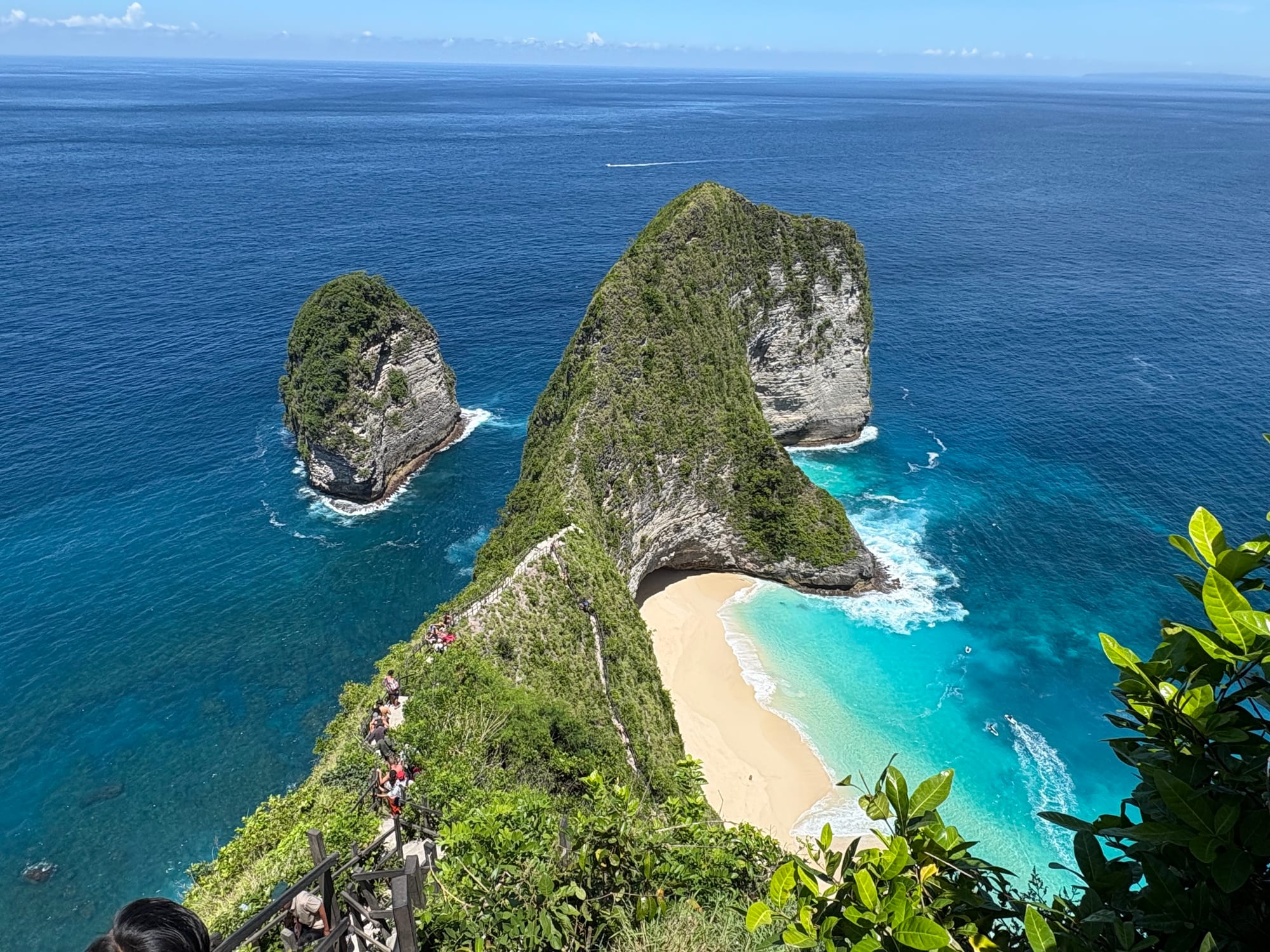
A green headland shaped like a crouching animal above a curving white beach and turquoise water, seen from a clifftop path

Bali, Lombok & Nusa Tenggara, Indonesia

Nusa Penida

Kelingking Beach on the south-west coast of Nusa Penida, seen from the clifftop viewpoint. (Chainwit. / Wikimedia Commons · CC BY 4.0)

The largest of the three Nusa islands, in the Badung Strait off south-east Bali, a dry limestone plateau ringed by white cliffs and small coves. Long a poor farming and seaweed-growing island, and long held in Balinese belief to be a place of dangerous unseen forces, it became a day-trip and diving destination once fast boats from Sanur cut the crossing to under an hour.

Neighbourhoods

  • Toyapakeh
    • Boat arrivals
    • Snorkelling
    • Close to the harbour

    The village and beach on the north-west corner, facing Nusa Ceningan across a narrow channel. Most fast boats from Sanur and from Lembongan land here or on the sand beside it, and the reef offshore is one of the island's main snorkelling grounds. It is small: a mosque, warungs, dive shops and a line of scooter and car hire stalls at the landing.

    Open in Maps
  • Sampalan and Batununggul
    • Local life
    • Markets
    • Services

    The administrative centre on the east coast, with the district offices, the main market, the harbour used by public boats from the Bali mainland, and most of the island's shops. Guesthouses here are cheaper and quieter than on the north-west coast, and the surroundings are working villages rather than resorts.

    Open in Maps
  • The north-west coast
    • Beaches
    • Diving
    • First-time visitors

    The strip running south from Toyapakeh past Crystal Bay, sheltered from the open ocean and holding most of the island's hotels, dive centres and beach warungs. The water is calm in the morning and the sunsets look back towards Bali and Mount Agung.

    Open in Maps
  • The southern plateau
    • Viewpoints
    • Quiet and residential
    • Scenery

    The interior and south coast, a dry upland of maize and cassava plots, dusty hamlets and temples that ends in cliffs several hundred metres high. The famous viewpoints are here, reached by steep, narrow roads; there are few places to stay and little shade.

    Open in Maps
  • Nusa Lembongan and Nusa Ceningan
    • Surfing
    • Nightlife
    • Beaches

    The two smaller islands off the north-west corner, joined to each other by a narrow suspension bridge, opened in 2017 and limited to pedestrians and two-wheelers, and reached from Penida in minutes. Lembongan has the bars, surf breaks and beach clubs; Ceningan is quieter, with a blue lagoon and seaweed plots between mangroves.

    Open in Maps

Things to do

Cliffs and viewpoints

  • Kelingking Beachviewpoint

    A limestone headland shaped like a dinosaur's head above a white cove, reached by a very steep and exposed stairway down the ridge.

    Open in Maps
  • Paluang Cliffviewpoint

    A clifftop above Kelingking with two small temples on the edge and a long view along the south-west coast.

    Open in Maps
  • Banah Cliffviewpoint

    A headland on the south coast with a natural rock arch standing offshore below sheer white walls.

    Open in Maps
  • Bukit Mundiviewpoint

    The highest point on the island, at 524 metres, with a hilltop shrine and views across the plateau to Bali on a clear day.

    Open in Maps

Beaches and coves

  • Crystal Baybeach

    A sheltered bay on the west coast with a small offshore island, used for swimming, sunsets and as the entry point for one of the best-known dive sites.

    Open in Maps
  • Atuh Beachbeach

    A cove on the east coast below a long stairway, enclosed by rock pinnacles and looked down on from the neighbouring Diamond Beach cliffs.

    Open in Maps
  • Diamond Beachbeach

    A white cove on the south-east corner reached by a staircase cut into the cliff, named for the tapering rock stacks on its sand.

    Open in Maps
  • Broken Beachviewpoint

    Pasih Uug, a circular cove on the south-west coast whose seaward wall has collapsed into a natural arch, with Angel's Billabong, a tidal rock pool, a short walk away.

    Open in Maps

Reefs and dive sites

  • Manta Pointattraction

    A cleaning station off the south-west coast where reef manta rays gather over shallow rock; conditions are often rough and swell can close it.

    Open in Maps
  • Toyapakeh reefattraction

    A drift dive and snorkelling site in the channel between Penida and Ceningan, with hard coral and strong, cold currents from the Indian Ocean.

    Open in Maps

Temples and villages

  • Goa Giri Putrilandmark

    A large limestone cave temple in the east of the island, entered through a narrow gap in the rock and opening into a chamber used for Hindu worship.

    Open in Maps

Short trips from the island

  • Nusa Lembonganattraction

    The smaller island across the Toyapakeh channel, with surf breaks, mangroves, seaweed plots and a bridge to Nusa Ceningan.

    Open in Maps

Seasonal events

  • Galungan and Kuninganevery 210 days by the Balinese calendar

    The main Balinese Hindu festival, when penjor poles line the village roads and families return to their home temples.

  • NyepiMarch

    The Balinese day of silence, when the island stops: no boats, no traffic, no lights, and visitors stay inside their accommodation.

  • Odalan temple anniversariesevery 210 days, by the Balinese calendar

    Each village temple keeps its own anniversary, marked with offerings, processions and gamelan, and families return home for it.

Eat and drink

Long-standing places and food districts in Nusa Penida. Hours, ratings and directions come from your maps app, always current.

Nusa Penida basics

  • Toyapakeh and Ped warungsneighborhood

    Simple family kitchens along the north coast road serving nasi campur, nasi goreng, grilled fish and instant coffee, with a few Western-style cafés attached to the dive shops.

    Open in Maps
  • Sampalan marketmarket

    The island's main market, busiest early in the morning, selling vegetables, fish, fruit and cooked snacks to the eastern villages.

    Open in Maps
  • Crystal Bay beach warungsneighborhood

    Bamboo shacks behind the sand cooking fried rice, noodles and whole fish, and selling young coconuts to snorkellers and divers between trips.

    Open in Maps

Experience Nusa Penida

History

Nusa Penida was settled from Bali, and its dry, rocky plateau made it a hard place to live: maize, cassava and, later, seaweed did better than rice. In Balinese tradition the island was long regarded as the home of dangerous unseen forces, associated with plague and misfortune, and its temples still draw pilgrims from the mainland. That reputation, and the currents of the Badung Strait, kept the island at a distance from the mainland for centuries.

Under the kingdom of Klungkung, which ruled the island from the Bali mainland, Nusa Penida served in part as a place of exile for those the court removed from society, and the descendants of exiles are part of the island's population. The Dutch took control after the fall of the Klungkung court in 1908, and the island remained an administrative district of Klungkung Regency, as it still is today.

For most of the 20th century people farmed, fished and left: migration to Bali, Java and abroad for work was normal, and remittances mattered more than local income. Seaweed farming spread through the shallows around Toyapakeh and the neighbouring islands from the 1980s and became the mainstay of the coastal villages. Tourism arrived late — first divers, drawn by manta rays and the ocean sunfish that come up from deep water, then, from the 2010s, day-trippers photographing the cliffs. Within a decade fast boats, new roads and hundreds of guesthouses transformed a place that had been among the poorer corners of Bali province.

Culture & Customs

The island is Balinese Hindu almost throughout, with a small Muslim community around Toyapakeh whose ancestors came as traders and fishers. Village life follows the same institutions as the mainland — the banjar as neighbourhood council, temple anniversaries called odalan reckoned on the 210-day Balinese calendar, Galungan and Kuningan, and Nyepi, when everything on the island stops for a day of silence including the boats.

What sets Nusa Penida apart is its place in Balinese belief. Mainland Balinese come by boat to make offerings at its temples, particularly for protection from illness. Cave temples such as Goa Giri Putri, entered through a gap barely wide enough for one person and used for the melukat purification ritual, show how the limestone itself has been drawn into worship. Shrines stand at cliff edges and on hilltops far from any village.

Customs are those of rural Bali rather than the resorts. A sarong and sash are worn to enter a temple, offerings left on doorsteps and paths are stepped around, and beachwear away from the sand reads as disrespect. The island remains a conservative, hard-working place where visitors are a recent arrival, and courtesy — a greeting, a request before a photograph, patience on a single-lane road — is noticed and returned.

Daily Life

About 66,000 people live in the Nusa Penida district by recent official estimates, up from 45,110 at the 2010 census; the district covers Penida itself, the smaller islands of Lembongan and Ceningan and eleven islets, with Sampalan on the east coast as its administrative centre. Most villages sit on the coast; the interior plateau holds scattered hamlets, walled compounds and fields of maize, cassava and peanuts worked with little water. Rainwater cisterns and tankers matter here in a way they do not on the mainland, and the dry season can be genuinely short of water.

The economy has tilted sharply towards tourism in little more than a decade. Guesthouses, cafés, dive shops, scooter rental and driving for day-trippers now support many households, and the seaweed plots that once filled the shallows off Lembongan and Ceningan have shrunk as families moved into the visitor trade. Fishing, farming and work abroad still matter, and remittances remain part of many household budgets.

The day starts before dawn with offerings, the market at Sampalan and boats leaving for the crossing. Traffic peaks in the middle of the day, when tour convoys reach the viewpoints, and the roads are quiet again by evening. Growth has brought strain: waste collection, water supply, electricity and the condition of the cliff-edge roads are constant local issues, and the balance between visitor numbers and a small island's capacity is openly debated.

Food

Food on Nusa Penida is straightforward island cooking, closer to a village warung than to a Seminyak restaurant. Nasi campur — rice with a few spoonfuls of vegetables, tempeh, peanuts, sambal and a piece of chicken or fish — is the everyday plate, sold from mid-morning in glass-fronted cabinets. Nasi goreng and mie goreng, fried rice and noodles, appear on every menu, and grilled fish with sambal matah, the raw Balinese relish of sliced shallot, lemongrass, chilli and lime, is the treat when the boats have come in.

Because the island is dry, maize and cassava have long been staples rather than rice: nasi jagung, rice mixed or replaced with ground maize, is traditional country food here, and cassava is boiled, fried into crisps or dried. Balinese ceremonial dishes — lawar, sate lilit wrapped around lemongrass, babi guling for a feast — are made for temple occasions rather than sold daily, though pork sate turns up at roadside stalls in Hindu villages.

The visitor side of the food scene is a thin layer over that: smoothie bowls, banana pancakes, wood-fired pizza and espresso in the cafés behind Toyapakeh, Ped and Crystal Bay, mostly attached to dive shops and hotels. Young coconuts, fresh juices and kopi Bali, coarse coffee grounds brewed in the glass, are the standard drinks; as elsewhere in Indonesia, home-distilled arak should be avoided.

Planning tools

Budget

Costs are lower than in southern Bali for food and rooms but higher for getting around: almost everything is spread out, so a scooter, a car with driver or a tour seat is a daily expense, and boat crossings and dive trips add up. Local tourist charges for foreign visitors are worth checking before arrival.

Daily Budget Midrange
USD 55–140 (cliffside hotel or villa, restaurant meals, car with driver, fast boats and diving)
Daily Budget Shoestring
USD 20–35 (homestay room, warung meals, a hired scooter, shared snorkelling trip)

Draw cash on Bali before crossing, as the island's ATMs are few and sometimes empty, and compare boat operators on safety equipment rather than price.

Best Time to Visit

April to October, the dry season, when the crossings are calmest, the viewpoint roads are not slippery and visibility underwater is best. Manta rays may be seen year-round. July, August and the Christmas holidays are the busiest, and the main viewpoints fill with day-trippers between mid-morning and mid-afternoon.

Suggested Number of Days

Two or three days allow both halves of the island to be seen without rushing the slow roads. Four or five suit divers, or anyone adding the two neighbouring islands. Day trips from Bali are common but leave time for very little.

First Visit
2–3 days
With Surroundings
4–5 days

Transportation

There is no public transport. Visitors hire a scooter, take a car with a driver, or buy a seat on a minibus tour at the harbour. Roads have improved greatly but many are still narrow, steep and broken, distances take far longer than they look, and journeys across the island can run to an hour or more each way. Boats connect Toyapakeh with Nusa Lembongan in minutes.

Inexperienced riders should take a driver rather than a scooter: the combination of steep gradients, loose gravel and heavy day-trip traffic causes frequent accidents, and medical care on the island is limited.

Airport & Station Connections

Fast boats cross from Sanur in southern Bali, roughly 25 kilometres away, in about 45 minutes to an hour, landing at Toyapakeh or Banjar Nyuh; others run from Padangbai and from Nusa Lembongan. A vehicle ferry and public boats serve Sampalan on the east coast. Crossings are cancelled in rough weather, particularly in the wet season, and swell can make boarding from the beach awkward.

Walkability

The harbour villages are walkable, and so is the strip of shops and warungs behind each landing beach. The island itself is not: sights lie kilometres apart over hills, there are no pavements and little shade. The walking that matters is vertical — long, steep and often wet stairways down to Kelingking, Atuh and Diamond Beach, which demand reasonable fitness and good shoes.

Safety

The main risks are the road and the sea. Scooter crashes are common on the steep, broken roads, cliff edges at the viewpoints are unfenced and the rock is friable, and the currents in the Badung Strait are strong and cold, so snorkellers should stay with a boat and guide. Medical facilities on the island are basic, and serious cases are taken to Bali.

Wear a helmet and only ride a scooter if experienced, avoid cheap cocktails and home-brewed spirits, dress modestly outside Bali and beach resorts, and heed volcano exclusion zones and tsunami warnings. Stay back from cliff edges and off wet stairways in rain, snorkel only from a boat with a guide in the channels, and treat any animal bite as urgent, as rabies is present in Indonesia. Check current official travel advice before travelling.

Climate

Tropical and noticeably drier than mainland Bali, which is why the island grows maize and cassava rather than rice. Days are hot and humid year-round; the difference between the seasons is rainfall and sea conditions rather than temperature.

Summer
the dry season, April–October: sunny, around 30–32°C, with a steady breeze on the plateau and calmer crossings
Winter
the wet season, November–March: humid and around 29–31°C, with heavy afternoon downpours, greener hills, rougher seas and more cancelled boats

Local Customs

The island is Balinese Hindu, and more conservative than the southern resorts. Small palm-leaf offerings are placed on the ground each morning and should be stepped around. Temples require a sarong and sash, worn by men and women alike, and menstruating women are asked not to enter. Swimwear belongs on the beach only, and villagers appreciate being asked before being photographed.

Carry a sarong for temple visits, remove shoes where asked, and keep quiet and still while a ceremony is in progress rather than walking in front of praying worshippers.

Common Payment Methods

The currency is the Indonesian rupiah. Hotels, dive centres and the larger restaurants take cards, but warungs, drivers, scooter hire and boat tickets are usually cash. ATMs exist at Toyapakeh, Ped and Sampalan but are limited in number and can run out at weekends, so cash drawn on Bali is worth bringing.