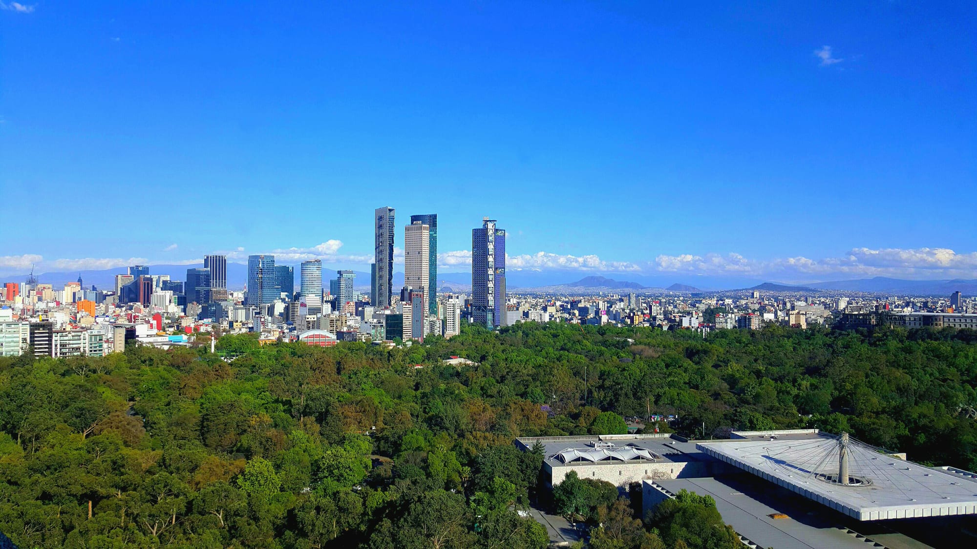
Skyscrapers along Paseo de la Reforma rising beyond the dense green woods of Chapultepec Park, with mountains on the horizon

Mexico City & the Centre, Mexico

Mexico City

The towers of Paseo de la Reforma seen over Chapultepec Park in Mexico City. (Jonathan Salvador / Wikimedia Commons · CC BY-SA 4.0)

Mexico's capital, at 2,240 metres in the Valley of Mexico, built on the ruins of the Aztec island city of Tenochtitlan. Founded around 1325 and rebuilt by the Spanish after 1521, it is the oldest capital in the Americas and now the centre of a metropolitan area of nearly 22 million — a city of colonial palaces, great museums, old lake villages and street food.

Neighbourhoods

  • Centro Histórico
    • First-time visitors
    • Historic district
    • Close to public transport

    The old heart of the city, built by the Spanish on the ruins of Tenochtitlan and stretching from the Zócalo west to the Alameda Central. Its 668 blocks hold the cathedral, the National Palace, the Templo Mayor and dozens of museums, and it is a UNESCO World Heritage Site.

    Open in Maps
  • Roma
    • Best for food
    • Nightlife
    • Architecture

    A neighbourhood of early 20th-century mansions and tree-lined streets south-west of the centre, now one of the city's main areas for restaurants, cafés, galleries and bars.

    Open in Maps
  • Condesa
    • Best for food
    • Parks
    • Nightlife

    Roma's neighbour, laid out around leafy parks and avenues, with Art Deco apartment buildings and a dense mix of cafés, restaurants and bars.

    Open in Maps
  • Juárez and the Zona Rosa
    • Nightlife
    • Shopping
    • LGBT scene

    Just west of the historic centre beside Paseo de la Reforma, the Zona Rosa is known for shopping, nightlife, the city's LGBT community and a recently established Korean community.

    Open in Maps
  • Polanco
    • Upmarket stays
    • Museums
    • Fine dining

    An affluent district north of Chapultepec Park, with luxury shops, many of the city's upmarket restaurants and hotels, and the Museo Soumaya in Nuevo Polanco just to the north.

    Open in Maps
  • Coyoacán
    • Historic district
    • Museums
    • Quiet and residential

    A formerly separate colonial town in the south of the city, absorbed by the sprawl but keeping its own character, with plazas, cobbled streets, the Frida Kahlo Museum and the university campus nearby.

    Open in Maps
  • San Ángel
    • Historic district
    • Quiet and residential

    Another old town swallowed by the city, west of Coyoacán, with colonial churches such as El Carmen and old mansions, many now galleries and restaurants.

    Open in Maps

Things to do

The historic centre

  • Zócalolandmark

    The main square, the Plaza de la Constitución, the stage for national celebrations and protests.

    Open in Maps
  • Metropolitan Cathedrallandmark

    The seat of the archdiocese, built in sections between 1573 and 1813 on one side of the Zócalo.

    Open in Maps
  • National Palacelandmark

    The seat of the federal executive on the east side of the Zócalo, whose stairway and courtyard walls carry Diego Rivera's murals of Mexican history.

    Open in Maps
  • Templo Mayormuseum

    The excavated remains of the great twin temple of Tenochtitlan beside the cathedral, with a museum of finds from the site.

    Open in Maps
  • Palacio de Bellas Arteslandmark

    The white marble palace of the arts at the Alameda Central, built between 1904 and 1934, with murals by Mexico's great muralists and a theatre for opera and ballet.

    Open in Maps
  • Torre Latinoamericanaviewpoint

    The 166-metre tower of 1956, Mexico's tallest building until 1982, which came through the 1985 earthquake undamaged; its observation deck on the 44th floor looks out over the centre.

    Open in Maps

Chapultepec and Reforma

  • Chapultepec Parkpark

    The great wooded park on the west side of the centre, holding a hilltop castle, lakes, a zoo and several of the country's major museums.

    Open in Maps
  • National Museum of Anthropologymuseum

    The largest and most visited museum in Mexico, with halls on every major civilisation of ancient Mexico, the Aztec hall at its centre.

    Open in Maps
  • Chapultepec Castlemuseum

    A palace on the hill at the heart of the park, once a military academy and the residence of the Emperor Maximilian, now the National Museum of History, with wide views of the city.

    Open in Maps
  • Angel of Independencelandmark

    The golden winged victory on its column on Paseo de la Reforma, the city's most recognisable monument and the place where crowds gather to celebrate.

    Open in Maps
  • Museo Soumayamuseum

    A private art museum founded by Carlos Slim, whose curving building of 2011 at Plaza Carso holds sculpture, Mexican art and European old masters.

    Open in Maps

The south: Coyoacán, the university and Xochimilco

  • Frida Kahlo Museummuseum

    The Casa Azul, the blue house in Coyoacán where the painter was born and lived, kept with her studio, belongings and works.

    Open in Maps
  • Ciudad Universitarialandmark

    The main campus of the national university, UNAM, designed by Mario Pani and Enrique del Moral, with the Central Library, the Olympic Stadium and museums; it is on the UNESCO World Heritage list.

    Open in Maps
  • Xochimilconeighborhood

    The southern borough where the last canals and chinampa islands of the old lake survive, explored on brightly painted trajinera boats; it is a UNESCO World Heritage Site.

    Open in Maps

Markets

  • La Merced Marketmarket

    The largest traditional retail food market in the city, on the eastern edge of the historic centre, in a district that has been a trading quarter since early colonial times.

    Open in Maps
  • San Juan Marketmarket

    A market in the historic centre that specialises in gourmet and unusual foods, from game meats to imported cheeses, supplying chefs and restaurants.

    Open in Maps

Music, sport and nights out

  • Plaza Garibaldiattraction

    The square north of the centre where mariachi bands gather to be hired to play, long the centre of mariachi music in the capital.

    Open in Maps
  • Arena Méxicoattraction

    The 'cathedral of lucha libre', the indoor arena in Colonia Doctores where Mexico's masked wrestlers fight for the CMLL promotion.

    Open in Maps
  • Estadio Aztecaattraction

    The great football stadium in Coyoacán, now officially Estadio Banorte, which hosted the opening match of the 2026 World Cup and is the only stadium to have hosted three World Cups.

    Open in Maps
  • Basilica of Our Lady of Guadalupelandmark

    The shrine at the hill of Tepeyac in the north of the city, holding the image of the Virgin of Guadalupe and visited by some twenty million pilgrims a year.

    Open in Maps

Short trips from the city

  • Teotihuacanlandmark

    The ruins of the great ancient city of the Pyramid of the Sun, the Pyramid of the Moon and the Avenue of the Dead, a UNESCO World Heritage Site.

    Open in Maps

Seasonal events

  • Vive LatinoMarch or April

    One of Mexico's most important music festivals, gathering bands from across Ibero-America, with a focus on alternative music.

  • Mexico City Marathonlate August or early September

    A marathon through the streets of the capital, run at high altitude.

  • The Grito15 September, the eve of Independence Day

    The president re-enacts Miguel Hidalgo's call to arms from the balcony of the National Palace, ringing his bell, before a packed Zócalo.

  • Day of the Dead Paradearound the Day of the Dead, at the start of November

    A parade of floats, giant figures and costumed Catrinas along Paseo de la Reforma, begun after a fictional parade appeared in a 2015 film; in 2025 it drew about 1.5 million people.

  • Feast of Our Lady of Guadalupe12 December

    Millions of pilgrims converge on the basilica at Tepeyac around the feast day of the Virgin.

Eat and drink

Long-standing places and food districts in Mexico City. Hours, ratings and directions come from your maps app, always current.

Mexico City classics

  • Taquerías of Roma and Condesaneighborhood

    Taco stands and taquerías serving the city's signature taco al pastor, pork marinated in chillies and cooked on a vertical spit.

    Open in Maps
  • Pulquerías of the historic centreneighborhood

    Working-class bars serving pulque, the fermented sap of the maguey and the old drink of the Aztecs, sometimes flavoured with fruit.

    Open in Maps

Food markets

  • La Merced Marketmarket

    The city's biggest traditional food market, with fruit, chillies, dried goods and food stalls across a large hall.

    Open in Maps
  • San Juan Marketmarket

    Known for game, unusual meats, fine cheeses and imported products, sold to the city's chefs and to anyone curious.

    Open in Maps
  • Coyoacán's centreneighborhood

    Cafés, ice-cream shops and snack stalls around the plazas of the old town, busy with families at weekends.

    Open in Maps

Experience Mexico City

History

Mexico City began as Tenochtitlan, founded by the Mexica on islands in Lake Texcoco around 1325. Over the next two centuries it grew to dominate the other city-states of the Valley of Mexico, at the centre of a tribute empire. Hernán Cortés laid siege to it in May 1521, and Cuauhtémoc surrendered that August. The Spanish razed much of the city and rebuilt it on their own plan around the main square, raising the cathedral and the palaces of the viceroy and archbishop over the Aztec ceremonial centre. As capital of New Spain the city spread over the drained lakebed, which leaves it sinking today.

After independence in 1821 it became the capital of independent Mexico, was taken by US troops in 1847 and was dressed up by the Emperor Maximilian, who laid out the avenue now called Paseo de la Reforma. The city had about 500,000 people in 1900. Growth exploded from the 1960s: the metro opened in 1969, and the population more than doubled between 1960 and 1980 to nearly 9 million, spilling into the State of Mexico.

On 19 September 1985 an earthquake struck the city, killing around 10,000 people, and the government's response was widely criticised. On the same date in 2017 another earthquake killed 370 people in central Mexico. In 2016 the Federal District was renamed Mexico City, and in 2017 it adopted its own constitution. In June 2026 the Estadio Azteca hosted the opening match of the World Cup, Mexico against South Africa, making it the first stadium to host three tournaments.

Culture & Customs

Mexico City is the country's cultural capital. A resident is a chilango, a word once used as an insult and now worn with pride. The city has about 170 museums, among the most of any city in the world, from the National Museum of Anthropology to small house museums, and its walls carry the murals of Diego Rivera, José Clemente Orozco and David Alfaro Siqueiros. UNESCO named it a City of Design in 2017.

Music fills the streets and squares: mariachis wait to be hired in Plaza Garibaldi, the Palacio de Bellas Artes stages opera and folk ballet, and festivals such as Vive Latino draw bands from across Ibero-America. Football is followed with passion — the city's derbies between América, Cruz Azul and Pumas of the national university are the big local rivalries — and lucha libre, masked wrestling, is a weekly spectacle at the Arena México. Mexico City's congress banned traditional bullfighting in 2025.

The calendar is crowded. On the night of 15 September the president gives the Grito of independence from the National Palace before a packed Zócalo; the Day of the Dead brings altars, a huge parade along Paseo de la Reforma and candlelit vigils in old villages such as Mixquic; and in December millions of pilgrims walk to the Basilica of Guadalupe. About four in five residents are Catholic. The city also draws newcomers from across Mexico and abroad, and it is home to the largest population of Americans living outside the United States.

Daily Life

Mexico City proper had about 9.2 million people at the 2020 census, and Greater Mexico City, which takes in 60 municipalities of the State of Mexico and one in Hidalgo, about 21.8 million, making it one of the largest metropolitan areas in the world. The city alone produces about 16 per cent of Mexico's economy: government, finance, media, corporate headquarters, universities and a huge informal sector of street vendors and tianguis, the mobile street markets that set up in different neighbourhoods each day of the week.

The city is divided into sixteen boroughs, from the dense centre to the hills and villages of the south. Wealthier residents cluster in Polanco, Condesa, Roma and the south-west; working-class districts and informal settlements spread to the east and into the State of Mexico, and millions commute long distances by metro, minibus and the newer cable cars and suburban trains.

The pressures are environmental. The soft lakebed is sinking as groundwater is pumped out, which worsens summer flooding, and although air pollution has fallen sharply since the 1990s, ozone remains well above safe limits. Roma and Condesa have seen gentrification and rising rents, sped up by remote work after the COVID-19 pandemic. In April 2026 a new rail line opened from Buenavista station to the Felipe Ángeles airport.

Food

Tacos have been the city's everyday food since the 19th century, and its signature is the taco al pastor, pork marinated in chillies and cooked on a vertical spit, a method brought by Lebanese immigrants. The streets add tlacoyos, thick oval masa cakes stuffed with beans, fava beans or cheese; quesadillas; the guajolota, a tamal in a bread roll; and esquites, corn kernels served in a cup. Stalls and vendors sell them throughout the day.

Barbacoa, meat slow-cooked in an earth oven under maguey leaves, is an old favourite: tacos de barbacoa were the ones most often mentioned in the 19th century. Many neighbourhoods have their own mercado, and La Merced is the largest food market; La Nueva Viga, in the Central de Abastos wholesale complex, is one of the biggest seafood markets in the world. The main meal, the comida, comes in mid-afternoon, and many workers eat a set-price comida corrida in a small fonda.

Pulque, the fermented sap of the maguey, was drunk by the Aztec nobility and priesthood and survives in working-class pulquerías, though beer overtook it in the 20th century. At the other end of the scale, restaurants serve the regional cuisines of all 31 states, and in 2024 seven of the city's restaurants received Michelin stars.

Planning tools

Budget

Mexico City is good value for a world capital. Street food, the metro and many museums cost little, and hostels and simple hotels are plentiful in the historic centre; Polanco, Condesa and Roma have the most expensive hotels and restaurants. Prices rise for big events such as concerts, the Formula One race and major football matches.

Daily Budget Midrange
USD 85–200 (mid-range hotel, restaurant meals, museum entries and ride-hailing)
Daily Budget Shoestring
USD 35–60 (hostel or simple hotel, street food and fondas, metro and Metrobús)

Many museums have free entry on Sundays, in some cases only for Mexican residents, and a set-price comida corrida lunch is the cheapest good sit-down meal.

Best Time to Visit

October to April is the dry season, with clear skies and the best chance of seeing the volcanoes; nights can be cold in December and January. March to May is the warmest stretch, and air quality is generally best in the rainy season. From about May to October afternoon storms are frequent, though mornings are often fine.

Suggested Number of Days

The city is enormous and its sights are spread across distant boroughs, so a first visit needs four or five days. Add two or three for excursions to the ancient sites and towns of the surrounding states. Traffic and the altitude both make a slower pace sensible.

First Visit
4–5 days
With Surroundings
6–8 days

Transportation

The metro, opened in 1969, has just over 200 kilometres of route and is the second-largest rapid transit system in North America after the New York City Subway; it is the fastest way across the city but very crowded at rush hour. The Metrobús rapid-bus lines, the light rail to Xochimilco, the Cablebús cable cars in the hilly outskirts and the Ecobici bike share fill gaps, and ride-hailing apps are widely used. Traffic is heavy, and cars are kept off the road on certain days according to their number plates.

Avoid the metro in the morning and evening rush if possible, and take apps or registered taxis rather than hailing cabs on the street.

Airport & Station Connections

Mexico City International Airport, the main airport and Aeroméxico's hub, lies 5 kilometres east of downtown, linked by metro, Metrobús and taxi. Felipe Ángeles International Airport, the newer secondary airport opened in 2022, is in Zumpango, 35 kilometres north of the city, with a rail link from Buenavista station since April 2026. First-class buses reach the whole country from four long-distance terminals.

Walkability

The historic centre, Roma, Condesa, Polanco and Coyoacán are pleasant on foot, with many pedestrian streets and leafy avenues, but the distances between them are long, and the metro or a taxi is needed to link them. The altitude makes walking more tiring at first, and the soft lakebed ground leaves some pavements uneven.

Safety

Safety varies enormously by state and even neighbourhood. The central neighbourhoods most visitors use — the historic centre, Roma, Condesa, Coyoacán and Polanco — are generally safe by day with ordinary care, but pickpocketing on the metro and phone snatching are common, and some outer districts have high crime. The city sits in an earthquake zone: the earthquake of 19 September 1985 killed around 10,000 people, and one on the same date in 2017 killed 370 in central Mexico. Altitude and ozone pollution can affect people with breathing or heart conditions.

Keep phones out of sight on the metro, use apps or registered taxis rather than hailing cabs, and take the altitude gently at first. Check current official travel advice before travelling.

Climate

A subtropical highland climate, mild for its tropical latitude because of the altitude: the average annual temperature is 12–16°C depending on the borough. The rainy season runs from about May to October, with afternoon storms; the dry months are sunny, with cool nights.

Summer
mild with afternoon rain — about 22–27°C by day across the central highlands; the warmest stretch is March to May, before the rains
Winter
dry and sunny — about 18–23°C by day across the central highlands, with cold nights

Local Customs

Politeness matters: people greet with 'buenos días' or 'buenas tardes', shake hands or kiss on the cheek among friends, and use 'usted' with strangers and elders. Tipping is customary in restaurants and for guides. The comida, the main meal, is eaten in mid-afternoon, and dinner is late and lighter. Dress in the city is more formal than at the beach resorts.

Dress modestly in churches, especially the cathedral and the Basilica of Guadalupe, and be discreet with cameras during services.

Common Payment Methods

The currency is the Mexican peso. Cards and contactless payment are widely accepted in hotels, restaurants and shops, while markets, street stalls, small taxis and tips need cash. ATMs are everywhere; using those inside banks and shopping centres is safer.