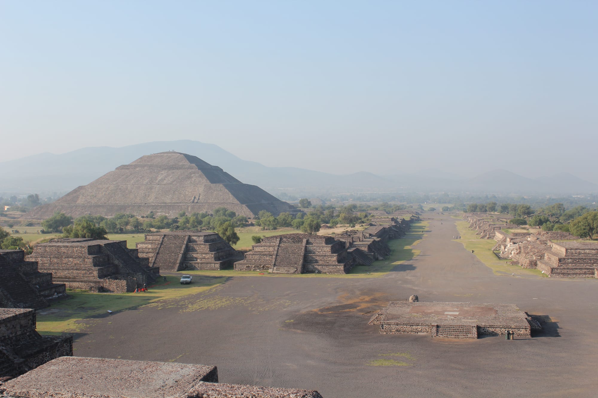
The broad Avenue of the Dead stretching south past stepped platforms, with the Pyramid of the Sun on the left and hazy hills beyond

Mexico City & the Centre, Mexico

San Juan Teotihuacán

The Avenue of the Dead and the Pyramid of the Sun at Teotihuacan, seen from the Pyramid of the Moon. (Arian Zwegers from Brussels, Belgium / Wikimedia Commons · CC BY 2.0)

A small farming town in the State of México, about 45 km north-east of Mexico City, that grew up around a 16th-century monastery beside the ruins of Teotihuacan, the great planned city of the Pyramids of the Sun and Moon. The archaeological zone, a UNESCO World Heritage Site since 1987, draws over a million visitors a year, while the town itself keeps a Monday market and its own festivals.

Neighbourhoods

  • Town centre
    • Local life
    • Markets

    The municipal seat, officially Teotihuacán de Arista, grew up around the former monastery of San Juan Evangelista. Its main plaza, the early 20th-century municipal market and the streets filled by the Monday market are where residents shop and eat, a short way from the ruins.

    Open in Maps
  • Around the archaeological zone
    • First-time visitors
    • Sightseeing

    The roads around the ruins' gates are lined with restaurants, souvenir sellers and a few places to stay, much of it built up haphazardly. The site itself reaches into neighbouring San Martín de las Pirámides, where the Pyramid of the Moon stands.

    Open in Maps

Things to do

The ancient city

  • Pyramid of the Sunlandmark

    The largest building in Teotihuacan and one of the largest in Mesoamerica, built about AD 200 on the Avenue of the Dead beneath the mountain Cerro Gordo.

    Open in Maps
  • Pyramid of the Moonlandmark

    The second-largest pyramid at the site, built in stages between about AD 100 and 450 at the northern end of the Avenue of the Dead, facing the Plaza of the Moon.

    Open in Maps
  • Avenue of the Deadlandmark

    The ancient city's central avenue, about 45 metres wide, lined with platforms, temples and elite residences, linking the Pyramid of the Moon with the Ciudadela.

    Open in Maps
  • Temple of the Feathered Serpentlandmark

    The third-largest pyramid at Teotihuacan, inside the great enclosed plaza of the Ciudadela, covered with some of the earliest known carvings of the feathered serpent; a sealed tunnel beneath it was found in 2003.

    Open in Maps
  • Palace of Quetzalpapálotllandmark

    A palace complex south-west of the Pyramid of the Moon, known for the carved reliefs in its courtyard, with surviving murals in the adjoining buildings.

    Open in Maps

The town

  • Monday marketmarket

    One of the most traditional tianguis in the Valley of Mexico, with hundreds of stalls set up every Monday between the archaeological site and the old monastery, selling mostly food.

    Open in Maps
  • Former monastery of San Juan Evangelistalandmark

    The monastery founded in 1548 that marks the origin of the modern town.

    Open in Maps

Short trips from the town

  • Acolmanattraction

    A neighbouring town to the south-west whose 16th-century Augustinian monastery still holds important art and architecture of the period.

    Open in Maps

Seasonal events

  • Feast of John the Baptistlate June

    The feast day of the town's patron saint.

  • Feast of Christ the Redeemer and the Obsidian FairJuly

    An eight-day festival with traditional dances such as the Aztecs, Santiagueros and Sembradores, held at the same time as a fair of obsidian crafts.

Eat and drink

Long-standing places and food districts in San Juan Teotihuacán. Hours, ratings and directions come from your maps app, always current.

Food districts and markets

  • Municipal marketmarket

    The permanent market, dating from the early 20th century, where local dishes such as barbacoa, mixiote and nopal preparations are served.

    Open in Maps
  • Monday tianguismarket

    The weekly street market, where most stalls sell foodstuffs and prepared dishes.

    Open in Maps
  • Restaurants around the ruinsneighborhood

    The roads around the site's gates have many restaurants serving visitors to the pyramids.

    Open in Maps

Experience San Juan Teotihuacán

History

Teotihuacan, a Nahuatl name often glossed as "the birthplace of the gods", was founded around 100 BCE, and at its height in the first half of the first millennium it was the largest city in the Americas, with perhaps 100,000 people. In Nahua mythology the Sun and the Moon were created here. Its major monuments were sacked and burned around AD 550, and the city faded over the following centuries; it predates the Aztec Empire by many centuries.

After the conquest the area was renamed San Juan Teotihuacan, and by the end of the 16th century it was an encomienda of Francisco de Verdugo Bazán. The modern town grew up around the monastery of San Juan Evangelista, founded in 1548; a report of 1580 recorded that most people spoke Nahuatl, with Otomi and Popoloca minorities. During the Revolution rival factions passed through and food grew scarce. Large excavations began in the early 20th century, including Manuel Gamio's work in the 1920s, and in 1987 the ancient city was declared a UNESCO World Heritage Site.

Development around the site has caused repeated controversy. In the mid-2000s a supermarket built in the Purificación district, in an outer zone of the site where such building was permitted, was opposed by conservationists, intellectuals and artists; it opened in November 2004, 2.4 km from the Pyramid of the Sun. In May 2021 bulldozing for an amusement park on the northern edge of the ruins was halted when federal forces seized the land. In 2008 the Vatican created the Diocese of San Juan Teotihuacan.

Culture & Customs

The town lives beside one of the most visited archaeological sites in Mexico — the second most visited in 2024, with more than 1.3 million visitors — and its seal shows the Pyramid of the Sun. Research at the site continues to change how the ancient city is understood: a tunnel sealed nearly 2,000 years ago was found beneath the Temple of the Feathered Serpent in 2003, and in October 2025 a partial decipherment of Teotihuacan writing was proposed.

Local religious festivals keep their own calendar. The feast of John the Baptist, the town's patron, falls in late June, and the eight-day feast of Christ the Redeemer in July brings traditional dances, among them the Aztecs, the Santiagueros and the Sembradores, together with the Obsidian Fair, a reminder that obsidian tools from Teotihuacan were once traded across Mesoamerica.

Newer events have joined them since the 2000s. A hot-air balloon festival has been held each year since 2005, drawing around 15,000 people and some twenty balloons, and balloon flights over the pyramids are offered to visitors. The Música para los Dioses rock festival, held since 2006, has brought dozens of bands and crowds of more than 20,000.

Daily Life

The municipality covers about 83 square kilometres and includes the town and some 115 other named communities; a little under half of its people live in the town itself. Despite the site's fame, agriculture employs the largest share of residents, about 48 per cent, followed by commerce and tourism together at about 32 per cent and a small industry processing food, drinks and other farm products. The countryside is semi-arid, with cactus, maguey and grasses on the dry ground and two rivers, the San Juan and the San Lorenzo, running through the town.

Tourism has not created a large industry. Few hotels stand near the site, and most people who earn a living from visitors sell souvenirs inside and outside its gates, in businesses that have grown up haphazardly. The supermarket that caused such controversy became an economic engine for the town, drawing shoppers from the surrounding area. Land around the ruins remains contested between development and protection.

Monday is market day, when hundreds of stalls fill the streets between the site and the old monastery, and the area is quiet again once the day visitors leave in the late afternoon.

Food

The food here is that of the farming country of the northern Valley of Mexico. Barbacoa, slow-cooked meat, and mixiote, meat steamed in a wrapper, are the dishes to look for, along with quail and many preparations of nopal, the prickly-pear cactus pad, which grows abundantly in the area.

The best places to find them are the permanent municipal market, which dates from the early 20th century, and the Monday tianguis, one of the most traditional in the Valley of Mexico, where most of the merchandise is food and prepared dishes. The tianguis is also known for its fruit and vegetables. The market was the scene of archaeological work in 2005, when new drains were laid inside the site's protected perimeter.

Around the ruins, restaurants cater to visitors arriving from Mexico City. The maguey that grows on the dry hillsides around the town is the plant from which pulque, the fermented drink of the region, is made.

Planning tools

Budget

The town is inexpensive: market meals and local buses cost little. Most visitors come on a day trip from Mexico City, and site entry, a guide or a tour from the capital make up most of the cost. Balloon flights over the site are the main extra expense.

Daily Budget Midrange
USD 85–200 (mid-range room near the site, restaurant meals, a guide or tour, site entry)
Daily Budget Shoestring
USD 35–60 (simple guesthouse, market food, buses from Mexico City)

The archaeological zone is among the busiest in Mexico; arriving early or on a weekday means fewer people on the pyramids.

Best Time to Visit

October to April is dry and clear across the central highlands, though the area can have frosts from October to March and nights are cold. Summer brings the rains. The town's own festivals fall in late June and July, and the market is held every Monday.

Suggested Number of Days

Most visitors come for a single day from Mexico City. An overnight stay allows an early start before the crowds and a look at the town and its market as well.

First Visit
1 day
With Surroundings
2 days

Transportation

The archaeological zone is large and walked on foot. Local buses and taxis link the town, the site's entrances and neighbouring San Martín de las Pirámides.

Carry water and sun protection for the long walks on the site.

Airport & Station Connections

The town lies about 45 km north-east of Mexico City. Buses run from the capital's northern bus terminal, and many visitors come on organised tours or by car. The nearest airports are those of Mexico City.

Walkability

The ancient city's main monuments are linked by the Avenue of the Dead, about two kilometres long, and seeing them involves a lot of walking in the sun. The town centre is small and easy on foot.

Safety

Safety varies enormously by state and even neighbourhood. The surrounding State of México has some of the country's highest rates of robbery. On 20 April 2026 a gunman shot and killed a Canadian visitor and wounded several others at the pyramids before killing himself.

Travel by day, use registered buses, taxis or apps, and keep valuables out of sight. Check current official travel advice before travelling.

Climate

The climate is temperate and semi-arid, with rain in summer and frosts possible from October to March. The figures below are for Mexico City.

Summer
mild with afternoon rain, about 22–27°C by day in Mexico City
Winter
dry and sunny, 18–23°C by day in Mexico City, with cold nights near freezing at altitude

Local Customs

This is a small, mostly agricultural town, and churches, festivals and the Monday market are part of local life. Modest dress is expected in churches. A tip is customary in restaurants and for guides.

Ask before photographing people at the market or during festival dances.

Common Payment Methods

The currency is the Mexican peso. Market stalls, small restaurants and local buses need cash; cards are accepted at larger restaurants and hotels. Bring cash from Mexico City or use a machine inside a bank.