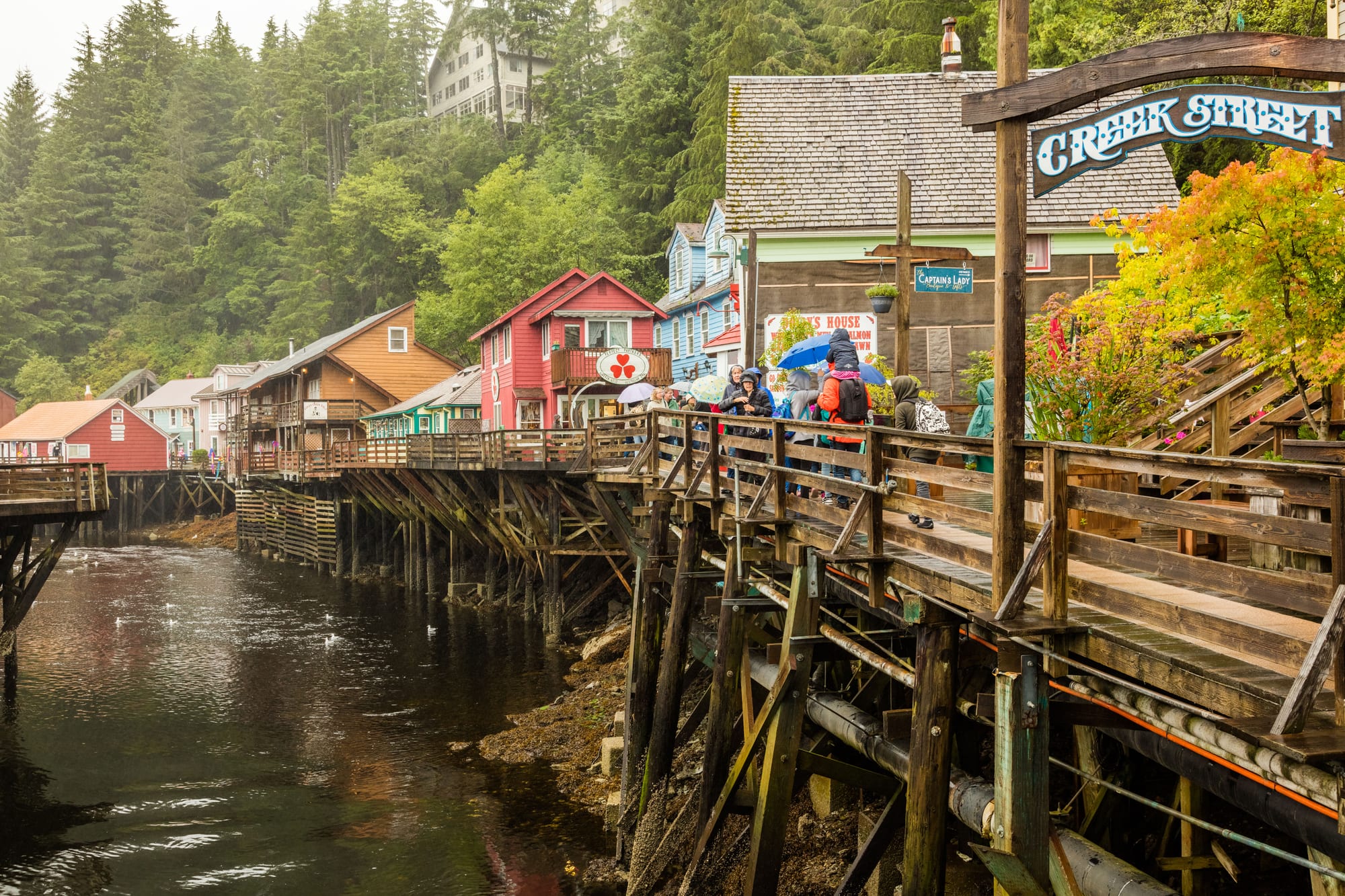
Colourful wooden houses on stilts along the Creek Street boardwalk above a creek, with forested hills behind

Alaska, United States

Ketchikan

The Creek Street boardwalk on its stilts above Ketchikan Creek, the town's former red-light district. (Diego Delso / Wikimedia Commons · CC BY-SA 4.0)

Alaska's southeasternmost major town, strung along the Tongass Narrows on Revillagigedo Island at the foot of Deer Mountain. A Tlingit fish camp became a salmon saltery in 1885 and a cannery and timber town after it; today a historic downtown of boardwalks, totem poles and fishing boats fills with cruise passengers through the summer and empties into a wet, quiet winter.

Neighbourhoods

  • Downtown and the cruise docks
    • First-time visitors
    • Historic district
    • Shopping

    The compact old centre on the waterfront, a National Historic Landmark District, where the big cruise ships tie up alongside. Galleries of Native art, souvenir shops, museums and seafood counters fill the blocks between the docks and the foot of Deer Mountain, and the streets are packed on busy ship days.

    Open in Maps
  • Creek Street
    • Historic district
    • Photography

    A boardwalk on stilts along the east side of Ketchikan Creek, a few blocks from the docks. Once the town's red-light district, it is now lined with small shops in brightly painted wooden houses, and in summer salmon gather below the bridges at the creek mouth.

    Open in Maps
  • West End
    • Quiet and residential
    • Local life

    The residential district north-west of downtown, climbing the hillside above the narrows, with houses reached by steep streets and stairways and the Ketchikan campus of the University of Alaska Southeast on its upper side.

    Open in Maps
  • Saxman
    • Native culture
    • Totem poles

    A small separate town just south-east of Ketchikan along the Tongass Highway, the headquarters of the Organized Village of Saxman, a federally recognised Tlingit tribe, and home to Saxman Totem Park.

    Open in Maps

Things to do

Totem poles and Native heritage

  • Totem Heritage Centermuseum

    A museum run by the city since 1976 that preserves 19th-century totem poles rescued from abandoned Tlingit and Haida village sites near Ketchikan.

    Open in Maps
  • Saxman Totem Parkpark

    A park of totem poles brought from deserted Tlingit villages in the region or recarved by Tlingit carvers under the Civilian Conservation Corps in the 1930s.

    Open in Maps
  • Raven Stealing the Sun totem polelandmark

    A pole carved in 1982 by Dempsey Bob and Stanley Bevan for the Tongass Historical Museum, telling the story of Raven bringing daylight to humankind.

    Open in Maps
  • Totem Bight State Historical Parkpark

    A small state park on the shore north of town, with poles recarved from older originals, reached along the North Tongass Highway.

    Open in Maps

Downtown and museums

  • Creek Streetlandmark

    The boardwalk of wooden houses on stilts above Ketchikan Creek, the former red-light district, now lined with small shops.

    Open in Maps
  • Southeast Alaska Discovery Centermuseum

    A Forest Service visitor centre with exhibits on the ecology, economy and cultures of Southeast Alaska and its temperate rainforest.

    Open in Maps
  • Tongass Historical Museummuseum

    The town's history museum on Dock Street, with the Raven Stealing the Sun pole standing outside.

    Open in Maps

Walks and the outdoors

  • Ketchikan International Airporttransit hub

    The airport on Gravina Island across the Tongass Narrows, reached from town by a seven-minute ferry.

    Open in Maps
  • Deer Mountaintrail

    The 3,001-foot peak behind downtown, climbed by a strenuous trail of about 2.75 miles through rainforest, muskeg and alpine meadow.

    Open in Maps

Short trips from the town

  • Misty Fjords National Monumentpark

    A vast wilderness of fjords, sea cliffs and waterfalls in the Tongass National Forest, reached from Ketchikan by boat or floatplane.

    Open in Maps

Eat and drink

Long-standing places and food districts in Ketchikan. Hours, ratings and directions come from your maps app, always current.

Ketchikan classics

  • Seafood on the downtown waterfrontneighborhood

    Salmon, halibut, rockfish, lingcod and Dungeness crab from local waters, served as chowder, fish and chips and grilled fillets in the cafés and restaurants near the docks.

    Open in Maps
  • Burger Queenrestaurant

    A popular local take-out on Water Street, just past the downtown tunnel, known above all for its halibut sandwich.

    Open in Maps

Food districts

  • Filipino kitchensneighborhood

    Ketchikan's sizeable Filipino community supports several restaurants serving Filipino dishes, some alongside an American menu.

    Open in Maps

Experience Ketchikan

History

Ketchikan Creek was a summer fish camp for the Tlingit for generations before a town grew up beside it. Its name comes from the Tlingit name for the creek, Kitschk-hin, now written Kichx̱áan, whose meaning is uncertain. In 1885 Mike Martin, sent north by an Oregon canning company to look for prospects, set up a saltery and a general store with George Clark, a Nova Scotian. The town was incorporated in 1900, and because consolidations elsewhere dissolved older city governments it is now the oldest incorporated city still existing in Alaska. Its strategic position at the southern tip of the Inside Passage earned it the name "Alaska's first city".

Canneries made the town in the early 20th century, and civic boosters took to calling it the "Salmon Capital of the World". The houses on stilts along Creek Street became a notorious red-light district, and during Prohibition a row of speakeasies. In the 1930s the Civilian Conservation Corps had Native carvers recarve old totem poles from abandoned villages, the origin of the totem parks at Saxman and Totem Bight.

From 1954 a large pulp mill at Ward Cove, just north of town, dominated the economy. It closed in 1997 after timber harvests in the Tongass National Forest were reduced, ending more than 500 year-round jobs, and a federal investigation had found it had polluted the cove's waters. Cruise tourism grew to fill much of the gap: in 2018 more than a million passengers came ashore from over 500 ship calls.

Culture & Customs

Ketchikan sits where three Alaska Native cultures meet — Tlingit, Haida and Tsimshian — and the totem pole is the town's emblem. It claims the world's largest collection of standing totem poles, found across downtown and in four main places: Saxman Totem Park, Totem Bight, Potlatch Park and the Totem Heritage Center, where 19th-century poles rescued from abandoned villages are preserved. The Chief Kyan pole in Whale Park downtown appears in the background images of most US passports. Several of the town's galleries specialise in Native-design art, and Saxman is the seat of a federally recognised Tlingit tribe.

Beyond Native art, the town has drawn painters and photographers inspired by its forests and water, and local galleries carry their work. A sizeable Filipino community is part of everyday life, and Tagalog is the most common first language after English. Summer brings a lumberjack show near Ketchikan Creek, staged between May and September.

Life runs on boats and weather. People fish for the table as well as for a living, talk about the rain with resigned pride, and take the quiet of winter after a summer of crowds as part of the bargain. A long-running school exchange links the town with Kanayama, now part of the city of Gero in Japan.

Daily Life

The city had about 8,200 people at the 2020 census, and the Ketchikan Gateway Borough around it about 13,900; many residents of the suburbs along the Tongass Highway live outside the city limits but think of themselves as Ketchikan people. The terrain is steep and forested, so the town is long and narrow, with most homes along the waterfront or within a few blocks of it, and Deer Mountain rising straight behind downtown.

The economy rests on government services, tourism and commercial fishing. The Tongass National Forest is run from the Federal Building downtown, the Alaska Marine Highway ferry system has its headquarters here, the Coast Guard keeps a large base south of the centre, and the town's shipyard won a state contract in 2014 to build two new Alaska Marine Highway day ferries. Employment swells in summer and peaks in July, when several cruise ships can be in port at once and downtown is crowded from morning to evening.

Winter is dark, wet and quiet, and life goes on in the West End, the harbours and along the highway. The town depends on planes and ferries for everything, including the short ferry ride to its own airport across the narrows, and on barges and planes for most of its goods.

Food

Seafood is the local food. Salmon is landed in quantity, but many local fishermen prefer halibut, and rockfish, lingcod and Dungeness crab come from nearby waters too. Although the fishing industry is smaller than it once was, large amounts of salmon are still landed, processed and shipped from Southeast Alaska every year. King crab, by contrast, is not fished near Ketchikan — on local menus it has been frozen and flown in from far to the north and west — so the sweet, smaller Dungeness, known locally as "Dungies", is the fresher choice.

Downtown cafés serve chowder, fish and chips and halibut in many forms, and the halibut sandwich from Burger Queen, a take-out on Water Street, is a local institution. Filipino restaurants, some serving Filipino dishes alongside an American menu, reflect the town's large Filipino community, and there are Mexican and Italian kitchens downtown as well.

Wild Alaskan salmon, famous far beyond the state, remains the town's signature fish.

Planning tools

Budget

Ketchikan shares Alaska's high prices: food and most goods arrive by barge or plane, and rooms are limited and in demand through the summer cruise season. Most of downtown can be seen on foot for little, but boat trips, floatplane flights and fishing charters are the big costs.

Daily Budget Midrange
USD 300–550 (hotel or bed and breakfast, restaurant meals, a boat trip or floatplane tour)
Daily Budget Shoestring
USD 120–200 (hostel bed or campground, supermarket food and take-out seafood, local buses)

Rooms are few in summer, so book early; the waterfront, Creek Street and the totem poles around downtown cost nothing to see.

Best Time to Visit

Cruise ships call from early May to late September, the months with the mildest weather, salmon in the creeks and every tour running. July and August are the warmest and the busiest. From autumn to spring the town is quiet and some attractions keep shorter hours, and the heaviest rain falls in autumn and winter.

Suggested Number of Days

Most cruise passengers have only a few hours, which covers the compact centre. One or two days allow a fuller look at the town and its nearer surroundings; three or four suit those who want time on the water or in the forest, with spare time for flights grounded by weather.

First Visit
1–2 days
With Surroundings
3–4 days

Transportation

Ketchikan is not connected by road to the rest of Alaska. Within the borough the Tongass Highway runs north and south along the narrows, and local buses cover it, with a free downtown loop in the cruise season. Taxis serve the whole road, and floatplanes and boats reach the islands and inlets beyond.

Floatplane and boat trips depend on the weather, so leave some slack in plans.

Airport & Station Connections

Ketchikan International Airport is on Gravina Island, across the Tongass Narrows from town, and has no road link: passengers cross on a seven-minute ferry. Alaska Airlines flies nonstop to Seattle in about an hour and a half, and to Juneau and other Southeast towns. Alaska Marine Highway ferries call on the Inside Passage route, at a terminal about 2 miles north of downtown, and most visitors arrive by cruise ship.

Walkability

Downtown is small and easily walked from the cruise docks, with Creek Street a few blocks away; streets are steep, with stairways up the hillsides. The rest of the town stretches for miles along the waterfront, so the totem parks and trailheads outside the centre need a bus, taxi or car. Rain gear is essential.

Safety

Crime against visitors is low. The main hazards are the weather and the outdoors: heavy rain, slippery boardwalks and trails, cold water, bears in the forest, and small planes and boats that depend on conditions.

For most visitors the US is safe, with the main risks being petty theft and car break-ins in tourist areas of some cities, road accidents over long distances, extreme weather, and the hazards of the outdoors. Carry waterproofs, keep to trails and make noise in bear country. Check current official travel advice before travelling.

Climate

A mild maritime climate of heavy cloud, high humidity and rain in every month — about 150 inches a year, falling hardest in autumn and winter — which has given the town the nickname 'Rain Capital of Alaska'. Clear, frigid spells come only when cold air spills over the mountains from the Yukon.

Summer
mild — August days average about 65°F, with nights around 53°F
Winter
chilly and wet — January days average about 40°F, with nights just below freezing

Local Customs

Tipping follows the US norm of roughly 18–22 per cent in restaurants. Dress is casual and practical, and rain jackets are everyday wear. Totem poles and Native art belong to living Tlingit, Haida and Tsimshian traditions; buying from Native artists and asking before photographing people is appreciated.

The legal age for alcohol is 21 and identification is asked for. Treat totem poles and clan houses with respect and do not climb on them.

Common Payment Methods

The currency is the US dollar. Cards and contactless payment are accepted almost everywhere downtown, and ATMs are easy to find. Alaska has no state sales tax, but local taxes are added at the till.