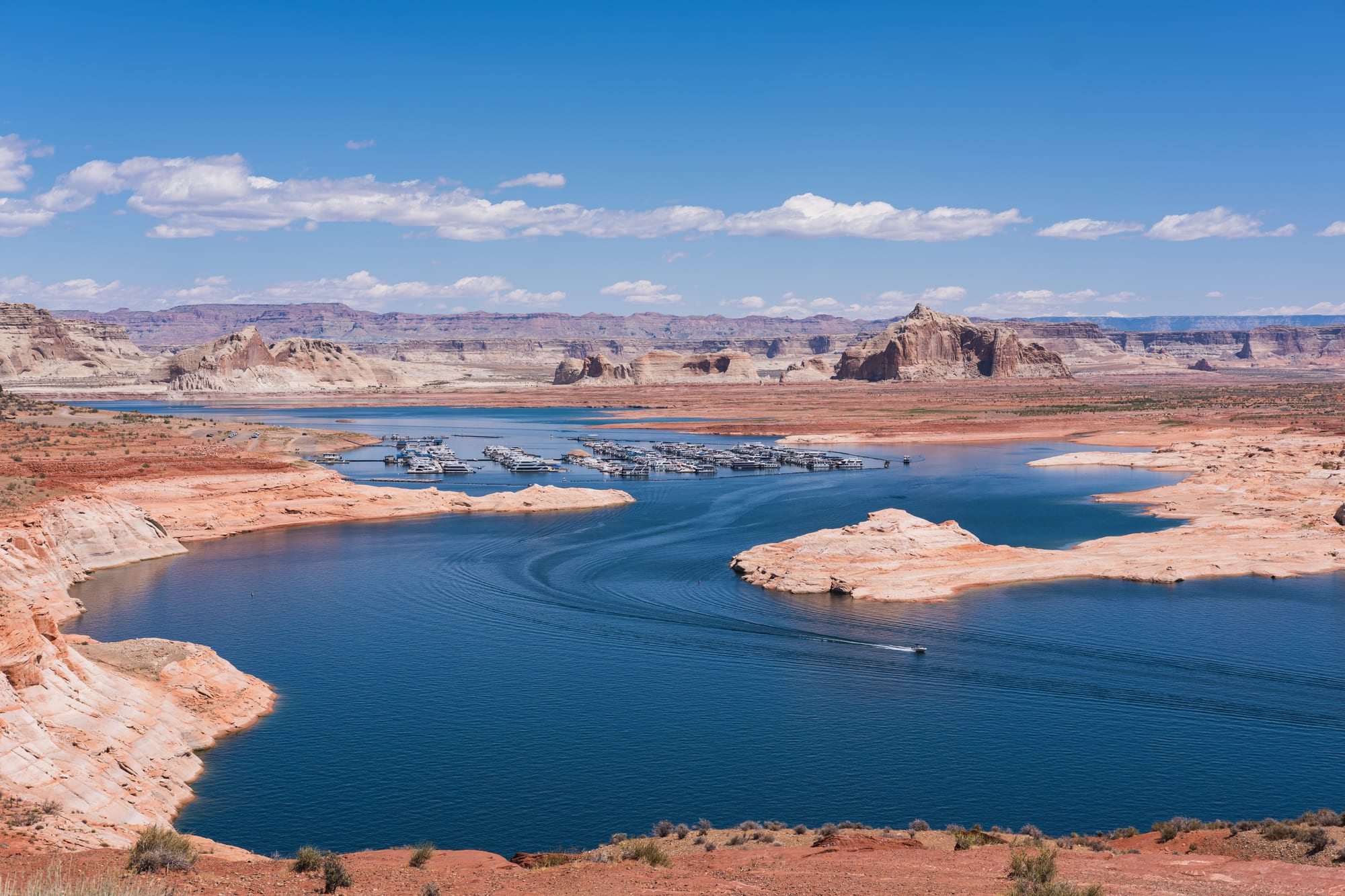
Deep blue water of Lake Powell winding between pale sandstone shores, with sandstone formations beyond

The Southwest, United States

Page

Lake Powell seen from Wahweap Overlook near Page. (Christian David / Wikimedia Commons · CC BY-SA 4.0)

A small city on Manson Mesa in northern Arizona, beside Lake Powell and the Glen Canyon Dam. It was founded in 1957 as a camp for the workers who built the dam, on land exchanged with the Navajo Nation. Today it is the base for boating on the lake and for visits to Horseshoe Bend and the slot canyons of Antelope Canyon.

Neighbourhoods

  • Lake Powell Boulevard
    • First-time visitors
    • Best for food
    • Nightlife

    The main street of the small grid town on top of the mesa, lined with motels, restaurants, bars, tour offices. Almost everything a visitor needs is on or just off it.

    Open in Maps
  • Wahweap and the lake shore
    • Boating
    • Camping
    • Views

    The lakeside area north-west of town near the Utah border, inside Glen Canyon National Recreation Area, with the Wahweap marina, a campground and RV park, houseboat rentals and overlooks across the bay.

    Open in Maps

Things to do

Canyons and viewpoints

  • Antelope Canyonattraction

    Slot canyons carved from Navajo Sandstone by flash floods on Navajo land east of LeChee, in Lake Powell Navajo Tribal Park; they are visited only on guided tours, in part because summer rain can flood them quickly.

    Open in Maps
  • Horseshoe Bendviewpoint

    A horseshoe-shaped meander of the Colorado River about 4 miles south-west of town, seen from a cliff-top overlook 1,000 feet above the water at the end of a 1.5-mile round-trip walk.

    Open in Maps

The lake and the dam

  • Glen Canyon Damlandmark

    The 710-foot concrete arch-gravity dam on the Colorado River, built by the Bureau of Reclamation from 1956 to 1966, which created Lake Powell and the town itself.

    Open in Maps
  • Lake Powellpark

    One of the largest reservoirs in the United States, flooding Glen Canyon on the Arizona–Utah border, named after John Wesley Powell, who explored the river in 1869; houseboats and marinas line its bays.

    Open in Maps
  • Glen Canyon National Recreation Areapark

    The National Park Service area around Lake Powell, with marinas, campgrounds and houseboat rentals, established in 1972.

    Open in Maps

Short trips from the town

  • Lees Ferryattraction

    A historic crossing of the Colorado River south-west of Page, once served by John D. Lee's ferry and since the 1920s the main point where the river's flow is measured to share its water between the states.

    Open in Maps
  • Rainbow Bridge National Monumentlandmark

    One of the largest natural arches in the world, 290 feet high, on the Utah side of Lake Powell; it is of cultural importance to several Native American tribes.

    Open in Maps
  • Vermilion Cliffs National Monumentpark

    A national monument just south of the Utah state line protecting the Paria Plateau, the Vermilion Cliffs, Coyote Buttes and Paria Canyon.

    Open in Maps

Eat and drink

Long-standing places and food districts in Page. Hours, ratings and directions come from your maps app, always current.

Page favourites

  • Big John's Texas BBQrestaurant

    A barbecue restaurant on Lake Powell Boulevard.

    Open in Maps
  • El Tapatiorestaurant

    A Mexican restaurant on the main street.

    Open in Maps
  • Lake Powell Boulevard barsneighborhood

    Most of the town's bars and drinking places line the southern part of the main street.

    Open in Maps

Experience Page

History

Page did not exist before the dam. In 1957 the government chose Manson Mesa, at about 4,300 feet and 600 feet above today's Lake Powell, as a housing camp for workers building the Glen Canyon Dam, and obtained a 17-square-mile site from the Navajo Nation in a land exchange. The settlement was first called Government Camp and then named after John C. Page, commissioner of the Bureau of Reclamation from 1936 to 1943. A new bridge across the canyon, finished in 1959, was built to bring in materials for the dam.

The dam was completed in 1966, and the rising water of Lake Powell flooded Glen Canyon, the series of sandstone gorges that John Wesley Powell had explored in 1869. Glen Canyon National Recreation Area was created around the lake in 1972, and Page was formally incorporated as a town in 1975. The town also became home to the coal-fired Navajo Generating Station, which powered the pumps sending Colorado River water to central and southern Arizona; it closed in 2019, and its three smokestacks were demolished in December 2020.

Tourism grew steadily, and in 1997 Antelope Canyon was opened to visitors on Navajo land beside the town. The same year a flash flood killed eleven tourists in Lower Antelope Canyon; warning and safety systems have since been improved, though the risk remains. In the 21st century a long drought has lowered Lake Powell repeatedly; in April 2022 it held under a quarter of its capacity, and it fell to that level again in the summer of 2026.

Culture & Customs

Page is a young, practical town shaped by water and power, and its culture is outdoors: boating and houseboat holidays on Lake Powell, fishing at Lees Ferry, hiking and photography in the canyons, and flights over the lake. More than three million people a year visit the recreation area, and the town is busiest in the summer boating season.

The Navajo Nation adjoins Page, and Navajo culture is part of daily life. Antelope Canyon lies within Lake Powell Navajo Tribal Park, run by the Navajo Nation's parks department, and visits are only on guided tours. Navajo dinner theatre in the area presents powwow dancing, flute playing and drumming. Visitors should remember that tribal land has its own laws, including a ban on alcohol, and that the Navajo Nation keeps daylight saving time while the rest of Arizona does not.

The landscape has drawn film-makers too: the 2001 comedy Evolution was shot in Page, and the canyons draw photographers from around the world. Lake Powell itself remains controversial — environmentalists have pushed to drain it and restore Glen Canyon to a free-flowing river, while others value it for water storage, power and recreation.

Daily Life

About 7,400 people lived in Page at the 2020 census, in a city covering about 16.6 square miles of mesa top and desert. The town sits on top of the mesa. It is a young population: at the 2020 census the median age was 32.9, and Navajo was the most reported ancestry, given by about two in five residents. Tourism is central to its economy, with the recreation area around the lake drawing more than three million visitors a year.

The closure of the Navajo Generating Station in 2019 removed one of the area's two great power plants. Life now follows the visitor seasons: crowded summers on the lake and at Antelope Canyon, and quiet winters.

Water and the lake's level are constant subjects. The 21st-century drought on the Colorado River has repeatedly lowered the lake. The small airport keeps a federally subsidised air service, a weekly newspaper, the Lake Powell Chronicle, covers local news, and a daily shuttle links the town with Las Vegas and the Grand Canyon.

Food

Page's food reflects its position as a road-trip stop at the edge of the Navajo Nation. Lake Powell Boulevard has restaurants, Mexican places such as El Tapatio and a Texas barbecue restaurant, Big John's, serving the visitors who fill the town each summer, and most of the town's bars are along its southern end. Big John's occupies a former gas station converted into a slow-cooked barbecue restaurant, and the Starlite, serving American and Chinese food, has been in business in Page for more than 30 years.

Navajo food is the local speciality. Fry bread — dough fried until puffed and golden — is eaten with honey or turned into the Navajo taco, topped with beans, meat, cheese and lettuce, and it turns up at powwows and community events across the Navajo Nation.

Campgrounds and houseboats give many visitors the chance to cook for themselves, and houseboat holidays on the lake are built around meals on board.

Planning tools

Budget

Page is a small town with a big visitor flow, so rooms are dear in the summer high season and good value in winter. The main extra costs are the guided tours of Antelope Canyon, which are the only way to visit, parking and entry fees at the national recreation area and Horseshoe Bend, and boat trips or houseboat rental on the lake.

Daily Budget Midrange
USD 200–380 (mid-range hotel, sit-down meals, an Antelope Canyon tour and park fees, hire car)
Daily Budget Shoestring
USD 90–150 (motel or campground, self-catering and casual meals, own car)

Book Antelope Canyon tours well ahead in summer, and buy an America the Beautiful pass if also visiting other national parks.

Best Time to Visit

Spring and autumn are the most comfortable for walking at Horseshoe Bend and touring the canyons. Summer is the busy season on the lake, with hot, very dry days. Winter is chilly but has very little snow and far fewer visitors.

Suggested Number of Days

One or two days cover the town's main viewpoints and a canyon tour. Three or four allow time on the lake by boat, or for the cliffs and canyons along the Utah border. Houseboat trips on the lake usually take longer.

First Visit
1–2 days
With Surroundings
3–4 days

Transportation

A car is the practical way to get around: the sights are spread along U.S. Route 89 and State Route 98 outside town. Antelope Canyon tours are arranged in town or through the tribal park office south of Page. A local nonprofit runs a small bus service to Wahweap and to towns on the Navajo Nation.

Arizona does not change its clocks in summer but the Navajo Nation does, so in summer Antelope Canyon tour times can be an hour different from the town's — check which time a booking uses.

Airport & Station Connections

Page Municipal Airport, 1 mile east of town, has a few scheduled flights subsidised under the federal Essential Air Service programme as well as sightseeing flights. Most visitors drive, on U.S. Route 89 from Flagstaff to the south or from Utah to the north, often as part of a longer road trip. A daily shuttle links Page with Las Vegas and with Grand Canyon Village.

Walkability

The town centre is small and walkable, with restaurants and motels close together along Lake Powell Boulevard, but all the main sights lie outside it. Horseshoe Bend involves a 1.5-mile round-trip walk on an exposed path from its car park.

Safety

For most visitors the US is safe, with the main risks being petty theft and car break-ins in tourist areas of some cities, road accidents over long distances, extreme weather, and the hazards of the outdoors. Around Page the hazards are natural: flash floods in slot canyons — eleven tourists died in Lower Antelope Canyon in 1997 — unfenced cliff edges at Horseshoe Bend, summer heat on exposed trails, and boating accidents on the lake.

Follow tour guides' instructions in the slot canyons, keep well back from cliff edges, carry water on every walk, and wear a life jacket on the lake. Check current official travel advice before travelling.

Climate

An arid high-desert climate on the Colorado Plateau, very dry because the town lies in the rain shadow of California's mountains and too far north to get a regular summer monsoon. Even so, storms elsewhere can send flash floods through the canyons.

Summer
hot and very dry, with strong sun on the mesa; for the wider Southwest region, summer highs run 77–90°F in the high country (Flagstaff, the Grand Canyon's South Rim) and 104–113°F in the low deserts (Phoenix, Las Vegas)
Winter
chilly, with very little snow; across the Southwest region, winter days reach 59–72°F in the low deserts, while the high country around Flagstaff and the Grand Canyon falls below freezing at night

Local Customs

Tipping is expected: roughly 18–22 per cent in restaurants. Antelope Canyon and the land south of the Horseshoe Bend car park are part of the Navajo Nation, which has its own laws, parks department and rules on photography. Tribal lands have their own laws, including bans on alcohol.

Identification is asked for when buying alcohol (the legal age is 21). Respect tribal rules on alcohol, follow the tour company's photography rules in the canyons, and stay on marked trails.

Common Payment Methods

The currency is the US dollar. Cards and contactless payment are accepted almost everywhere in town and by tour companies; a little cash is useful for tips.