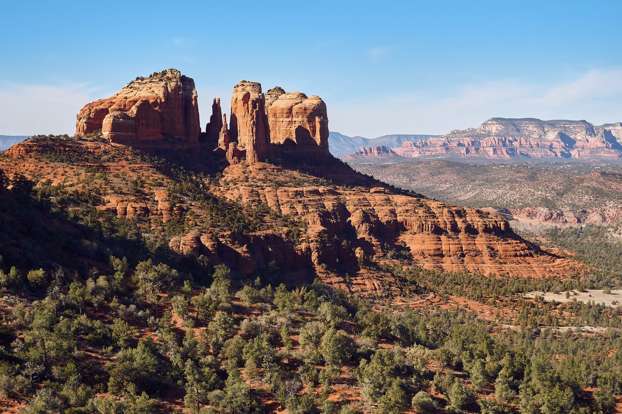
The red sandstone spires of Cathedral Rock rising above a slope of juniper scrub, with pale cliffs on the horizon

The Southwest, United States

Sedona

Cathedral Rock near Sedona, seen from the Cathedral Rock Loop Trail. (Nikolai Gates Vetr / Wikimedia Commons · CC BY-SA 4.0)

A small city in Arizona's northern Verde Valley, set among red sandstone buttes at the mouth of Oak Creek Canyon. Farmers and ranchers settled it in the late 19th century; Hollywood Westerns, artists, retirees and New Age seekers followed. Today it lives on tourism, with hiking and mountain-biking trails, galleries and jeep tours across the surrounding national forest.

Neighbourhoods

  • Uptown Sedona
    • First-time visitors
    • Shopping
    • Close to the canyon

    The original commercial strip along Highway 89A just north of the junction known as the Y, packed with souvenir and craft shops, galleries, restaurants and the offices of the jeep-tour companies. Red cliffs rise directly behind the shopfronts, and Oak Creek Canyon begins just to the north.

    Open in Maps
  • West Sedona
    • Quiet and residential
    • Local life

    The larger part of the city, stretching west along Highway 89A in Yavapai County. Most residents live here, along with supermarkets, everyday restaurants and the high school, and roads lead off to the trailheads of Boynton Canyon and the mesa above the airport.

    Open in Maps
  • Highway 179 and the Gallery District
    • Arts and culture
    • Shopping

    The road south from the Y towards the Chapel of the Holy Cross, lined with galleries and with Tlaquepaque, an arts-and-crafts village of shops and restaurants beside Oak Creek.

    Open in Maps
  • Village of Oak Creek
    • Hiking
    • Quiet and residential

    An unincorporated community about seven miles south of Sedona, outside the city limits but a significant part of the Sedona community. It sits among red-rock buttes, with Bell Rock at its northern edge and a Forest Service visitor centre at its southern end.

    Open in Maps

Things to do

Red rocks and landmarks

  • Chapel of the Holy Crosslandmark

    A Roman Catholic chapel built in 1954–56 into the red buttes south of town, commissioned by the rancher and sculptor Marguerite Brunswig Staude and dominated by a great cross set into its facade.

    Open in Maps
  • Cathedral Rockviewpoint

    A sandstone butte south of the city and one of the most photographed sights in Arizona, reached by a short, steep trail that climbs to the gaps between its spires.

    Open in Maps
  • Bell Rockviewpoint

    A bell-shaped butte at the northern edge of the Village of Oak Creek; a moderate hike reaches a small plateau on its north-west face, while the summit needs a hard, unmarked route.

    Open in Maps
  • Red Rock Crossingviewpoint

    A former ford across Oak Creek, washed out by a flood in 1978, with the classic view of Cathedral Rock reflected in the creek.

    Open in Maps

Parks and the canyon

  • Oak Creek Canyonpark

    The river gorge between Sedona and Flagstaff, often called a smaller cousin of the Grand Canyon, followed by State Route 89A for about 13 miles along its floor.

    Open in Maps
  • Slide Rock State Parkpark

    A state park 7 miles north of town in Oak Creek Canyon, named after a natural water slide on the slippery creek bed and set around a 43-acre working apple farm.

    Open in Maps
  • Red Rock State Parkpark

    A day-use park in a red sandstone canyon five miles south-west of the city, devoted to protecting the streamside habitat along Oak Creek and to environmental education.

    Open in Maps

Arts and galleries

  • Tlaquepaque Arts and Crafts Villageattraction

    A cluster of galleries, shops and restaurants around courtyards beside Oak Creek on Highway 179.

    Open in Maps
  • Sedona Arts Centerattraction

    Founded in 1958 and described as the oldest arts centre in northern Arizona.

    Open in Maps

Short trips from the town

  • Palatki Heritage Siteattraction

    Cliff dwellings and rock art in the national forest west of town; Palatki means 'red house' in the Hopi language.

    Open in Maps
  • Honanki Heritage Siteattraction

    A cliff dwelling and rock art site about 15 miles west of Sedona, home to the Sinagua from about 1100 to 1300 CE.

    Open in Maps
  • Montezuma Castle National Monumentattraction

    A well-preserved cliff dwelling in Camp Verde built by the Southern Sinagua, built as early as 1125 and occupied until as late as 1395.

    Open in Maps
  • Jeromeattraction

    A former copper-mining town on Cleopatra Hill above the Verde Valley that held more than 10,000 people in the 1920s, nearly emptied after the mines closed in 1953 and survived by turning to tourism.

    Open in Maps
  • Verde Canyon Railroadattraction

    A heritage excursion line running 20 miles between Clarkdale and Perkinsville, with its depot and railway museum about 25 miles south-west of Sedona.

    Open in Maps
  • Tuzigoot National Monumentattraction

    A Sinagua pueblo of 110 rooms on a ridge above the Verde River near Clarkdale, built between 1125 and 1400 CE.

    Open in Maps

Seasonal events

  • St Patrick's Day paradeMarch

    One of the town's long list of annual community events.

  • Sedona Solstice FestivalsJune and December

    Summer and winter solstice festivals held at Unity of Sedona.

Eat and drink

Long-standing places and food districts in Sedona. Hours, ratings and directions come from your maps app, always current.

Food districts

  • Tlaquepaque restaurantsneighborhood

    Restaurants and a brewery among the courtyards of the arts-and-crafts village beside Oak Creek.

    Open in Maps
  • Uptown Sedonaneighborhood

    The densest choice of places to eat, many with terraces facing the red cliffs, along the main street north of the Y.

    Open in Maps
  • Hillside Sedonaneighborhood

    A shopping centre on Highway 179 just south of the Y with restaurants and balconies looking over the rocks, including a Mexican-American cantina.

    Open in Maps

Wine

  • Verde Valley wineriesneighborhood

    Arizona's Verde Valley wine appellation, recognised in 2021, covers the basin of the Verde River south-west of Sedona.

    Open in Maps

Experience Sedona

History

The Sinagua people farmed the Verde Valley and built cliff dwellings in the red canyons west of today's town, at Honanki and Palatki, from about 1100 CE; their stone pueblos at Montezuma Castle and Tuzigoot nearby were occupied into the 14th century. The Sinagua are counted among the ancestors of the Hopi, and Palatki's name comes from the Hopi for "red house".

The first European-American settler, John J. Thompson, moved into Oak Creek Canyon in 1876, an area well known for its peach and apple orchards; the early settlers were farmers and ranchers. When a post office opened in 1902 there were 55 residents. The place was named after Sedona Schnebly, wife of the first postmaster; her mother said she made the name up because it sounded pretty. Electricity reached some parts only in the 1960s, and the area, split between Coconino and Yavapai counties, had no local government at all.

Hollywood came first: from 1923 into the 1970s more than sixty productions were filmed among the rocks, usually standing in for Texas or California. From the 1950s Sedona grew as a tourist, holiday-home and retirement town; the Chapel of the Holy Cross was completed in 1956, and the surrealist Max Ernst drew attention from the art world when the town still had fewer than a hundred people. In 1987 José Argüelles organised the "Harmonic Convergence" there, and the town now has a New Age tourist industry. Most of today's town was built in the 1980s and 1990s, and Sedona was incorporated as a city in 1988. Wildfires burned in the surrounding forest in 2006 and 2014.

Culture & Customs

Sedona's identity is bound up with its setting. The rocks are made of the Schnebly Hill Formation, a pink Permian sandstone found only around Sedona, and they seem to glow at sunrise and sunset. In 1993 the city even refused to let McDonald's use its yellow arches, which it feared would clash with the scenery, and the restaurant uses a blue logo instead.

The town is an arts community. The Sedona Arts Center, founded in 1958, is the oldest in northern Arizona, there is a chamber music programme, and galleries line Highway 179 and Uptown. The Sedona International Film Festival, an eight-day event, has been held since the mid-1990s, and the town's role in film history is part of its story. The calendar also includes a St Patrick's Day parade, a marathon, food-truck and hummingbird festivals and solstice gatherings.

Sedona is also known for spiritual tourism. Some New Age believers hold that "spiritual vortices" are concentrated at Bell Rock, Airport Mesa, Cathedral Rock and Boynton Canyon, and many shops offer crystals, aura readings and vortex information. These are matters of belief rather than science, and the town's visitors range from hikers and mountain bikers to people on retreat. Shops also sell Native American arts and crafts from across the region.

Daily Life

About 9,700 people lived in the city at the 2020 census, with several thousand more in the Village of Oak Creek to the south. It is an old town in a demographic sense: the median age was 62.6, and more than two in five residents were 65 or over. A quarter of homes were counted as vacant, a sign of how many are second homes and holiday rentals. The city straddles two counties — Uptown, the gallery district and the chapel area in Coconino, West Sedona in Yavapai.

Tourism, retirement and second homes drive the economy. Hotels, restaurants, galleries, spas and tour companies provide much of the work. Hospital care is based in Cottonwood, with an outpatient campus and emergency services in Sedona.

The city lies within the Coconino National Forest, and by 2007 there was no large tract of undeveloped land left. Traffic on the two highways and crowding at the most popular trailheads are everyday concerns in the busy seasons. The rhythm of the day follows the light: trailheads fill at dawn, and crowds gather at viewpoints for the sunset.

Food

Sedona has no cuisine of its own, but it eats as northern Arizona does, with Mexican and Southwestern cooking prominent: enchiladas, tamales and dishes flavoured with chile, alongside the steakhouses and modern American restaurants that cater to visitors. Many restaurants are chosen as much for their terraces facing the red cliffs as for their menus, and the Tlaquepaque courtyards, Hillside and Uptown hold most of them.

Farming history survives in a small way. Oak Creek Canyon was well known for its peach and apple orchards, and Slide Rock State Park still includes a working apple farm.

Wine has become the area's newest food story. The Verde Valley south-west of town was recognised as an American Viticultural Area in 2021, with vineyards in the basin of the Verde River supplying the area's wineries. Craft beer is brewed in town too, at a brewery and grill among the Tlaquepaque courtyards. Like the rest of the town's trade, its restaurants depend heavily on visitors, and most of them stand along the two highways.

Planning tools

Budget

Sedona is one of the dearer places to stay in the Southwest: rooms are limited, demand is high and prices rise at weekends and in spring and autumn. Much of the best of the area costs little — trails, viewpoints and the chapel — but trailhead parking needs a Red Rock Pass, and jeep tours, state parks and spa treatments add up.

Daily Budget Midrange
USD 230–420 (mid-range hotel, sit-down dinners, a jeep tour, park fees and a hire car)
Daily Budget Shoestring
USD 100–170 (campground or motel in a nearby town, self-catering and casual Mexican food, own car)

Buy a Red Rock Pass before parking at trailheads, and start hikes early, when the car parks still have space.

Best Time to Visit

Spring and autumn are the main seasons, with warm days and cool nights that suit hiking. Summer is hot, with July afternoons averaging close to 97°F, and the monsoon brings thunderstorms from roughly July to September. Winter is mild by day and near freezing at night.

Suggested Number of Days

Two or three days cover the town, a few trails and the main viewpoints. Four or five allow time for the cliff dwellings and old mining towns of the Verde Valley and the drive up the canyon. Keen hikers and mountain bikers often stay longer.

First Visit
2–3 days
With Surroundings
4–5 days

Transportation

A car is the practical way to get around: the city is spread out along two highways, and a bike or car is needed to reach most trailheads. Traffic is heavy at the junction known as the Y and along Highway 179 at busy times. Jeep and trolley tours are a common way to see the rocks without driving rough forest roads, and many people hike or ride mountain bikes on the trail network.

Display a Red Rock Pass when parking at trailheads, and allow extra time for traffic at the Y in busy seasons.

Airport & Station Connections

Most visitors fly into Phoenix Sky Harbor International Airport, 119 miles away, and drive north on Interstate 17. Flagstaff Pulliam Airport, 26 miles away, has a few regional flights, and Prescott Regional Airport is 68 miles away. Sedona's own airport, on a mesa above the city, handles only general aviation.

Walkability

Uptown and the Tlaquepaque area can each be explored on foot, and a walk between them is possible, but the rest of the city is spread along busy highways with long gaps between places. Trailheads are scattered around the edges of town and are normally reached by car.

Safety

For most visitors the US is safe, with the main risks being petty theft and car break-ins in tourist areas of some cities, road accidents over long distances, extreme weather, and the hazards of the outdoors. In Sedona the main dangers are on the trails: summer heat, steep slickrock and getting lost on the many crossing paths. Monsoon storms can turn dry washes into floods, and the area has seen large wildfires, in 2006 and 2014.

Carry plenty of water, hike early in summer, stay off exposed rock in thunderstorms, and leave nothing visible in cars at trailheads. Check current official travel advice before travelling.

Climate

A high-desert, semi-arid climate with mild winters and hot summers. Annual rainfall is just over 17 inches, much of it from winter storms and the summer monsoon.

Summer
hot and sunny — July averages a high of about 97°F and a low of about 68°F, with afternoon storms in the monsoon
Winter
mild days and cold nights — January averages a high of about 58°F and a low of about 34°F

Local Customs

Tipping is expected: roughly 18–22 per cent in restaurants. The town is casual in dress. Many visitors come for spiritual reasons — some New Age believers hold that energy 'vortices' are concentrated at sites such as Bell Rock, Airport Mesa, Cathedral Rock and Boynton Canyon — and meditation or ceremonies at these places are best left undisturbed. The chapel is a working place of worship.

Identification is asked for when buying alcohol (the legal age is 21). Stay on marked trails and do not touch rock art or walls at the cliff-dwelling sites.

Common Payment Methods

The currency is the US dollar. Cards and contactless payment are accepted almost everywhere, including by tour operators; a little cash is useful for tips, and ATMs are easy to find.