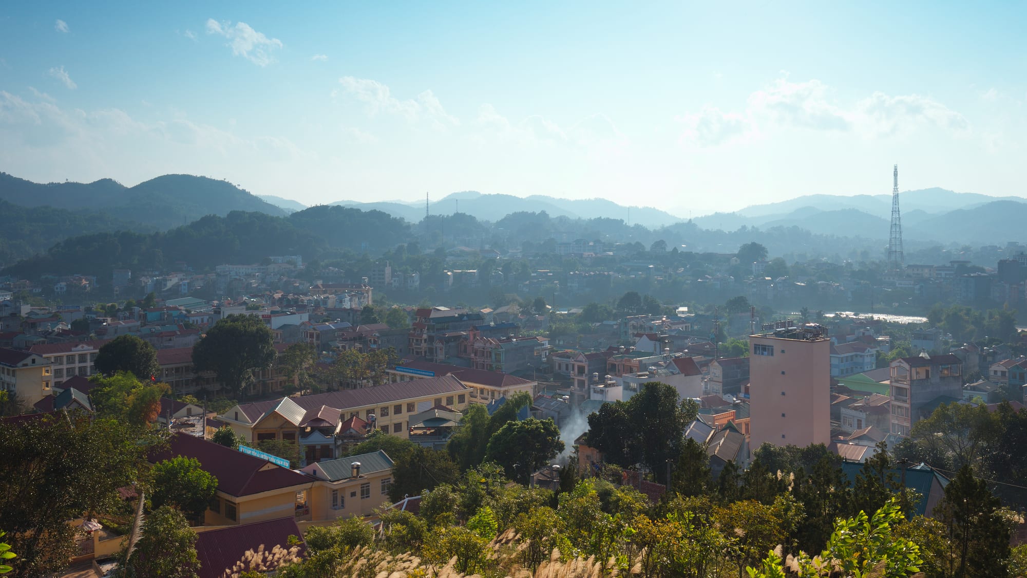
A small town of red and orange roofs spread along a valley floor with wooded hills and blue ridges fading behind it

Hanoi & the North, Vietnam

Cao Bang

Cao Bang seen from the hills above the town, with the mountains of the Chinese border country beyond. (Tycho / Wikimedia Commons · CC BY-SA 3.0)

A small provincial capital in Vietnam's far north-east, set where the Bằng and Hiến rivers meet among limestone hills close to the Chinese border. Fought over in the wars of the twentieth century and rebuilt afterwards, it is a market and administrative town of riverside streets that serves as the base for the Bản Giốc waterfall, the border caves and the surrounding geopark.

Neighbourhoods

  • The riverside centre
    • First-time visitors
    • Restaurants
    • Evening walks

    The blocks along the Bằng River where the hotels, banks, offices and most restaurants stand. A walkway and a small park follow the water, and the bridges linking the two halves of the town are the busiest points in the evening.

    Open in Maps
  • The market quarter
    • Best for food
    • Local life
    • Shopping

    The streets around the town's covered market, north-east of the river bend, where produce from the surrounding districts, dried goods and cheap Chinese imports are sold. Noodle stalls, hardware shops and motorbike repairers fill the surrounding lanes, and trade is over well before the afternoon.

    Open in Maps
  • The old citadel hill
    • Historic district
    • Quiet and residential
    • Views

    The high ground above the confluence, where the earthworks and remains of the town's fortifications overlook both rivers. The slopes below carry older houses, a pagoda and steps down to the water, and the hilltop gives the clearest view of how the town sits in its valley.

    Open in Maps
  • The outskirts and the bus station
    • Arrivals and departures
    • Close to public transport

    The approaches along the roads to Hanoi and to the border districts, where the bus station, workshops, warehouses and newer housing spread out along the valley. Guesthouses here are cheaper, though a long walk from the river.

    Open in Maps

Things to do

In and above the town

  • Bằng Riverattraction

    The river that runs through the middle of the town, crossed by bridges and followed by a riverside walk, joining the Hiến below the old citadel hill.

    Open in Maps
  • Cao Bằng marketmarket

    The town's main covered market, supplied by growers from the surrounding valleys and by trade across the nearby border.

    Open in Maps

The geopark and the caves

  • Non Nước Cao Bằng Geoparkpark

    A UNESCO Global Geopark covering much of the province's limestone country, with marked routes linking caves, waterfalls, lakes and fossil sites.

    Open in Maps
  • Ngườm Ngao Caveattraction

    A limestone cave in Trùng Khánh, a few kilometres from the Bản Giốc waterfall, running some two kilometres past stalactite and stalagmite formations and open to visitors since the 1990s.

    Open in Maps
  • Thang Hen mountain lakesattraction

    A cluster of around thirty-six small lakes in the limestone country of Trà Lĩnh, north-east of the town, set at about 1,000 metres among karst peaks.

    Open in Maps
  • Mắt Thần Mountainattraction

    The "Eye of God" peak in Trà Lĩnh, a limestone hill pierced by a large natural hole, one of the best-known stops in the geopark.

    Open in Maps

Short trips from the town

  • Bản Giốc Waterfallattraction

    A wide, terraced waterfall on the Quây Sơn River astride the border with China, and the reason most visitors come to the province.

    Open in Maps
  • Pác Bólandmark

    The village and cave about 3 km from the Chinese border where Hồ Chí Minh lived for several weeks in 1941 after three decades abroad, and where the Việt Minh was founded; it is now a memorial site.

    Open in Maps
  • Lạng Sơnattraction

    The border city south-east of Cao Bang, known for its markets, caves and the Hữu Nghị crossing into China.

    Open in Maps

Seasonal events

  • TếtJanuary or February

    The lunar new year, when families return to the villages, markets empty for several days and pagodas fill with visitors.

  • Lồng tồng, the Tày and Nùng field festivalthe first lunar month, February or March

    Villages around the town hold their going-to-the-field festival after Tết, with offerings for a good harvest, folk singing and games of còn, a thrown cloth ball.

  • The buckwheat and autumn harvest seasonSeptember to November

    The valleys turn gold before the rice harvest and the upland districts are at their busiest, the most popular months for riding the border roads.

Eat and drink

Long-standing places and food districts in Cao Bang. Hours, ratings and directions come from your maps app, always current.

Cao Bang classics

  • Phở chua stalls in the centreneighborhood

    A north-eastern speciality most closely associated with neighbouring Lạng Sơn and eaten across the border provinces — rice noodles served cool with roast pork, liver, peanuts and herbs in a sweet-sour dressing.

    Open in Maps
  • Bánh cuốn canh kitchensneighborhood

    Steamed rice rolls, a northern staple, are served here in a bowl of hot broth rather than with a dipping sauce, and are eaten for breakfast across the town.

    Open in Maps

Markets and street food

  • Cao Bằng marketmarket

    The morning market for river fish, mountain vegetables, chestnuts and dried buffalo meat, with noodle and sticky-rice stalls among the produce.

    Open in Maps
  • The riverside cafésneighborhood

    Cafés along the water serve strong Vietnamese coffee with condensed milk and, in the evening, beer and grilled skewers at pavement tables.

    Open in Maps

Experience Cao Bang

History

Cao Bang's valley has been a frontier for as long as there has been a Vietnamese state, a corridor of limestone and river gaps between the Red River Delta and what is now Guangxi. Tày and Nùng communities farmed it, and local records place an early Tày polity in this country before Chinese and Vietnamese administration reached it. In the 16th and 17th centuries the Mạc dynasty, driven from Thăng Long, held out here for decades, ruling from fortifications above the confluence of the Bằng and the Hiến; the remains on the citadel hill above the town date from that long rearguard.

The French took the region in the 1880s and built a road up from Lạng Sơn and a garrison town of colonial offices and barracks on the river. Its remoteness made it useful to the Vietnamese independence movement: Hồ Chí Minh crossed from China into the province in 1941 and based himself at Pác Bó, where the Việt Minh was founded; the first units of what became the Vietnamese army were formed in December 1944. In 1950 a border campaign drove French forces out of the town, an early turning point in the war.

Peace was brief. In February 1979 Chinese troops crossed the border in force and the town was among those largely destroyed before the withdrawal, leaving little of its older built fabric. Cao Bang was rebuilt through the 1980s and 1990s in plain concrete, and the town became a city in 2012. The reopening of border trade, the UNESCO geopark designation and improving roads from Hanoi have since turned a remote administrative town into the base for the province's tourism.

Culture & Customs

This is a minority province rather than a Kinh one, and the town reflects it. Tày and Nùng people form the great majority in the surrounding districts, with Hmong, Dao, Lô Lô and Sán Chay communities in the higher valleys, and it is normal to hear Tày spoken in the market alongside Vietnamese. Stilt houses with earth walls and yin-yang tiled roofs stand in the villages just outside the built-up area, and village halls and spirit shrines still order the farming year.

Music and ritual survive strongly here. Then singing, accompanied by the gourd lute and practised by Tày, Nùng and Thái communities across the northern border provinces, was inscribed by UNESCO as intangible cultural heritage in 2019, and is performed at ceremonies and festivals rather than as a show. After Tết, villages hold the lồng tồng going-to-the-field festival, with offerings, folk songs and the game of còn, in which a cloth ball is thrown through a ring on a high pole. Craft villages in the surrounding districts keep up blacksmithing, paper-making and other handwork.

The memory of war shapes public life more than in most Vietnamese towns. Pác Bó and the town's war memorials are visited by school groups and by veterans, and the events of 1979 are part of family history for most older residents. People are used to the border: goods, relatives and language cross it, and pragmatism about China coexists with a long historical wariness.

Daily Life

The town counted about 74,000 people at the 2019 census, in a province of roughly half a million, and Cao Bang is small enough that much of it knows itself. Administration is the biggest employer — provincial offices, schools, the hospital, the army and border guard — alongside trade, transport and services for the surrounding districts. Farming continues right up to the edge of the built-up area, with rice and maize in the valley floors and chestnut, star anise and forestry on the slopes.

Money comes into the province from cross-border trade at the district crossings, from remittances sent by young people working in Hanoi, Bắc Ninh or abroad, and increasingly from visitors to the waterfall and the geopark. It remains one of the poorer provinces of Vietnam, and rural roads, water supply and schools show it, though better roads towards Hanoi are slowly shortening the journey down to the delta.

The day is early: the market is at its fullest between six and eight in the morning, offices open before eight, and lunch is followed by a real pause in the heat. Evenings belong to the riverbank, where families walk, teenagers gather on motorbikes and cafés and beer tables spill onto the pavement. Weekly and periodic markets in the surrounding district towns draw people down from the hills and are as much social occasions as trade.

Food

The north-east's best-known noodle dish is phở chua, sour phở: rice noodles served cool and dressed rather than in broth, topped with roast pork belly, fried liver, sweet potato crisps, peanuts, herbs and a sweet-and-sour sauce. It is eaten as a light meal at any time of day and is associated above all with neighbouring Lạng Sơn, though it is sold here too; duck phở, phở vịt, is a speciality of Cao Bằng and Lạng Sơn alike. The local version of bánh cuốn is the other distinctive dish — steamed rice rolls filled with pork and mushroom, served in a bowl of hot bone broth with a rib in it, and eaten with a spoon at breakfast.

Upland ingredients run through everything else. Dried and smoked buffalo meat comes down from the hills, khâu nhục — a braised pork belly dish the Tày and Nùng adopted from China — is served at feasts, and xôi trám is sticky rice cooked with the dark, oily trám fruit, a speciality of the province. Chestnuts from Trùng Khánh, small, sweet and roasted at roadside braziers in autumn, are the thing people take home, along with bánh khảo, a dry pressed cake of rice flour and sugar made for Tết. Freshwater fish from the Quây Sơn and the Bằng are grilled or soured into soups.

To drink there is corn spirit distilled in the villages, poured freely at homestays and celebrations, along with weak draught beer and coffee taken very sweet. Thạch đen, a black grass jelly served cold with sugar syrup, is the standard hot-weather refreshment.

Planning tools

Budget

Cao Bang is one of the cheaper provincial towns in Vietnam, with simple hotels and guesthouses and low food prices. The main expense is transport: the sights are spread across the province, and most visitors pay for a car and driver, a motorbike hire or a place on a tour to reach the waterfall and the border districts.

Daily Budget Midrange
USD 60–130 (best hotel in town or a homestay near the falls, restaurant meals, a car and driver for the day)
Daily Budget Shoestring
USD 20–35 (guesthouse or homestay, market food, shared transport or a rented motorbike)

Carry cash for homestays, entrance fees and rural stops, and agree a driver's route and price before setting out.

Best Time to Visit

September to November is the classic season, with dry, clear days, the harvest in the valleys and the waterfall still full after the summer rain. March to May is mild and green. Summer brings heavy downpours and the risk of landslides and flash floods on the mountain roads, while December and January can be cold and misty, with the falls at their lowest.

Suggested Number of Days

A night or two is usually enough for the town itself and one trip out. Three or four days allow the waterfall, the border caves and the geopark roads at a reasonable pace, and riders continuing towards Ha Giang or Ba Bể should add more.

First Visit
1–2 days
With Surroundings
3–4 days

Transportation

The town is small enough to cross on foot, and motorbike taxis and a handful of metered taxis cover the rest. Beyond it there is no useful public transport for visitors: local buses serve the district towns infrequently, so most people hire a motorbike, a car with a driver or join a tour. Roads to the waterfall and the border villages are paved but winding, and mountain sections can be blocked after heavy rain.

Fill up with fuel in the town before heading into the border districts, where petrol stations are widely spaced.

Airport & Station Connections

There is no airport or railway. The town is reached by road from Hanoi, about 270 km away, with sleeper and day buses taking roughly six to eight hours depending on the route; buses also run from Lạng Sơn, Thái Nguyên and Bắc Kạn. Many travellers arrive by motorbike on the loop from Ha Giang or Ba Bể.

Walkability

The centre is compact and flat along the river, and the market, hotels and restaurants are within about fifteen minutes of each other on foot. The town spreads up the valley sides, so outlying districts involve steep climbs, and pavements are often occupied by parked motorbikes. Traffic is light by Vietnamese standards, which makes walking easier than in the cities.

Safety

Cao Bang is a quiet town with very little crime affecting visitors. The real hazards are on the roads — steep bends, lorries, and rain-slick or landslip-prone surfaces in the mountains — along with fast water at the waterfalls and caves. The Chinese border runs close to several sights, so marked areas and checkpoints should be respected and crossings made only at official gates.

Only ride a motorbike if experienced and licensed, and always with a helmet; hold bags away from the road; and drink bottled or filtered water. Check current official travel advice before travelling.

Climate

A humid subtropical mountain climate, cooler than the delta because of the altitude. Most rain falls between May and September, often heavily enough to cause landslides, and winter brings cold, damp, misty spells with occasional frost on the higher ground.

Summer
warm to hot and wet, typically 25–33°C, with thunderstorms and heavy rain
Winter
cold and damp for northern Vietnam, often 10–18°C, colder at night in the hills

Local Customs

The province is largely Tày, Nùng, Hmong and Dao, and village life is conservative and hospitable in equal measure. Guests at a homestay take their shoes off, wait to be shown where to sit and are offered rice wine that is hard to refuse politely. Modest dress is expected at pagodas and at memorial sites such as Pác Bó, where behaviour is respectful rather than casual. Tipping is not expected.

Ask before photographing people at markets or in villages, especially in ethnic minority dress, and follow signs and soldiers' directions near the border.

Common Payment Methods

The currency is the Vietnamese đồng. Hotels and larger restaurants in the town accept cards and QR-code payments, but markets, homestays, entrance gates and rural stops are cash only. There are ATMs in the centre and few outside it, so money is best drawn before leaving the town.