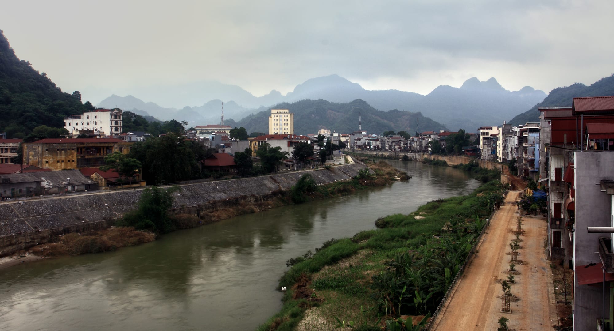
A small town of low buildings along both banks of a wide brown river, with layered limestone ridges disappearing into mist behind

Hanoi & the North, Vietnam

Ha Giang

Ha Giang on the Lô River, with the limestone ridges of the far north behind. (Idan Robbins / Wikimedia Commons · CC BY-SA 4.0)

A small upland town on the Lô River in Vietnam's far north, ringed by forested limestone hills close to the Chinese border. It is the administrative and market centre of the Hà Giang uplands and the place where the mountain circuit known as the Ha Giang loop begins and ends, so most visitors treat it as a base rather than a destination.

Neighbourhoods

  • The riverfront and town centre
    • First-time visitors
    • Close to transport
    • Best for food

    A few streets of shops, offices and hotels along the east bank of the Lô, with the market, the bus station and most of the hostels and motorbike rental offices within walking distance. This is where loop riders gather, eat and arrange their transport.

    Open in Maps
  • The west bank
    • Quiet and residential
    • Views

    Across the bridges, a quieter grid of houses, schools and small guesthouses beneath the hills, with a riverside path and views back over the town.

    Open in Maps
  • Hạ Thành and the valley villages
    • Homestays
    • Walking
    • Local life

    Tày villages of stilt houses and rice terraces a few kilometres out of town, where homestays offer a first, easy taste of upland life for anyone not riding the whole circuit.

    Open in Maps
  • The road north
    • Departures
    • Views

    The start of Route 4C climbing out of the valley towards Quản Bạ, lined with fuel stations, repair shops and viewpoints; guesthouses along it suit riders leaving early.

    Open in Maps

Things to do

In and around the town

  • Lô Riverlandmark

    The river that rises in Yunnan and runs through the town on its way to the Red River, with embankments, bridges and an evening walking route.

    Open in Maps
  • Hạ Thành villageneighborhood

    A Tày village of wooden stilt houses and terraces at the edge of town, a short ride out for a walk and a meal with a family.

    Open in Maps
  • Ha Giang marketmarket

    The town's daily market, where upland families bring maize, greens, herbs, honey and livestock down from the hills.

    Open in Maps

Short trips on the southern loop

  • Quản Bạviewpoint

    The first pass on the road north, where a gateway of hills above the district town of Tam Sơn looks down on the twin conical mounds known as the fairy bosom.

    Open in Maps
  • Yên Minhattraction

    A valley town among pine plantations roughly halfway to the plateau, the usual first overnight stop on the circuit.

    Open in Maps
  • Hoàng Su Phìviewpoint

    A district of very steep terraces west of the town, worked by Dao, Nùng and La Chí communities and at its most striking before the September harvest.

    Open in Maps
  • Du Giàattraction

    A village and waterfall on the quieter eastern arm of the circuit, popular for homestays among rice fields.

    Open in Maps

Short trips to the Đồng Văn plateau

  • Đồng Văn Karst Plateau Geoparklandmark

    A UNESCO Global Geopark since 2010, covering the grey limestone plateau of the far north across four upland districts, where maize is grown in pockets of soil between the rocks.

    Open in Maps
  • Mã Pí Lèng Passviewpoint

    The most dramatic section of the circuit, part of the Happiness Road built between 1959 and 1965, largely by hand, along a cliff high above the Nho Quế gorge.

    Open in Maps
  • Nho Quế Riverlandmark

    A narrow green river far below the pass, running through the Tu Sản canyon and travelled by small boats from a landing reached by a steep side road.

    Open in Maps
  • Lũng Cú Flag Towerlandmark

    A tower on a hill near the northernmost point of Vietnam, flying a very large national flag above villages within sight of China.

    Open in Maps
  • Vương family mansionlandmark

    The walled stone and timber residence built at Sà Phìn in 1902 and 1903 for the Hmong family that governed the plateau under French authority, set in a valley of stone walls.

    Open in Maps
  • Đồng Vănattraction

    The plateau's main town, a few kilometres from the Chinese border, with an old quarter of clay and stone houses around an old market building and a Sunday morning trading day.

    Open in Maps
  • Mèo Vạcattraction

    The town at the far end of the Mã Pí Lèng pass, whose Sunday market draws Hmong, Lô Lô and Giáy families down from the surrounding communes.

    Open in Maps

Seasonal events

  • Tết Nguyên ĐánJanuary or February

    The lunar new year, when villages hold their own ceremonies, markets pause and transport across the uplands becomes difficult for several days.

  • Khâu Vai love marketthe 27th day of the third lunar month, usually April or May

    An annual gathering near Mèo Vạc, traditionally a night when former sweethearts could meet again, now a large festival of music, trade and crowds.

  • Buckwheat flower seasonOctober and November

    The plateau's fields turn pink and white as the buckwheat flowers, the busiest weeks of the year for Vietnamese visitors and the subject of a provincial festival.

  • Sunday marketsall year, Sunday mornings

    Đồng Văn, Mèo Vạc and other upland towns hold their weekly markets at first light, with livestock, cloth, corn wine and cauldrons of stew.

Eat and drink

Long-standing places and food districts in Ha Giang. Hours, ratings and directions come from your maps app, always current.

Upland dishes

  • Cháo ấu tẩu stallsrestaurant

    A dark, bitter rice porridge made with a tuber that must be simmered for hours to be safe, eaten late at night in the cold and regarded as the town's own dish.

    Open in Maps
  • Thắng dền and evening snack stallsrestaurant

    Small glutinous rice balls in hot ginger syrup with coconut and peanut, sold from pavement stalls after dark along with grilled skewers and sweetcorn.

    Open in Maps
  • Hmong and Tày kitchensrestaurant

    Family restaurants serving mèn mén, steamed maize meal, with pork, buffalo dried over the hearth, bamboo shoots and mountain greens.

    Open in Maps

Markets and food streets

  • Ha Giang marketmarket

    Morning trade in produce brought down from the hills, including mint honey from the plateau, Shan tuyết tea and jars of corn spirit.

    Open in Maps
  • The riverfront restaurant streetsneighborhood

    Hotpot houses, noodle shops and beer tables along the central streets, where riders eat before and after the circuit.

    Open in Maps
  • Upland weekly marketsmarket

    The Sunday markets on the plateau, where thắng cố is ladled from cauldrons and corn wine is poured from plastic cans — as much a social event as a place to shop.

    Open in Maps

Experience Ha Giang

History

The valley of the Lô was on the edge of Vietnamese authority for most of its history. Its peoples — Hmong, Dao, Tày, Nùng, Giáy, Lô Lô and others — arrived in successive migrations from the north over several centuries, and the high karst country was governed in practice by local lords rather than by the court. The French, who occupied the region in 1886, built a garrison on the east bank of the Lô and ruled the plateau indirectly, recognising the Hmong lord Vương Chính Đức as king of the Hmong in 1900 and leaving his family in authority over Đồng Văn and Mèo Vạc. Their walled mansion, built at Sà Phìn in 1902 and 1903, still stands.

After 1945 the new state extended direct administration into the uplands, and between 1959 and 1965 youth volunteers and local labourers cut the road now called the Happiness Road along the cliffs of Mã Pí Lèng, largely by hand, connecting Đồng Văn and Mèo Vạc to the rest of the country for the first time. It remains the defining engineering work of the region.

In February 1979 Chinese forces crossed the border some twenty-five kilometres north, and the town was heavily damaged before being rebuilt; fighting along this frontier went on at intervals until 1989, longest and most severely at Vị Xuyên south of the town, where a war cemetery records the dead. The border was normalised in the 1990s. Tourism arrived only in the 2010s, after restrictions on travel in the frontier zone eased and the plateau was recognised as a UNESCO Global Geopark, and the loop has since become one of the best-known journeys in Vietnam. In June 2025 Hà Giang province was incorporated into Tuyên Quang province, though the name stays on the uplands and on the circuit.

Culture & Customs

The uplands around Ha Giang are among the most ethnically varied parts of Vietnam, and the town is where those communities meet. Hmong groups are the most numerous on the plateau, recognisable by embroidered and pleated dress that differs from valley to valley; Dao women wear red headcloths and silver; Lô Lô villages near Lũng Cú keep bronze drums used at funerals; Tày and Nùng farm the lower valleys from stilt houses.

The weekly market is the central institution. Families walk or ride for hours to Đồng Văn or Mèo Vạc on a Sunday to trade buffalo, pigs, cloth and herbs, meet relatives, eat thắng cố from the cauldron and drink corn wine; the trading is only part of the reason for going. The Khâu Vai gathering each spring, once a night when former lovers married to others were permitted to meet, has become the best-known of these occasions.

Music and craft are household matters here rather than staged ones: the Hmong reed pipe played at funerals, flax grown, woven and dyed in indigo, beeswax batik, silver worked in village forges. Visitors are welcomed with drink and directness, and the etiquette that matters most is around the house altar, the main door and the acceptance of hospitality. Tourism has brought income and, with it, a familiar argument about how much of this should be performed.

Daily Life

About 55,000 people live in the city, a small, low-built place strung along both banks of the Lô. It functions as the service centre for a far larger rural population: offices, hospitals, boarding schools for children from distant communes, a bus station and the market where upland produce is sold on.

Beyond the town, life is farming on very difficult ground. Maize rather than rice is the staple crop of the plateau, planted in pockets of soil between the rocks and carried out in baskets; rice terraces are worked in the lower valleys, alongside cardamom, tea, cattle and the mint-flower honey the plateau is known for. Water is the constant problem on the karst, where villages depend on rainfall collected in tanks through a long dry winter.

Incomes are among the lowest in Vietnam, and many working-age adults migrate to factories in the delta or across the Chinese border for part of the year. Tourism has changed the town itself considerably since the late 2010s, adding hostels, rental garages, tour offices and cafés along the riverfront, and it has brought homestay income to villages along the loop. Road maintenance, landslides, schooling and the loss of young people to the lowlands are the recurring local concerns.

Food

Ha Giang eats what the mountains produce. Mèn mén, maize ground and steamed into a dry crumb, is the traditional staple of Hmong households, served with soup, greens and pork. Thịt trâu gác bếp — buffalo rubbed with mắc khén pepper and hung above the hearth until it is dark and hard — is the region's best-known product, and thắng cố, the long-simmered stew of horse or buffalo meat and offal, belongs to market day and to the company that goes with it.

The town has two specialities of its own. Cháo ấu tẩu is a dark, bitter porridge made with a mountain tuber that is poisonous unless cooked for many hours, eaten at night as a remedy for cold and aching limbs. Thắng dền, small glutinous rice balls in hot ginger syrup with coconut and crushed peanut, is the sweet eaten at the same hour. Bánh cuốn from Đồng Văn is served unusually with a bowl of bone broth rather than dipping sauce, often with an egg steamed into the roll.

Drinks and preserves round it out: rượu ngô, the corn spirit distilled in the villages, Shan tuyết tea picked from old trees on the high slopes, and bạc hà honey gathered from buckwheat and mint flowers in autumn. Most of these appear in the town market in jars and plastic cans rather than in shops.

Planning tools

Budget

Ha Giang is one of the cheapest places in Vietnam to stay and eat, and the cost of a visit is really the cost of the circuit: a motorbike, or a seat behind a local rider, plus fuel, homestays and meals over three or four days. Group tours bundle all of it. Prices climb during the buckwheat weeks and Vietnamese holidays, when beds on the plateau are scarce.

Daily Budget Midrange
USD 60–130 (hotel or better homestay, restaurant meals, a local rider or a car with driver, boat and site fees)
Daily Budget Shoestring
USD 20–35 (hostel or homestay, market and street food, shared transport, self-driven motorbike)

Carry enough cash for the whole circuit, as machines and card acceptance are limited outside the town, and expect homestays to be paid in cash.

Best Time to Visit

October and November are the classic months, with dry air, clear passes and buckwheat in flower. March and April bring plum and pear blossom and mild weather. Summer is wet, with landslides and washed-out sections on the mountain roads, and winter is cold, foggy and sometimes icy on the highest ground, which makes riding difficult.

Suggested Number of Days

The circuit takes three or four days at a reasonable pace, plus the journey from Hanoi at each end. Five or six allow the western terraces or the quieter eastern roads as well, and weather can cost a day at any time of year.

First Visit
3–4 days
With Surroundings
5–6 days

Transportation

The town is small enough to walk, and everything else is done on the mountain roads. Most visitors ride the loop over three or four days, many on the back of a local driver's motorbike, and cars with drivers and small group tours are also available. Roads are paved but narrow, steep and full of blind bends, with lorries, livestock and landslide debris. Buses connect the town with Hanoi and with the district towns.

Hire a local rider unless experienced on mountain roads, check that any rental insurance and licence arrangement is genuine, and never ride the passes in rain, fog or after dark.

Airport & Station Connections

Ha Giang is reached from Hanoi by sleeper bus or limousine minibus, a journey of roughly six to eight hours depending on the road and the operator, with most services arriving early in the morning. There is no airport and no railway; the nearest flights are at Hanoi's Nội Bài. Roads also run west from Lào Cai and east towards Cao Bằng, both slow mountain routes.

Walkability

The centre is compact and flat along the river, and the market, bus station, hostels and restaurants are all within a short walk of each other. Beyond the town there is no walking network: the roads climb immediately, carry fast traffic and have no pavement, and the valley villages are a ride rather than a stroll.

Safety

The main danger is the road. Motorbike crashes on the loop are the most common serious incident involving foreign visitors, caused by inexperience, loose gravel, wet surfaces and blind bends above long drops. Landslides close sections in the rainy season, fog cuts visibility on the passes, and medical facilities in the uplands are basic. Crime against visitors is rare.

Wear a proper helmet and covered clothing, ride slowly and within experience, and stop when the weather closes in. Only ride a motorbike if experienced and licensed, and always with a helmet; hold bags away from the road; drink bottled or filtered water; and check surf conditions before swimming. Check current official travel advice before travelling.

Climate

A humid subtropical climate strongly modified by altitude, with the town in a warm valley and the plateau much colder. Rain falls mainly between May and September and can be torrential, and fog is common in the cool months from November to March.

Summer
hot and very wet in the valley, usually 25–33°C, cooler on the plateau, with heavy rain and landslides
Winter
cool and foggy, about 10–18°C in the town and near freezing at night on the high ground

Local Customs

Most people in the surrounding districts belong to Hmong, Dao, Tày, Nùng, Giáy or Lô Lô communities, each with its own language and dress. Households have their own rules about altars, doorways and where guests may sit, and a homestay host will explain what matters. Offers of corn wine are a form of welcome; a small sip and thanks are enough if drinking is unwanted.

Ask before photographing people, particularly at markets and in traditional dress, do not photograph border posts or military positions, and do not give money or sweets to children along the roads.

Common Payment Methods

The currency is the Vietnamese đồng. ATMs and card payment exist in the town, and are far less reliable in the district towns; homestays, market stalls, fuel pumps and riders generally want cash. It is normal to change money and draw cash in Ha Giang before starting the circuit.