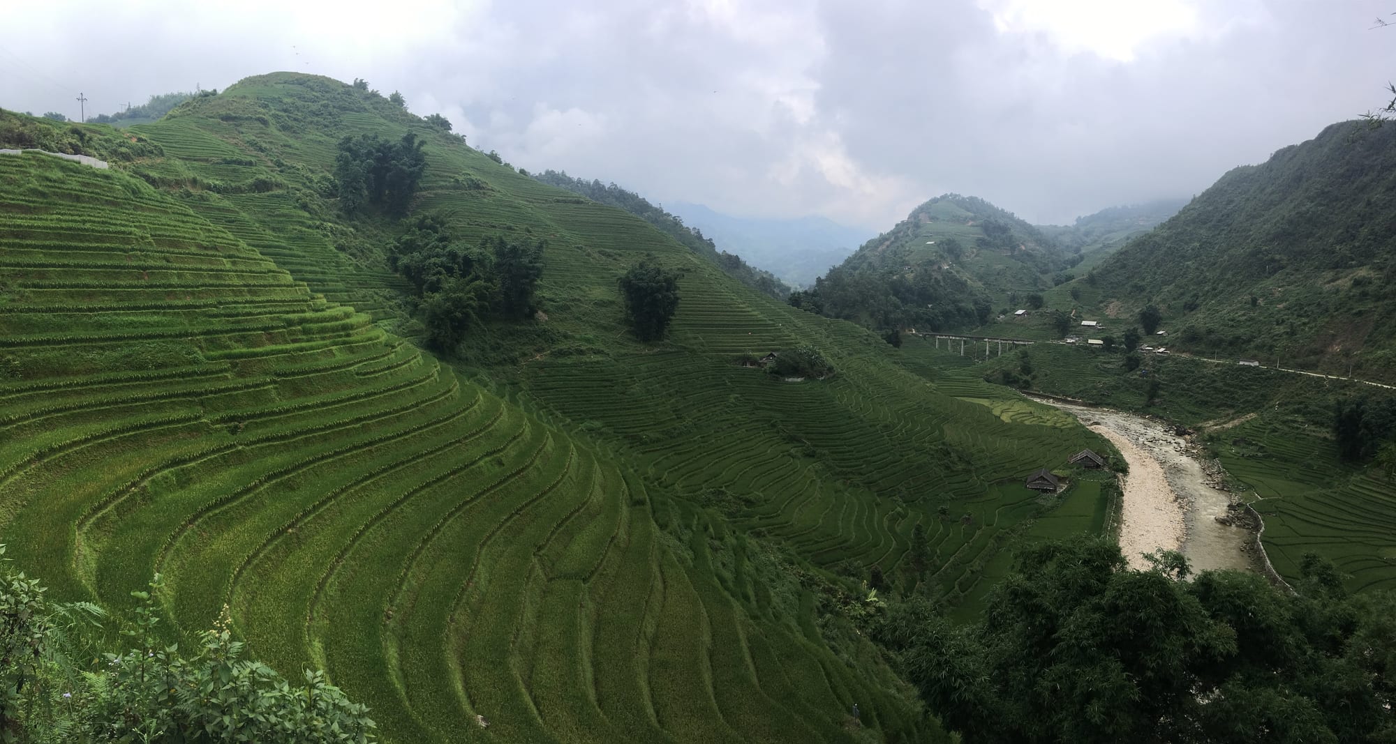
Green rice terraces curving down steep hillsides to a stony river, with mist over forested ridges behind

Hanoi & the North, Vietnam

Sapa

Rice terraces above the Mường Hoa river at Lao Chải, below Sapa. (Christophe95 / Wikimedia Commons · CC BY-SA 4.0)

A mountain town in Lào Cai province in Vietnam's far north-west, identified by a French survey expedition in 1903 and developed as a hill station for escaping the heat of the delta. It sits at around 1,500 metres on the edge of the Hoàng Liên range, above the terraced Mường Hoa valley, and serves as the base for walks to Hmong, Red Dao, Giáy and Tày villages.

Neighbourhoods

  • The town centre
    • First-time visitors
    • Restaurants
    • Close to transport

    A compact grid of steep streets around the square, the lake and the stone church, filled with hotels, tour offices, restaurants and stalls selling embroidered cloth. It is busy, built up and often foggy, and everything in the town is within a few minutes' walk.

    Open in Maps
  • The ridge above the town
    • Views
    • Quiet and residential

    Hotels and guesthouses climb the slopes north and west of the centre towards Hàm Rồng mountain, trading the noise below for terraces looking across the valley. The walk back up from dinner is steep.

    Open in Maps
  • The Mường Hoa valley
    • Homestays
    • Walking
    • Local life

    The terraced valley south-east of the town, where the villages of Lao Chải, Tả Van and Hầu Thào lie along the river. Many visitors stay in village homestays here rather than in Sapa itself, and the walking begins at the door.

    Open in Maps
  • Cát Cát and the western valleys
    • Short walks
    • Photography

    The closest villages to the town, reached by a descent of a few kilometres to waterfalls and Hmong hamlets. The nearest of them charges admission and is heavily visited; the paths beyond quickly get quieter.

    Open in Maps
  • Tả Phìn
    • Quiet and residential
    • Crafts

    A Red Dao and Hmong village north of the town, known for indigo dyeing, embroidery and herbal bathing preparations, with an abandoned French seminary nearby.

    Open in Maps

Things to do

The mountains

  • Fansipanviewpoint

    At 3,147 metres the highest mountain in Vietnam and on the Indochinese peninsula, reached on foot over two or three days or by the cable car that climbs from the Mường Hoa valley.

    Open in Maps
  • Hoàng Liên National Parkpark

    The protected forest and high ridges around Fansipan, where more than three thousand plant species have been recorded and an estimated quarter of Vietnam's endemic plants grow.

    Open in Maps
  • Ô Quy Hồ Passviewpoint

    A high pass on the road west towards Lai Châu, with a long view down the valley that is a favourite at sunset.

    Open in Maps
  • Silver Waterfallattraction

    Thác Bạc, a tall fall beside the pass road west of the town, with a staircase to viewing platforms.

    Open in Maps

Valleys and villages

  • Mường Hoa Valleyviewpoint

    The broad terraced valley below the town, carved into steps over generations and worked by Hmong and Giáy families, with a field of engraved rocks along its floor carrying more than a hundred petroglyphs.

    Open in Maps
  • Tả Vanneighborhood

    A Giáy and Hmong village down the valley from the town, the usual overnight stop on walks out of Sapa and a centre for homestays.

    Open in Maps
  • Lao Chảineighborhood

    A Black Hmong village on the valley floor, surrounded by some of the steepest terraces near the town.

    Open in Maps
  • Cát Cátattraction

    The nearest Hmong village to Sapa, below the town at the foot of a waterfall, developed as a paying cultural village with weaving and dance displays.

    Open in Maps

In the town

  • Sa Pa stone churchlandmark

    The grey stone Catholic church on the main square, the clearest surviving mark of the French period and still the centre of local Christmas and Sunday gatherings.

    Open in Maps
  • Hàm Rồng Mountainviewpoint

    A landscaped hill immediately above the town, with orchid gardens, rock formations and a platform overlooking Sapa and the valley.

    Open in Maps

Short trips from the town

  • Bắc Hàmarket

    A smaller upland town east of Lào Cai whose Sunday market draws Flower Hmong, Tày and Nùng families from the surrounding hills.

    Open in Maps
  • Lào Caitransit hub

    The border city on the Red River north-east of the town, where the overnight trains from Hanoi arrive and the crossing into China's Yunnan lies at the end of the main street.

    Open in Maps
  • Mù Cang Chảiviewpoint

    A district of exceptionally steep terraces south along the mountain roads, a national heritage landscape and the classic destination for the golden harvest weeks.

    Open in Maps

Seasonal events

  • Tết Nguyên ĐánJanuary or February

    The lunar new year, cold and often misty here, when villages hold their own celebrations and many businesses in the town close for several days.

  • The weekend marketall year, Saturdays and Sundays

    Hill families come into the town to trade cloth, herbs and livestock; the evening gathering of young people is remembered as the love market and is now largely a performance for visitors.

  • Bắc Hà Sunday marketall year, Sundays

    One of the largest upland markets in the region, a morning of horses, buffalo, cloth and corn wine an easy trip east from Sapa.

  • The rice harvestSeptember

    The terraces turn gold before cutting, and the town fills with domestic visitors and photographers for a few weeks.

Eat and drink

Long-standing places and food districts in Sapa. Hours, ratings and directions come from your maps app, always current.

Mountain dishes

  • Grilled skewer stallsrestaurant

    Charcoal braziers set out near the square in the evening cook skewers of pork, chicken wings, sweetcorn, egg and mountain greens, eaten standing in the cold.

    Open in Maps
  • Thắng cố at the marketsmarket

    The Hmong stew of horse or buffalo meat and offal simmered for hours with mountain spices, sold from large cauldrons at upland markets and treated as a social occasion with corn wine.

    Open in Maps
  • Salmon and sturgeon restaurantsrestaurant

    Cold-water fish farmed in the streams below the pass, served raw in a herb salad or in a sour hotpot, one of the few dishes invented here.

    Open in Maps

Market and street food

  • Sa Pa marketmarket

    The covered market where villagers sell chayote shoots, mountain herbs, dried buffalo meat, honey and plum wine, with cooked-food stalls upstairs.

    Open in Maps
  • The town's restaurant streetsneighborhood

    Lanes off the square lined with hotpot houses, Vietnamese kitchens and a long-standing run of Western cafés serving travellers coming off the trails.

    Open in Maps
  • Cơm lam and corn wine stallsmarket

    Sticky rice roasted in bamboo tubes, sold hot by the roadside with grilled pork and small glasses of rượu ngô, the local corn spirit.

    Open in Maps

Experience Sapa

History

The valleys around Sapa were settled by Hmong, Dao, Giáy and Tày communities who moved south from China over the past few hundred years, cutting the terraces that now define the landscape. The Vietnamese state had little presence here until the French arrived: an expedition of the Indochina Geographical Service identified the area in 1903, and Sapa, then written Chapa, was developed as a hill station where officials and soldiers could escape the delta's summer heat. A sanatorium was built in 1909 and a military garrison in 1912, a tourist office opened in 1917, and French residents put up villas from 1918.

Nearly all of the colonial buildings were destroyed during the First Indochina War of 1946 to 1954, and most of the population fled. For the next three decades Sapa was a remote district town, and in the 1979 border war with China, fought a short distance north, its Kinh residents were displaced for a time before returning later the same year; the border crossing at Lào Cai stayed shut until 1993.

Vietnam reopened the north to foreign travellers at the start of the 1990s, and Sapa's transformation has been rapid ever since. Guesthouses, then hotels, then large concrete blocks filled the ridge; the road was rebuilt, the expressway from Hanoi shortened the journey, and a cable car towards the summit of Fansipan opened in 2016. The town today looks little like the quiet place described by travellers thirty years ago, and the pace of building remains contentious.

Culture & Customs

Sapa is a meeting point rather than a single culture. The Black Hmong are the largest group in the surrounding valleys, recognised by indigo-dyed hemp clothing and heavy silver jewellery; Red Dao women shave the hairline and wear tall red headscarves; Giáy and Tày communities live lower down in wooden and stilt houses, and Kinh Vietnamese from the delta run much of the town's business. Each keeps its own language, and Vietnamese is the common tongue between them.

Weekly markets are the social institution of the uplands — a place to trade buffalo and cloth, settle matters between families, drink corn wine and meet people from other valleys. Sapa's own market has become largely a tourist one, which is why visitors and villagers alike travel to Bắc Hà or Cán Cấu on market days. Textile work is the visible craft: hemp grown, retted, woven, batiked with beeswax and dyed in indigo vats, the stained hands of the dyers a common sight.

Tourism has reshaped these customs. Many Hmong women speak fluent English learned entirely from visitors, guide walks and run homestays, which has shifted income and authority within families. It has also brought selling that many travellers find persistent, and an ongoing argument in the region about how much of village life should be staged for an audience.

Daily Life

About seventy thousand people live in the Sa Pa area — the former district-sized town, not the centre alone — most of them in villages rather than the town itself, and roughly eighty-five per cent belong to ethnic minority communities, Hmong and Dao above all. Farming is still the base of life: wet rice on the terraces, maize and cassava on the slopes, cardamom grown under the forest canopy, pigs and buffalo, and increasingly vegetables, plums and medicinal herbs grown for sale down in the lowlands.

Tourism is the other economy and now the larger one in the town. It supports hotels, restaurants, drivers, guides, porters and the craft trade, and pulls young people out of the fields. Work is seasonal and weather-dependent, and the quiet weeks of a wet summer are felt sharply.

The rhythm of the day follows the light and the cold. Households are up before dawn to feed animals and walk to fields or school, often a long way; the market trade is a morning business; and by early evening the mist closes in and the streets empty quickly. Incomes remain well below the national average, and the running issues are familiar across the uplands: schooling and language, land pressure, landslides on rebuilt roads, waste and water supply in a town that has grown far beyond what its services were built for, and how the money from visitors is shared.

Food

Mountain cooking here is built on smoke, fire and preserved meat rather than the fresh herbs of the delta. Thịt trâu gác bếp — buffalo meat rubbed with mắc khén, a local pepper, and hung over the kitchen hearth until dark and dry — is the regional signature, torn into strips and eaten with rice wine. Cơm lam, sticky rice roasted inside bamboo tubes, and thắng cố, the Hmong cauldron stew of horse or buffalo meat and offal, belong to market day.

Vegetables come off the slopes: rau cải mèo, a bitter mustard green, chayote shoots sold in great bundles, wild bamboo shoots and forest mushrooms. Lợn cắp nách, a small free-ranging mountain pig, is roasted whole or grilled in pieces. Hotpot is the standard evening meal in the cold, and grilled skewers cooked over braziers near the square are what most people eat late.

Two more recent arrivals have become local specialities. Cold-water salmon and sturgeon, farmed in streams below the Ô Quy Hồ pass, appear raw with herbs or in a sour hotpot. And the orchards planted around the town supply plums, peaches and táo mèo, a sour mountain fruit steeped into a pale wine sold in every market. Corn spirit, rượu ngô, distilled in the villages, is what a visit to a house is likely to involve.

Planning tools

Budget

Sapa is cheap to stay in and eat in, and the costs that matter are transport from Hanoi, a guide for walks between the villages, and the cable car if it is used. Village homestays cost little and usually include meals. Prices in the town rise at weekends, during the September harvest and over Tết, when Vietnamese visitors fill the hotels.

Daily Budget Midrange
USD 60–130 (hotel with a valley view, restaurant meals, a guided day walk, the cable car and transfers)
Daily Budget Shoestring
USD 20–35 (homestay or dormitory, market and street food, shared transport, walking without a guide)

Hire a village guide through a homestay or a recognised local agency rather than agreeing on the street, and carry cash, as card acceptance thins outside the town.

Best Time to Visit

March to May brings flowers, clear mornings and newly planted terraces; September and October bring the golden harvest and the steadiest weather. Summer is wet, with landslides possible on the mountain roads, and views often lost in cloud. Winter is cold, damp and grey, with frost, rare snow on the highest ground and thin crowds.

Suggested Number of Days

Two or three days are enough for the town and a walk into the valley. Four or five suit longer village-to-village walking, a market trip or an attempt on the mountain, and weather is the main reason to allow extra time.

First Visit
2–3 days
With Surroundings
4–5 days

Transportation

The town is small enough to cross on foot, and everything beyond it is reached by motorbike taxi, hired car with driver, or on foot down the valley paths. Roads to the villages are narrow, steep and slippery after rain. The cable car from the Mường Hoa valley carries visitors towards the summit ridge of Fansipan, and a funicular runs to its lower station from the edge of the town.

Walking routes between villages often leave the road for mud and stone paths; boots and a willingness to turn back in heavy rain matter more than fitness.

Airport & Station Connections

Most visitors come from Hanoi, either on the overnight train to Lào Cai followed by a road transfer up into the mountains, or on a direct sleeper bus or limousine minibus over the expressway. There is no airport; the nearest services are in Hanoi. Roads from the west and south cross high passes and are slow.

Walkability

The centre is compact but relentlessly steep, and pavements are crowded with stalls, parked motorbikes and building work. Away from the town the walking is the point: paths drop through the terraces to the valley villages, with drops of several hundred metres between the top of the slope and the river. Fog, mud and loose stone are the usual obstacles rather than distance.

Safety

Sapa is safe, and the risks are practical ones: steep wet paths, cold and cloud on the high ground, and mountain roads with sheer edges that suffer landslides in the rainy season. Persistent street selling by women and children is common in the centre. Altitude is not a problem, but the temperature difference from Hanoi surprises many arrivals.

Take warm and waterproof clothing at any time of year, and treat unaccompanied high walking in fog as a bad idea. Only ride a motorbike if experienced and licensed, and always with a helmet; hold bags away from the road; drink bottled or filtered water; and check surf conditions before swimming. Check current official travel advice before travelling.

Climate

A subtropical highland climate, far cooler than the delta because of the altitude. Cloud and mist sit in the valley for days at a time, especially in winter and early spring, and rain falls mostly between May and September.

Summer
mild and very wet, generally 18–25°C, with long downpours and low cloud
Winter
cold and damp, often 5–12°C by day, with frost at night and occasional snow on the highest ground

Local Customs

Most people in the surrounding villages belong to Hmong, Red Dao, Giáy or Tày communities with their own languages, dress and household customs. Houses have rules about where to sit, what to touch and which door to use; a homestay host will explain them. Buying a piece of embroidery from the person who made it is welcome, but a firm and friendly refusal is acceptable and better than being followed for an hour.

Ask before photographing people, especially children and anyone in traditional dress; do not give money or sweets to children, which keeps them out of school; and accept offered rice wine with both hands or decline politely.

Common Payment Methods

The currency is the Vietnamese đồng. Hotels and larger restaurants in the town take cards, and QR-code payment is common, but homestays, guides, market sellers and motorbike taxis expect cash. ATMs are in the town centre only; there are none in the villages.