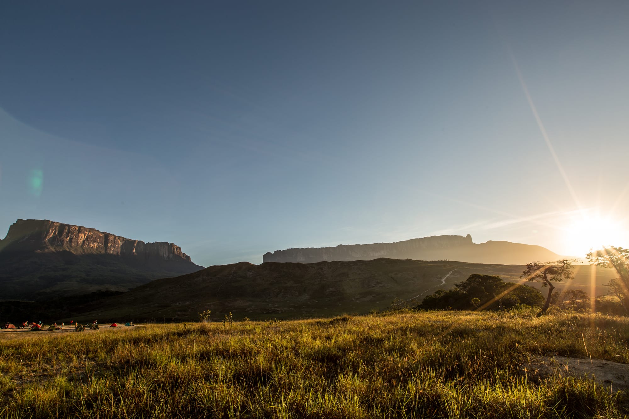
Two sheer-walled, flat-topped mountains above golden grassland at sunrise, with small tents in the foreground

Venezuela

Angel Falls, Canaima & the Guayana South

Kukenán tepui and Mount Roraima at sunrise, seen from the Gran Sabana trail. (Ney Teixeira de Freitas Guimarães Filho / Wikimedia Commons · CC BY-SA 4.0)

The vast, thinly peopled south of Venezuela, covering Bolívar and Amazonas states south of the Orinoco — the tepuis of Canaima and the Gran Sabana, Angel Falls, the river city of Ciudad Bolívar, the industrial belt of Ciudad Guayana and the Amazon rainforest of the Yanomami and Ye'kwana. This page is written to explain the region, not to encourage travel.

Explore Angel Falls, Canaima & the Guayana South

History

The Guayana highlands and the Amazon forest have been home for millennia to many indigenous peoples, among them the Pemón of the Gran Sabana, the Ye'kwana and the Piaroa along the rivers of Amazonas, and the Yanomami of the far south. Spanish expeditions searched the Orinoco for the golden city of El Dorado, and Walter Raleigh led English voyages upriver in 1595 and 1617. Catalan Capuchin missionaries founded missions along the Caroní in colonial times.

The river port of Angostura, founded in 1764 and renamed Ciudad Bolívar in 1846, was the base from which Bolívar relaunched the independence war. In 1819 the Congress of Angostura met there, heard his famous address and proclaimed the Republic of Colombia. The Angostura bitters first made in the town in the 1820s later moved with their makers to Trinidad.

Alexander von Humboldt travelled the Orinoco in 1800 and confirmed that the Casiquiare channel joins it to the Amazon basin. The US pilot Jimmie Angel landed on the Auyán-tepui in 1937, giving his name to the falls known to the Pemón as Kerepakupai Merú. From the 1960s the state built Ciudad Guayana, a planned industrial city at the meeting of the Caroní and Orinoco, with steel and aluminium plants and the Guri dam, which supplies much of the country's electricity. Canaima National Park became a UNESCO World Heritage Site in 1994. Since 2016 the government's Orinoco Mining Arc has opened vast areas to gold mining, much of it illegal and controlled by armed groups.

To the east lies the Essequibo region, administered by Guyana and claimed by Venezuela, a dispute now before the International Court of Justice.

Culture & Customs

Indigenous cultures shape much of the south. The Pemón, whose lands include Canaima and the Gran Sabana, tell stories of the tepuis as the homes of spirits and many work in tourism. In Amazonas the Ye'kwana live in communal houses called atta, the Piaroa see Cerro Autana as the tree of life of their oral tradition, and the Yanomami live in large oval communal dwellings called shabonos in the forest near the Brazilian border.

El Callao, a gold-mining town in eastern Bolívar, has a carnival with calypso music brought by migrants from Trinidad and the English-speaking Caribbean; the carnival is on UNESCO's intangible heritage list. Ciudad Bolívar has a strong river culture and the Orinoco is at the heart of its songs and legends.

Relations between indigenous communities and outsiders are tense in places: miners have invaded indigenous lands, and Pemón communities have clashed with security forces, notably around the Brazilian border in 2019.

Daily Life

Ciudad Guayana, joining Puerto Ordaz and San Félix, is the largest city, with about a million people in its metropolitan area. Ciudad Bolívar is the state capital, Puerto Ayacucho the capital of Amazonas, and Santa Elena de Uairén a trading town on the Brazilian border. Most of the region is empty forest and savanna, with indigenous villages reached by river or airstrip.

The steel, aluminium and iron-ore industries of Ciudad Guayana have declined heavily, and the Guri dam's failures contributed to the national blackouts of 2019. Gold mining, largely informal and often violent, has become the main economy in much of Bolívar and parts of Amazonas, drawing migrants from across the country. Santa Elena lives from trade with Brazil, and tourism supports Canaima and a handful of Gran Sabana villages.

Life in the mining towns is harsh: malaria, mercury poisoning, extortion by armed groups and shortages of fuel and medicine. Many families have left for Brazil and beyond.

Food

The Orinoco supplies the region's signature fish, the sapoara, which runs in August and is eaten baked, stuffed or in sancocho in Ciudad Bolívar, where local tradition says that anyone who eats its head will stay in the city. Other freshwater fish are staples along the Orinoco and Caroní.

Indigenous cooking is built on cassava. Casabe, a large, dry flatbread of grated bitter cassava, is made across the south, and mañoco, another bitter-cassava product, is eaten with broths. In Amazonas indigenous peoples prepare catara, a hot sauce made from cassava juice and large leafcutter ants. Cassava is also made into drinks.

In the towns, the national food is standard: arepas, empanadas and pabellón criollo. Ciudad Bolívar's markets sell river fish, tropical fruit and sweets, and Santa Elena's shops carry Brazilian goods alongside Venezuelan ones.

Attractions & Natural Wonders

Canaima National Park, a UNESCO World Heritage Site covering some 30,000 square kilometres, is the heart of the region. Canaima village sits on a lagoon on the Carrao River fed by a line of waterfalls, and Salto El Sapo lies nearby. From Canaima, motorised canoes travel up the Carrao and Churún rivers in the wet season to a camp facing Angel Falls, which drops about 979 metres from the Auyán-tepui; light-aircraft flights pass in front of it.

The Gran Sabana, in the park's eastern section, is a highland of grass, gallery forest and tepuis crossed by the road to Santa Elena de Uairén. Its waterfalls include Kama Merú, the red jasper stream bed of Quebrada de Jaspe and Salto Aponwao. From the Pemón village of Paraitepui, a trek of several days climbs Mount Roraima, whose summit plateau, scattered with quartz crystals, sits on the border with Brazil and Guyana. Kukenán tepui rises beside it.

Ciudad Bolívar has its colonial centre above the Orinoco and the Angostura bridge, and Ciudad Guayana has the falls of La Llovizna in a park on the Caroní. In Amazonas, Puerto Ayacucho lies beside the Atures rapids, with the natural rock slide of the Tobogán de la Selva nearby, and the rainforest stretches south to Cerro Autana, the Casiquiare channel and the Upper Orinoco.

Cities in Angel Falls, Canaima & the Guayana South

Planning basics

Budget

The south is reached almost entirely on organised trips, and those are priced in US dollars and are not cheap: a few days in Canaima with flights, camp and boat trips, or a guided Roraima trek with porters, costs far more than daily life in the cities. Ciudad Bolívar and Santa Elena are cheaper, but cash is scarce and cards rarely work.

Daily Budget Midrange
USD 150–350 (Canaima package with flights, camp, meals and the boat trip to Angel Falls)
Daily Budget Shoestring
USD 50–90 (guided group trek on Roraima or a basic posada in Ciudad Bolívar, simple food)

Book Canaima and Roraima as packages through an established operator, and bring all the US dollar cash needed for the trip.

Safety

Much of Bolívar and Amazonas is affected by illegal gold mining, run by armed criminal groups and, in places, guerrilla groups, with violence, abuse of workers and mercury pollution. Malaria is widespread in mining areas. The borders with Brazil and Guyana are dangerous, and the Essequibo dispute has raised military tension near the Guyana frontier.

Most governments advise against all or all-but-essential travel. Anyone who does go should keep strictly to organised trips to Canaima or Roraima, stay away from mining zones and border areas, and take malaria precautions. Check current official travel advice before travelling.

Climate

The Orinoco lowlands and Amazonas are hot and humid all year, with heavy rain from about May to November. The Gran Sabana, higher up, is milder, and tepui summits such as Roraima are cold, wet and often cloud-covered, and cold at night.

Summer
the wet season, May to November: heavy rain, full rivers and waterfalls, 22–32°C in the lowlands; cloud often hides the falls
Winter
the dry season, December to April: sunnier, with lower rivers; Angel Falls can dwindle to a thin stream

Transportation

Canaima is reached by light aircraft, usually from Ciudad Bolívar or Puerto Ordaz; the trip to Angel Falls is then by motorised canoe, taking several hours. A long road runs south from Ciudad Guayana across the Gran Sabana to Santa Elena de Uairén and Brazil. Amazonas is largely roadless beyond Puerto Ayacucho, and river and air travel depend on fuel that is often short.

Travel only as part of an organised itinerary, and avoid driving the southern highway, which passes through mining areas.

Best Time to Visit

For Angel Falls, the wet months from June to November bring the most water and allow boats up the Carrao and Churún rivers, though cloud may hide the top. The dry season from December to April is better for the Roraima trek and the Gran Sabana. Security matters more than the season.