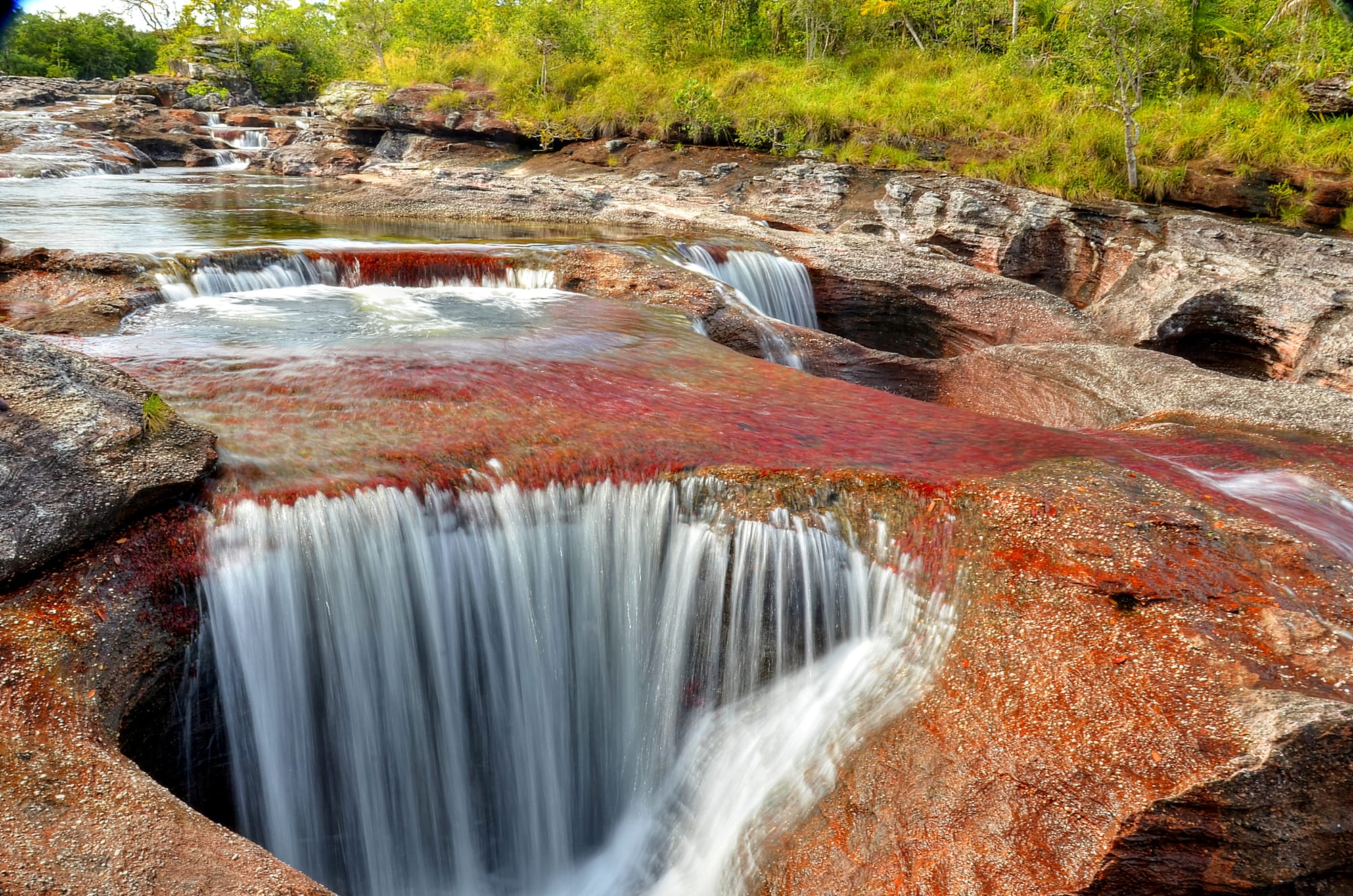
Water pouring into a round rock pothole beneath a riverbed covered in bright red aquatic plants

Colombia

Los Llanos & the Orinoco

Red river plants and a pothole waterfall at Caño Cristales, in the Sierra de la Macarena in Meta. (Gicaman / Wikimedia Commons · CC BY-SA 4.0)

The vast eastern half of Colombia, from the grassland plains below the Andes at Villavicencio to the Orinoco on the Venezuelan border and south into the forests of Guaviare, Vaupés and Guainía — cowboy country of cattle ranches, joropo and oil fields, and a sparsely populated frontier long shaped by armed conflict.

Explore Los Llanos & the Orinoco

History

The plains and forests of the east were the land of many Indigenous peoples — the Sikuani, Achagua, Piapoco and others on the savannas, and Tukano-speaking groups, Curripaco and Puinave in the rivers of the Amazon-Orinoco divide. Rock paintings in the Serranía de la Lindosa in Guaviare are among the oldest human traces in the region. From the 17th century, Jesuit missionaries set up missions and cattle ranches in Casanare and along the Meta river, and the herds that ran wild after their expulsion in 1767 were the basis of the llanero way of life.

The plains played a decisive role in independence. Llanero horsemen formed the backbone of the patriot cavalry, and in 1819 Bolívar and Santander led their army from Casanare over the frozen Andes of Pisba to win at Boyacá. After independence, the region was governed as a distant frontier; most of its departments — Arauca, Casanare, Vichada, Guaviare, Vaupés and Guainía — were territories until the 1991 constitution made them full departments. Villavicencio, founded in the 1840s, grew as the gateway to the plains.

During La Violencia, Liberal guerrillas of the Llanos led by Guadalupe Salcedo fought the Conservative government until a 1953 amnesty. Later the FARC made the Macarena and Guaviare strongholds, the ELN grew in Arauca around the Caño Limón oil field, and paramilitaries carried out massacres such as Mapiripán in 1997. Since the 2016 accord, parts of the region have opened to visitors, but the ELN and FARC dissidents continue to fight, particularly in Arauca and Guaviare.

Culture & Customs

The llanero — the cowboy of the plains — is the region's defining figure: a horseman proud of his independence, his cattle and his music. Llanero culture is shared with the Venezuelan plains, and joropo is its music and dance, with harp, cuatro and maracas accompanying singers in a fast, stamping rhythm. The work songs used to drive and milk cattle, recognised by UNESCO as intangible heritage in 2017, are shared with Venezuela.

Coleo, the region's sport, has riders chase a bull at full gallop and try to bring it down by twisting its tail; it is the highlight of local fairs. The Torneo Internacional del Joropo in Villavicencio brings together dancers, harpists and singers each year. Hospitality is generous, and a visitor to a ranch will often be welcomed with coffee and a meal.

The forests of Guaviare, Vaupés and Guainía are home to Indigenous peoples who make up a large share of the population, living largely in reserves: the Cubeo, Tukano and others in Vaupés, the Puinave and Curripaco in Guainía, and the Nukak of Guaviare, among the last nomadic peoples of Colombia.

Daily Life

Villavicencio, with about 550,000 people, is by far the largest city; Yopal has around 180,000, and the capitals of Arauca, Vichada, Guaviare, Vaupés and Guainía are small towns, with Puerto Carreño, Mitú and Inírida numbering in the tens of thousands or fewer. Much of the east has fewer than one person per square kilometre.

Oil is the region's economy: Meta and Casanare are major producers, with fields such as Rubiales in Meta and Cusiana and Cupiagua in Casanare, and the Caño Limón field in Arauca feeds a pipeline to the Caribbean that has been bombed many times. Cattle ranching remains the traditional base, alongside rice, palm oil and, increasingly, large-scale agriculture on the Altillanura of Meta and Vichada. Coca growing and illegal mining affect the remote south and east, and the forests of Guaviare have among the highest deforestation rates in Colombia.

Days begin before dawn on the ranches, with work paused in the midday heat. Weekend evenings in the towns mean joropo, beer and roast meat.

Food

The plains' signature dish is mamona, or ternera a la llanera: a young calf cut into large pieces, skewered on wooden stakes and slowly roasted over an open fire for hours, served with cassava, potatoes and plantain. Carne asada, pisillo (dried and shredded beef or fish) and gallina criolla (free-range chicken stew) are everyday dishes, and tamales are made for celebrations.

The rivers supply cachama and other fish, fried or grilled. In the Amazonian south and east, cassava is the staple, eaten as casabe bread and fariña, and people drink fermented or sweet cassava drinks.

Drinks include masato, a fermented rice or cassava drink, sweet coffee, and plenty of cold beer to beat the heat.

Attractions & Natural Wonders

Caño Cristales, in the Sierra de la Macarena National Park in Meta, is the region's most famous sight: for part of each year the aquatic plant Macarenia clavigera turns the riverbed red, with yellow sand, green algae and black rock, earning it the name "river of five colours". Visits are guided, by small plane to the town of La Macarena and then by boat and on foot. Villavicencio has its joropo halls, the Los Ocarros Bioparque and coleo arenas, and the nearby hot springs and waterfalls in the Andean foothills.

The Casanare savannas are the place to see the wildlife of the flooded plains: capybara, caiman, anacondas, giant anteaters and hundreds of bird species share the hatos with the cattle, and several ranches around Yopal and Paz de Ariporo welcome visitors. Puerto Carreño, capital of Vichada, stands where the Meta river flows into the Orinoco, facing Venezuela, and El Tuparro National Park, to its south, protects savanna, gallery forest and the Maipures rapids of the Orinoco.

In Guainía, the Cerros de Mavecure rise from the forest beside the Inírida river, near where the Inírida, Guaviare and Atabapo rivers flow together. In Guaviare, the Serranía de la Lindosa around San José del Guaviare has ancient rock paintings, among the oldest traces of people in the region, and Mitú in Vaupés is a base for visiting Indigenous communities.

Cities in Los Llanos & the Orinoco

Planning basics

Budget

Villavicencio and the towns of Meta and Casanare are inexpensive, with cheap hotels and generous plates of roast meat. Costs rise steeply for the remote highlights: Caño Cristales, the Casanare ranches, Puerto Carreño and Guainía are reached mainly by small or charter flights and are sold as packages with guides, lodging and park fees.

Daily Budget Midrange
USD 80–160 in the towns; package trips to Caño Cristales or a ranch stay cost considerably more
Daily Budget Shoestring
USD 30–50 (simple hotel, set lunches, buses) in Villavicencio and the plains towns

Book Caño Cristales and the Orinoco parks through licensed local operators, which handle permits, flights and guides.

Safety

Villavicencio, Yopal, the Casanare ranches and the organised Caño Cristales trips are visited without serious trouble. In Arauca the ELN and FARC dissidents have fought each other, in clashes that left 23 people dead in January 2022, and the ELN has repeatedly attacked the oil pipeline. Armed groups and trafficking networks are also present in rural Guaviare, southern Meta and along the Venezuelan border.

Avoid Arauca and the rural border areas, keep to organised trips in La Macarena and the Orinoco parks, and take malaria and yellow fever advice. Check current official travel advice before travelling.

Climate

Hot all year. The plains have one long dry season, which llaneros call summer, from about December to March, when grass browns, rivers shrink and wildlife gathers at the remaining water. From April to November the rains turn much of Casanare and Arauca into shallow floodplain. The forests of Guaviare, Vaupés and Guainía are wet and humid most of the year.

Summer
the dry season, about December–March: hot and sunny, 30–35°C, dusty roads, wildlife concentrated at water
Winter
the rainy season, about April–November: 25–32°C with heavy storms, flooded savanna and some roads cut

Transportation

Villavicencio is a few hours by road from Bogotá down a steep mountain highway that landslides sometimes close; from there buses run to Yopal and other plains towns. Caño Cristales is reached by small planes to La Macarena, and Puerto Carreño, Inírida, Mitú and Arauca have airports with limited flights, since overland travel is slow, seasonal or impossible. Rivers are the highways of the far east.

Allow extra time on the Bogotá–Villavicencio road in the rains, and confirm flights to the remote capitals well ahead.

Best Time to Visit

The dry season from December to March is best for wildlife on the Casanare ranches and for travel on the plains. Caño Cristales is best seen from about late June to November, when the river's plants show their colours after the rains. Villavicencio's joropo tournament is held around late June or early July.